อุทยานแห่งชาติเยลโลว์สโตน คือ อุทยานแห่งชาติสหรัฐอเมริกา และ มรดกโลกขององค์การยูเนสโก. เป็นอุทยานแห่งชาติแห่งแรกของโลก ตั้งไว้ในปี พ.ศ. 2415 เพื่ออนุรักษ์กีย์เซอร์จำนวนมหาศาล น้ำพุร้อนและพื้นที่ร้อนอื่นๆ ตลอดจนเพื่อปกป้องสัตว์ป่าอันน่าทึ่งและความงามที่ขรุขระของพื้นที่ สวนสาธารณะมีพื้นที่ 3,472 ตร.ไมล์ (8,990 กม.2) ส่วนใหญ่อยู่ภายใน ตะวันตกเฉียงเหนือ มุมของ ไวโอมิงแต่มีบางส่วนขยายไปถึงรัฐของ ไอดาโฮ และ มอนทานา.
เข้าใจ

ประวัติศาสตร์
เมื่อวันที่ 1 มีนาคม พ.ศ. 2415 เยลโลว์สโตนกลายเป็นคนแรก อุทยานแห่งชาติ เงินสำรองประกาศที่ใดก็ได้ในโลก โดยประธานาธิบดี Ulysses S. Grant ในปี พ.ศ. 2521 ได้กำหนดให้เป็น มรดกโลก. แม้ว่าโดยทั่วไปจะสันนิษฐานว่าชื่ออุทยานมาจากหินสีเหลืองที่เห็นในแกรนด์แคนยอนของเยลโลว์สโตน แต่ชื่อของอุทยานนั้นมาจากแม่น้ำเยลโลว์สโตนที่ไหลผ่าน ซึ่งได้รับการตั้งชื่อตามหน้าผาหินทรายที่อยู่ไกลออกไป มอนแทนาตะวันออก
ก่อนประวัติศาสตร์ของมนุษย์ที่บันทึกไว้ในเยลโลว์สโตน ภูเขาไฟระเบิดขนาดมหึมาได้พ่นเถ้าถ่านปริมาณมหาศาลที่ปกคลุมพื้นที่ทางตะวันตกของสหรัฐฯ แถบมิดเวสต์ บางส่วนของชายฝั่งตะวันออกของสหรัฐฯ ทางตอนเหนือของเม็กซิโก และบางพื้นที่ในแคนาดา การปะทุทิ้งแคลดีราไว้ประมาณ 34 คูณ 45 ไมล์ (55 คูณ 72 กม.) ดู ภูเขาไฟ สำหรับพื้นหลัง; เยลโลว์สโตนจัดอยู่ในประเภท a supervolcano และการปะทุครั้งสุดท้ายของมันคือ งาน VEI-8 ด้วยระยะทางกว่า 1,000 กม.3 ของอีเจ็คตา ซึ่งมีพลังมากกว่าการปะทุของ . ในปี 1980 ถึงพันเท่า ภูเขา เซนต์เฮเลนส์. เชื่อกันว่าซุปเปอร์ภูเขาไฟเยลโลว์สโตนจะปะทุทุกๆ 600,000 ถึง 900,000 ปี โดยครั้งสุดท้ายเกิดขึ้นเมื่อ 640,000 ปีก่อน การปะทุของมันเป็นหนึ่งในการปะทุครั้งใหญ่ที่สุดที่ทราบกันดีว่าเคยเกิดขึ้นบนโลก ทำให้เกิดการเปลี่ยนแปลงสภาพภูมิอากาศอย่างรุนแรงในภายหลัง
ภูมิทัศน์
ด้วยคุณสมบัติของความร้อนใต้พิภพครึ่งหนึ่งของโลก เยลโลว์สโตนถือเป็นแหล่งรวมกีย์เซอร์ น้ำพุร้อน บ่อโคลน และฟูมาโรลที่มีความหลากหลายและไม่บุบสลายมากที่สุดในโลก มีกีย์เซอร์มากกว่า 300 แห่ง ซึ่งคิดเป็น 2 ใน 3 ของไกเซอร์ทั้งหมดที่พบบนโลก เมื่อรวมเข้ากับคุณสมบัติด้านความร้อนมากกว่า 10,000 แห่ง ซึ่งประกอบด้วยน้ำพุร้อนสีสดใส หม้อโคลนเดือดปุดๆ และไอน้ำเดือด คุณก็จะมีสถานที่ที่ไม่เหมือนใคร
คุณสมบัติความร้อนใต้พิภพของเยลโลว์สโตนจะไม่เกิดขึ้นหากไม่มีตัวแมกมาที่อยู่เบื้องล่างซึ่งปล่อยความร้อนมหาศาล พวกเขายังขึ้นอยู่กับแหล่งน้ำเช่นจากภูเขารอบที่ราบสูงเยลโลว์สโตน ที่นั่น หิมะและฝนค่อยๆ ไหลซึมผ่านชั้นหินที่ซึมผ่านได้ซึ่งเต็มไปด้วยรอยแตก น้ำเย็นบางส่วนนี้ผสมกับน้ำเกลือร้อนซึ่งให้ความร้อนโดยตรงจากตัวหินหนืดตื้น อุณหภูมิของน้ำสูงขึ้นเหนือจุดเดือด แต่น้ำยังคงอยู่ในสถานะของเหลวเนื่องจากแรงดันและน้ำหนักของน้ำที่วางอยู่สูง ผลที่ได้คือน้ำร้อนยวดยิ่งที่มีอุณหภูมิเกิน 400 °F (200 °C)
น้ำร้อนจัดจะมีความหนาแน่นน้อยกว่าน้ำที่เย็นกว่าและหนักกว่าที่จมอยู่รอบๆ สิ่งนี้จะสร้างกระแสหมุนเวียนที่ช่วยให้น้ำที่ลอยตัวมากขึ้นและมีความร้อนสูงยิ่งยวดเริ่มเดินทางกลับสู่พื้นผิวตามรอยร้าวและพื้นที่ที่อ่อนแอผ่านกระแสลาวาไรโอลิติก ทางเดินขึ้นด้านบนนี้เป็นระบบ "ประปา" ตามธรรมชาติของลักษณะพิเศษของความร้อนใต้พิภพของอุทยาน เมื่อถึงผิวน้ำ สีต่างๆ ของสระน้ำก็เกิดจากแบคทีเรียประเภทต่างๆ ที่เติบโตในอุณหภูมิที่ต่างกัน
พืชและสัตว์

อุทยานแห่งนี้เป็นแกนหลักของระบบนิเวศ Greater Yellowstone ซึ่งเป็นระบบนิเวศในเขตอบอุ่นที่ใหญ่ที่สุดแห่งหนึ่งที่ยังคงเหลืออยู่บนโลก และเป็นผลให้พื้นที่พิเศษสำหรับการดูสัตว์ป่า
เยลโลว์สโตนเป็นที่อยู่อาศัยของสัตว์เลี้ยงลูกด้วยนมที่มีความเข้มข้นมากที่สุดใน 48 รัฐตอนล่าง สัตว์เลี้ยงลูกด้วยนมที่แตกต่างกันหกสิบเจ็ดตัวอาศัยอยู่ที่นี่ รวมทั้งหมีกริซลี่และหมีดำ หมาป่าสีเทาถูกล่าจนสูญพันธุ์ในปี 1926 แต่ได้รับการแนะนำให้รู้จักกับแคนาดาในปี 1995 และตอนนี้มีมากกว่า 100 ตัวอาศัยอยู่ในอุทยาน ทำให้เป็นหนึ่งในสถานที่ที่ดีที่สุดที่จะได้เห็นพวกมันในป่า นอกจากนี้ อุทยานแห่งนี้ยังเป็นบ้านของประชากรหมาป่าและจิ้งจอกแดงที่เฟื่องฟูอีกด้วย วูล์ฟเวอรีนและแมวป่าชนิดหนึ่งซึ่งต้องการพื้นที่กว้างใหญ่ที่ไม่ถูกรบกวนก็พบได้ในระบบนิเวศของเยลโลว์สโตน มีกีบเท้าพื้นเมืองเจ็ดชนิด - กวาง กวางล่อ วัวกระทิง กวางมูส แกะเขาใหญ่ ง่าง และกวางหางขาวอาศัยอยู่ที่นี่ แพะภูเขาที่ไม่ใช่คนพื้นเมืองได้เข้ามาตั้งรกรากในตอนเหนือของอุทยาน และสัตว์เลี้ยงลูกด้วยนมขนาดเล็กจำนวนมาก รวมทั้งบีเว่อร์จะพบได้ทั่วทั้งอุทยาน
บันทึกการพบเห็นนกถูกเก็บไว้ในเยลโลว์สโตนตั้งแต่ก่อตั้งในปี 2415; บันทึกเหล่านี้บันทึก 330 ชนิดของนกจนถึงปัจจุบัน ซึ่งประมาณ 148 สายพันธุ์เป็นที่รู้จักกันดีในการทำรังในอุทยาน ความผันแปรของระดับความสูงและประเภทที่อยู่อาศัยที่หลากหลายที่พบในอุทยานมีส่วนทำให้ภูมิภาคนี้มีความหลากหลายค่อนข้างสูง
กิจกรรมของธารน้ำแข็งและสภาพอากาศที่เย็นและแห้งในปัจจุบันมีแนวโน้มที่จะเป็นสาเหตุของสัตว์เลื้อยคลานและสัตว์ครึ่งบกครึ่งน้ำจำนวนค่อนข้างน้อยที่พบในอุทยาน
เยลโลว์สโตนเป็นที่อยู่อาศัยของพืชหลอดเลือดมากกว่า 1,350 ชนิด โดย 218 ชนิดไม่ใช่พืชพื้นเมือง
ภูมิอากาศ
| อุทยานแห่งชาติเยลโลว์สโตน | ||||||||||||||||||||||||||||||||||||||||||||||||||||||||||||
|---|---|---|---|---|---|---|---|---|---|---|---|---|---|---|---|---|---|---|---|---|---|---|---|---|---|---|---|---|---|---|---|---|---|---|---|---|---|---|---|---|---|---|---|---|---|---|---|---|---|---|---|---|---|---|---|---|---|---|---|---|
| แผนภูมิภูมิอากาศ (คำอธิบาย ) | ||||||||||||||||||||||||||||||||||||||||||||||||||||||||||||
| ||||||||||||||||||||||||||||||||||||||||||||||||||||||||||||
| ||||||||||||||||||||||||||||||||||||||||||||||||||||||||||||
สภาพอากาศในอุทยานแห่งชาติเยลโลว์สโตนสามารถเปลี่ยนแปลงอย่างรวดเร็วจากแสงแดดและอบอุ่นเป็นเย็นและฝนตก ดังนั้นจึงควรนำเสื้อผ้าหลายชั้นที่สามารถใช้ได้ตามความจำเป็นติดตัวไปด้วย หิมะสามารถตกในเยลโลว์สโตนได้ตลอดเวลาของปี
- ฤดูร้อน: อุณหภูมิในตอนกลางวันมักอยู่ที่ 70s F (25 °C) และบางครั้งในช่วง 80s F (30 °C) ในระดับความสูงที่ต่ำกว่า กลางคืนมักจะเย็นและอุณหภูมิอาจลดลงต่ำกว่าจุดเยือกแข็งที่ระดับความสูงที่สูงขึ้น พายุฝนฟ้าคะนองเป็นเรื่องปกติในช่วงบ่าย
- ฤดูหนาว: อุณหภูมิมักจะอยู่ในช่วงตั้งแต่ 0 ถึง 20 °F (-20 ถึง -5 °C) ตลอดทั้งวัน อุณหภูมิต่ำกว่าศูนย์ในชั่วข้ามคืนเป็นเรื่องปกติ อุณหภูมิต่ำสุดที่บันทึกได้คือ −66 °F (−54 °C) ปริมาณหิมะมีความแปรปรวนสูง แม้ว่าค่าเฉลี่ยจะอยู่ที่ 150 นิ้ว (3,800 มม.) ต่อปี แต่ก็ไม่ใช่เรื่องแปลกที่ระดับความสูงที่สูงขึ้นจะได้รับสองเท่าของจำนวนดังกล่าว
- ฤดูใบไม้ผลิ & ฤดูใบไม้ร่วง: อุณหภูมิในช่วงกลางวันอยู่ในช่วง 30 ถึง 60 วินาที (0 ถึง 20 °C) โดยในช่วงวัยรุ่นจะมีอุณหภูมิต่ำสุดในชั่วข้ามคืนไปจนถึงตัวเลขหลักเดียว (-5 ถึง -20 °C) หิมะเป็นเรื่องปกติในฤดูใบไม้ผลิและฤดูใบไม้ร่วง โดยมีปริมาณสะสมปกติ 12 นิ้ว ในช่วงเวลา 24 ชั่วโมง ทุกช่วงเวลาของปี ให้เตรียมพร้อมสำหรับการเปลี่ยนแปลงอย่างกะทันหัน ความคาดเดาไม่ได้เหนือสิ่งอื่นใดคือลักษณะสภาพอากาศของเยลโลว์สโตน ตัวเลือกเสื้อผ้าที่หลากหลาย อย่าลืมนำเสื้อแจ็คเก็ตที่อบอุ่นและอุปกรณ์กันฝนมาด้วยแม้ในฤดูร้อน
เข้าไป

โดยเครื่องบิน
สนามบินหลักที่ให้บริการเยลโลว์สโตนคือ สนามบินแจ็คสันโฮล (JAC IATA) ใน อุทยานแห่งชาติแกรนด์เทตัน, ใกล้ แจ็คสันและสนามบินที่ใหญ่ที่สุดใน ไวโอมิง. United และ Delta ให้บริการ Jackson Hole ตลอดทั้งปีจาก เดนเวอร์ และ ซอลต์เลกซิตี้ ตามลำดับ สายการบินเหล่านี้รวมถึง American และ Frontier ให้บริการเที่ยวบินตามฤดูกาลจากเมืองเหล่านั้นและอีกแปดแห่งทั่วสหรัฐอเมริกา
สนามบินอื่นที่ให้บริการเชิงพาณิชย์อยู่ที่:
- บิลลิงส์ (มอนทาน่า) (บิลลี่ IATA). จากหลายเมือง
- โบซแมน (มอนทาน่า) (BZN IATA). จากแปดเมืองตลอดทั้งปีและมากขึ้นตามฤดูกาล
- โคดี้ (ไวโอมิง) (COD IATA) ท่าอากาศยานภูมิภาคเยลโลว์สโตน จากซอลท์เลคซิตี้และเดนเวอร์
- ไอดาโฮฟอลส์ (ไอดาโฮ) (ไอด้า IATA). จากหกเมือง
- ซอลต์เลกซิตี้ (ยูทาห์) (SLC IATA). ขับรถมาไกลหน่อย (ประมาณ 6 ชั่วโมง) แต่ยังคงเป็นสนามบินหลักที่อยู่ใกล้สวนสาธารณะมากที่สุด โดยมีเที่ยวบินจากเมืองใหญ่ๆ ทั่วประเทศ รวมถึงเที่ยวบินระหว่างประเทศที่จำกัด
- เวสต์เยลโลว์สโตน (มอนทาน่า) (WYS IATA). จากซอลต์เลกซิตี ช่วง มิ.ย.–ก.ย. เท่านั้น
โดยรถยนต์
ทางเข้าอุทยานมี 5 ทาง เมืองที่ใกล้ที่สุดของแต่ละทางเข้าจะได้รับ
- 1 ทิศเหนือ - เข้าถึงได้จาก การ์ดิเนอร์ (มอนแทนา) ผ่านเส้นทาง US Route 89, 56 ไมล์ (90 กม.) จาก ลิฟวิงสตัน. ทางเข้านี้เปิดตลอดทั้งปีและนำไปสู่สำนักงานใหญ่ของอุทยานที่ บ่อน้ำพุร้อนแมมมอธ, 5 ไมล์ (8.0 กม.) ภายในเขตอุทยาน. สัญลักษณ์ Roosevelt Arch อยู่ที่ทางเข้านี้
- 2 ภาคตะวันออกเฉียงเหนือ - เข้าถึงได้จาก ประตูเงิน และ เมืองคุก ผ่านทางหลวงหมายเลข 212 ของสหรัฐอเมริกา (ทางหลวง Beartooth) ทางเข้าและถนนสู่เมืองคุกเปิดตลอดทั้งปี แต่เส้นทาง 212 ผ่านเมืองคุกจะปิดในฤดูหนาว (กลางเดือนตุลาคมถึงปลายเดือนพฤษภาคม)
- 3 ตะวันออก - เข้าถึงได้จาก โคดี้, 53 ไมล์ (85 กม.) ผ่านทางหลวงหมายเลข 14/16/20 ของสหรัฐอเมริกา ทางเข้านี้ปิดให้บริการในฤดูหนาว (ต้นเดือนพฤศจิกายนถึงต้นเดือนพฤษภาคม)
- 4 ใต้ - เข้าถึงได้จาก อุทยานแห่งชาติแกรนด์เทตัน ผ่านเส้นทางสหรัฐ 89/191/287 ทางเข้านี้ปิดให้บริการในฤดูหนาว (ต้นเดือนพฤศจิกายนถึงกลางเดือนพฤษภาคม)
- 5 ตะวันตก - เข้าถึงได้จาก เวสต์เยลโลว์สโตน ผ่านทางหลวงหมายเลข 20/191/287 ของสหรัฐอเมริกา 60 ไมล์ (97 กม.) จาก แอชตัน ไอดาโฮ. ทางเข้านี้ปิดในฤดูหนาว (ต้นเดือนพฤศจิกายนถึงปลายเดือนเมษายน)
โดยเท้า
มีเส้นทางมากมายเข้าสู่อุทยานทุกด้าน รวมทั้งเส้นทางยาว 3100 ไมล์ (5,000 กม.) Continental Divide Trail.
ค่าธรรมเนียมและใบอนุญาต
ยานพาหนะและบุคคลที่เข้ามาในอุทยานจะต้องชำระค่าธรรมเนียมแรกเข้าซึ่งมีอายุเจ็ดวัน ค่าธรรมเนียม ณ ปี 2020 คือ:
- $20 - บุคคลทั่วไปเดินเท้า ปั่นจักรยาน ฯลฯ
- $30 - รถจักรยานยนต์หรือสโนว์โมบิล
- $35 - รถยนต์ที่ไม่ใช่เชิงพาณิชย์
- 70 ดอลลาร์ - บัตรผ่านรายปีของอุทยานแห่งชาติเยลโลว์สโตน อนุญาตให้ใช้รถยนต์ส่วนตัวเข้าอุทยานเป็นเวลาหนึ่งปี
ในขณะที่ค่าธรรมเนียมแรกเข้าในเยลโลว์สโตนก็รวมค่าธรรมเนียมสำหรับการเข้าด้วย อุทยานแห่งชาติแกรนด์เทตันผู้เข้าชมที่วางแผนจะเยี่ยมชมสวนสาธารณะทั้งสองแห่งจะต้องจ่ายค่าธรรมเนียมแรกเข้าแยกต่างหากสำหรับแต่ละอุทยาน
มีหลายอย่าง ผ่าน สำหรับกลุ่มที่เดินทางด้วยกันในรถยนต์ส่วนตัวหรือบุคคลโดยการเดินเท้า/จักรยานที่ให้สิทธิ์เข้าอุทยานแห่งชาติเยลโลว์สโตนและอุทยานแห่งชาติทั้งหมดฟรี รวมถึงอนุสรณ์สถานแห่งชาติ เขตรักษาพันธุ์สัตว์ป่าแห่งชาติ และป่าสงวนแห่งชาติ:
- $80 บัตรรายปี (มีอายุสิบสองเดือนนับจากวันที่ออก) ทุกคนสามารถซื้อได้ บุคลากรทางทหารสามารถรับบัตรผ่านฟรีโดยแสดง Common Access Card (CAC) หรือ Military ID
- $80 ผ่านอาวุโส (ใช้ได้ตลอดอายุผู้ถือ) ให้บริการแก่พลเมืองสหรัฐฯ หรือผู้อยู่อาศัยถาวรที่มีอายุ 62 ปีขึ้นไป ผู้สมัครจะต้องจัดเตรียมเอกสารการเป็นพลเมืองและอายุ บัตรผ่านนี้ยังมอบส่วนลด 50 เปอร์เซ็นต์สำหรับสิ่งอำนวยความสะดวกบางอย่างในอุทยาน ผู้สูงอายุสามารถรับบัตรผ่านรายปี $20 ได้เช่นกัน
- ฟรี การเข้าถึงผ่าน (ใช้ได้ตลอดอายุผู้ถือ) มีให้สำหรับพลเมืองสหรัฐฯ หรือผู้อยู่อาศัยถาวรที่มีความทุพพลภาพถาวร ผู้สมัครจะต้องจัดเตรียมเอกสารการเป็นพลเมืองและความทุพพลภาพถาวร บัตรผ่านนี้ยังมอบส่วนลด 50 เปอร์เซ็นต์สำหรับสิ่งอำนวยความสะดวกบางอย่างในอุทยาน
- ฟรี บัตรอาสาสมัคร มีให้สำหรับบุคคลที่อาสาสมัคร 250 ชั่วโมงขึ้นไปกับหน่วยงานของรัฐบาลกลางที่เข้าร่วมในโครงการ Interagency Pass
- ฟรี ผ่านชั้นประถมศึกษาปีที่ 4 ประจำปี (ใช้ได้ในเดือนกันยายน-สิงหาคมของชั้นประถมศึกษาปีที่ 4) อนุญาตให้ผู้ถือและผู้โดยสารที่มากับรถเข้ามาในรถส่วนตัวที่ไม่ใช่เชิงพาณิชย์ได้ ลงทะเบียนที่ เด็กทุกคนนอกบ้าน จำเป็นต้องมีเว็บไซต์
กรมอุทยานฯ เปิดให้เข้าชมอุทยานแห่งชาติทุกแห่งฟรี 5 วันทุกปี:
- วันมาร์ติน ลูเธอร์ คิง จูเนียร์ (วันจันทร์ที่สามของเดือนมกราคม); เทศกาลต่อไปคือวันที่ 18 มกราคม 2021
- วันแรกของสัปดาห์อุทยานแห่งชาติ (วันเสาร์ที่สามของเดือนเมษายน); เทศกาลต่อไปคือวันที่ 17 เมษายน 2021
- วันเกิดบริการอุทยานแห่งชาติ (25 สิงหาคม)
- วันที่ดินสาธารณะแห่งชาติ (วันเสาร์ที่สี่ของเดือนกันยายน); เทศกาลต่อไปคือวันที่ 25 กันยายน 2021
- วันทหารผ่านศึก (11 พฤศจิกายน)
ไปรอบ ๆ

วิธีที่มีประโยชน์ในการปรับทิศทางตัวเองคือ นึกภาพถนนในเยลโลว์สโตนให้เป็นรูปร่าง "รูปที่ 8" วงล่าง West Thumb - Old Faithful - Madison - Norris - Canyon - Lake Village - West Thumb ประมาณ 90 ไมล์ (140 กิโลเมตร) วงบน Norris - Mammoth - Tower-Roosevelt - Canyon - Norris อยู่ห่างออกไปประมาณ 70 ไมล์ (110 กิโลเมตร) สวนสาธารณะคือ ใหญ่.
โดยรถยนต์
ผู้เยี่ยมชมส่วนใหญ่ใช้รถยนต์ส่วนตัวเพื่อเดินทางภายในอุทยานแห่งชาติเยลโลว์สโตน ถนนจะแออัดมากเมื่อใดก็ตามที่ผู้คนหยุดดูสัตว์ป่า ใช้ pullouts และให้เกียรติผู้ขับขี่อื่น ๆ เพื่อช่วยหลีกเลี่ยง หมีแยม. เมื่อหิมะตก ถนนอาจถูกปิด และในช่วงเดือนฤดูหนาว ถนนในสวนสาธารณะหลายแห่งจะปิดอย่างถาวร
โดยรถประจำทาง
ไม่มีบริการขนส่งสาธารณะภายในอุทยาน แซนเทอรา รีสอร์ท ให้บริการนำเที่ยวภายในอุทยานในช่วงฤดู ร้อน ทัวร์รอบล่างจะออกเดินทางจากสถานที่ทางตอนใต้ของอุทยานเท่านั้น ทัวร์ Upper Loop ออกเดินทางจากโรงแรม Lake Hotel, Fishing Bridge RV Park และ Canyon Lodge เพื่อทัวร์ส่วนทางเหนือของอุทยานเท่านั้น ทัวร์ Grand Loop ออกเดินทางจาก Gardiner และ Mammoth Hot Springs Hotel เพื่อทัวร์ทั่วทั้งอุทยานในหนึ่งวัน ในช่วงฤดู หนาวจะมีทัวร์สโนว์โค้ชให้บริการจากสถานที่ต่างๆ โทร 1 307 344-7311 เพื่อสอบถามข้อมูลหรือสำรองที่นั่ง
นอกจากนี้ ในช่วงฤดูร้อน ธุรกิจการค้าเสนอทัวร์ที่มีต้นกำเนิดจากเมืองและเมืองต่างๆ ในพื้นที่ ในช่วงฤดูหนาว ธุรกิจบางแห่งจะให้บริการนำเที่ยวด้วยรถสโนว์โค้ชสำหรับถนนในสวนสาธารณะหรือรถประจำทางส่วนใหญ่บนน้ำพุร้อน Mammoth ไปยังถนน Cooke City
โดยจักรยาน
ปั่นจักรยาน ในสวนสาธารณะอาจเป็นประสบการณ์ที่คุ้มค่า แต่เนื่องจากระยะทางที่ห่างไกลในอุทยาน การวางแผนเพิ่มเติมบางอย่างจึงจำเป็นเพื่อให้แน่ใจว่ามีที่พักให้บริการทุกคืน อุทยานสงวนพื้นที่ตั้งแคมป์ไว้สำหรับนักปั่นจักรยานจำนวนมาก แต่ในช่วงฤดูร้อนที่วุ่นวาย อาจเป็นการดีที่สุดที่จะจองสถานที่ล่วงหน้าหากทำได้
โดยสโนว์โมบิลหรือสโนว์โค้ช
ฤดูหนาวอาจเป็นช่วงเวลาที่เงียบสงบที่สุดในการเยี่ยมชมอุทยานเมื่อมีผู้มาเยือนน้อยที่สุด ฤดูการใช้งานสโนว์โมบิลและสโนว์โค้ชในฤดูหนาวเริ่มต้นในกลางเดือนธันวาคมและสิ้นสุดในกลางเดือนมีนาคม วันที่เปิดหรือปิดจริงสำหรับการเดินทางที่มีหิมะตกจะแตกต่างกันไปตามทางเข้าและจะถูกกำหนดโดยสโนว์แพ็คและตารางการไถพรวนที่เพียงพอ ผู้เข้าชมที่ต้องการเยี่ยมชมสวนสาธารณะด้วยสโนว์โมบิลหรือรถสโนว์โคชจะต้องเดินทางโดยรถสโนว์โคชเชิงพาณิชย์หรือไกด์นำเที่ยวเชิงพาณิชย์บนสโนว์โมบิล (ไม่อนุญาตให้ใช้สโนว์โมบิลแบบส่วนตัวหรือแบบไม่มีไกด์) ซึ่งมีให้ที่ทางเข้าส่วนใหญ่ จำเป็นต้องมีเทคโนโลยีที่ดีที่สุดสำหรับเคลื่อนบนหิมะ และมีการจำกัดรายการสำหรับรถสำหรับเคลื่อนบนหิมะและรถสำหรับเคลื่อนบนหิมะทุกวัน ไม่อนุญาตให้ใช้สโนว์โมบิลและสโนว์โค้ชแบบออฟโรด
ดู

เยลโลว์สโตนมีชื่อเสียงระดับโลกในด้านมรดกทางธรรมชาติและความงาม และด้วยข้อเท็จจริงที่ว่าเยลโลว์สโตนมีคุณสมบัติความร้อนใต้พิภพถึงครึ่งโลก โดยมีตัวอย่างมากกว่า 10,000 ตัวอย่าง นักท่องเที่ยวที่มาเยือนเยลโลว์สโตนสามารถชมน้ำพุร้อนมากกว่า 300 แห่ง (เช่น "Old Faithful") แอ่งโคลนเดือด และสัตว์ป่านานาชนิด เช่น หมีกริซลี่ย์ หมาป่า วัวกระทิง และกวางเอลค์ ทั้งหมดนี้ยืนอยู่บนพื้นผิวโลก "ซุปเปอร์ภูเขาไฟ" ที่ใหญ่ที่สุดที่รู้จักกันดี
อุทยานสามารถแบ่งย่อยออกเป็นพื้นที่หลัก ๆ ได้ประมาณแปดแห่ง ซึ่งจัดไว้ด้านล่าง เนื่องจากอาจพบเห็นได้โดยผู้ที่เดินทางในอุทยานตามเข็มนาฬิกา โดยเริ่มจากทิศตะวันออก
อ่าวสะพาน สะพานตกปลา และทะเลสาบ
ทั้งสามภูมิภาคนี้ตั้งอยู่ทางด้านเหนือของทะเลสาบเยลโลว์สโตน ตัวเลือกนันทนาการรวมถึงการพายเรือ การตกปลา และคุณสมบัติด้านความร้อนจำนวนหนึ่ง
ลักษณะทางความร้อนและสถานที่ท่องเที่ยวทางธรรมชาติในบริเวณนี้ ได้แก่:
- 1 ทะเลสาบเยลโลว์สโตน. ทะเลสาบเยลโลว์สโตนมีพื้นที่ 132 ตารางไมล์ (340 ตารางกิโลเมตร) เป็นทะเลสาบที่ใหญ่ที่สุดที่ระดับความสูง (มากกว่า 7,000 ฟุต) ในอเมริกาเหนือ เป็นทะเลสาบธรรมชาติ ตั้งอยู่เหนือระดับน้ำทะเล 7,733 ฟุต (2,357 ม.) มีความยาวประมาณ 20 ไมล์ (32 กม.) และกว้าง 15 ไมล์ (24 กม.) โดยมีแนวชายฝั่ง 141 ไมล์ (227 กม.) มันถูกแช่แข็งเกือบครึ่งปี อากาศจะแข็งตัวในช่วงปลายเดือนธันวาคมหรือต้นเดือนมกราคม และจะละลายในปลายเดือนพฤษภาคมหรือต้นเดือนมิถุนายน


- เฮย์เดนและหุบเขานกกระทุงan. Hayden Valley อยู่ห่างจากชุมทางสะพานตกปลาไปทางเหนือ 6 ไมล์ (9.7 กม.) หุบเขา Pelican Valley อยู่ห่างจากสะพาน Fishing Bridge ไปทางตะวันออก 4.8 กม. หุบเขากว้างใหญ่สองแห่งนี้ประกอบด้วยที่อยู่อาศัยที่ดีที่สุดใน 48 รัฐตอนล่างสำหรับหมีกริซลี่ กระทิง กวางเอลค์ และสัตว์ป่าสายพันธุ์อื่นๆ
- 2 สะพานธรรมชาติ (ทางใต้ของที่ตั้งแคมป์บริดจ์เบย์). กลุ่มหินนี้สามารถเข้าถึงได้ด้วยการเดินเพียง 1.6 กม. และยังมีเส้นทางจักรยานที่มุ่งสู่สะพานอีกด้วย สะพานธรรมชาติเกิดขึ้นจากการกัดเซาะของหินไรโอไลต์โผล่ขึ้นมาจากสะพานครีก ด้านบนของสะพานสูงจากลำห้วยประมาณ 51 ฟุต (16 ม.) ทางเดินสลับสั้น ๆ นำไปสู่ด้านบน แม้ว่าขณะนี้ห้ามไม่ให้เดินทางข้ามสะพานเพื่อปกป้องคุณลักษณะนี้
- 3 LeHardy Rapids (4.8 กม. ทางเหนือของสะพานตกปลา). LeHardy Rapids เป็นน้ำตกในแม่น้ำเยลโลว์สโตน ตามหลักธรณีสัณฐาน คิดว่านี่คือจุดจริงที่ทะเลสาบสิ้นสุดและแม่น้ำยังคงไหลไปทางเหนือ ในฤดูใบไม้ผลิ อาจพบเห็นปลาเทราต์คอดหลายตัวที่นี่ พักในแอ่งน้ำตื้นก่อนที่จะใช้พลังงานระเบิดเพื่อกระโจนไปตามกระแสน้ำเพื่อวางไข่ใต้สะพานตกปลา ทางเดินริมทะเลที่สร้างขึ้นในปี 1984 ช่วยให้เข้าถึงพื้นที่ได้ แม้ว่าจะปิดในช่วงฤดูใบไม้ผลิเพื่อทำรังเพื่อปกป้องที่อยู่อาศัยของนกที่มีความอ่อนไหว
- 4 ภูเขาไฟโคลน. ครั้งหนึ่งเคยเป็นคุณลักษณะด้านความร้อนบนยอดเขาที่จะสาดโคลนใส่ต้นไม้ที่อยู่ใกล้เคียงในระหว่างการปะทุ แต่การปะทุครั้งใหญ่โดยเฉพาะอย่างยิ่งทำให้ภูเขาไฟโคลนแตกเป็นเสี่ยง ๆ ทิ้งแอ่งโคลนที่ร้อนระอุอยู่ที่ฐานของเนินเขา การเข้าถึงพื้นที่ใช้วงล้อสั้น ๆ จากลานจอดรถผ่านปากมังกรและภูเขาไฟโคลนที่เข้าถึงได้สำหรับผู้พิการ และทางเดินบนวนครึ่งไมล์ (800 ม.) ผ่านทะเลสาบเปรี้ยวและแอ่งน้ำมังกรดำที่ค่อนข้างชัน . การพ่นไอน้ำเป็นจังหวะและลิ้นที่วาววับทำให้ชื่อน้ำพุปากมังกร แม้ว่ากิจกรรมจะลดลงอย่างเห็นได้ชัดตั้งแต่เดือนธันวาคม 1994 Caldron ของ Black Dragon ได้ระเบิดลงบนภูมิประเทศในปี 1948 พัดต้นไม้ออกจากรากและปกคลุมบริเวณโดยรอบ ป่าที่มีโคลน ในเดือนมกราคม 1995 คุณลักษณะใหม่บนชายฝั่งทางใต้ของบ่อน้ำพุร้อนโคลนเริ่มมีบทบาทอย่างมาก ครอบคลุมพื้นที่ 20 x 8 ฟุต (6.1 ม. × 2.4 ม.) และประกอบด้วย fumaroles แอ่งน้ำขนาดเล็ก และลักษณะประเภทกระทะ ลักษณะที่น่าทึ่งที่สุดของพื้นที่ภูเขาไฟโคลน ซึ่งรวมถึงหม้อโคลนขนาดใหญ่ที่เรียกว่า "กัมเปอร์" เปิดให้ประชาชนทั่วไปได้เข้าชมผ่านทางเดินที่มีไกด์นำทางโดยเจ้าหน้าที่พิทักษ์ป่าเท่านั้น
- 5 กำมะถัน Caldron. สามารถมองเห็นพื้นที่ Sulphur Caldron ได้จากพื้นที่แสดงละครทางเหนือของ Mud Volcano น้ำที่สาดกระเซ็นปั่นป่วนของ Sulphur Caldron เป็นน้ำสีเหลืองที่มีความเป็นกรดมากที่สุดในอุทยานโดยมีค่า pH 1.3 คุณสมบัติอื่น ๆ ที่สามารถมองเห็นได้จากมุมมองนี้คือ สระน้ำปั่นป่วน (ซึ่งไม่ "ปั่นป่วน") และปล่องของหม้อโคลนขนาดใหญ่ที่ยังคุกรุ่นอยู่
สถานที่ท่องเที่ยวทางประวัติศาสตร์และการศึกษาในบริเวณนี้ ได้แก่ :
- 6 สะพานตกปลา. สะพานเดิมสร้างขึ้นในปี ค.ศ. 1902 โดยเป็นสะพานไม้จากผ้าลูกฟูกที่ตัดอย่างหยาบ โดยมีการจัดตำแหน่งที่ต่างจากสะพานปัจจุบันเล็กน้อย สะพานที่มีอยู่สร้างขึ้นในปี 2480 สะพานตกปลาในอดีตเป็นสถานที่ตกปลายอดนิยมอย่างมาก การตกปลาจากสะพานทำได้ค่อนข้างดี เนื่องจากเป็นพื้นที่วางไข่ที่สำคัญของปลาเทราต์ที่ฆ่า อย่างไรก็ตาม เนื่องจากการลดลงของจำนวนฆาตกร (ส่วนหนึ่งเป็นผลมาจากการปฏิบัตินี้) สะพานจึงถูกปิดไม่ให้ทำการประมงในปี 1973 นับแต่นั้นเป็นต้นมา สะพานได้กลายเป็นสถานที่ยอดนิยมในการดูปลา
- 7 พิพิธภัณฑ์สะพานประมงและศูนย์บริการนักท่องเที่ยว. พิพิธภัณฑ์สะพานตกปลาสร้างเสร็จในปี 1931 และในที่สุดก็จะกลายเป็นต้นแบบของสถาปัตยกรรมแบบชนบทในสวนสาธารณะทั่วประเทศ ได้รับการประกาศให้เป็นสถานที่สำคัญทางประวัติศาสตร์แห่งชาติในปี พ.ศ. 2530 เมื่อรถยนต์เข้ามาแทนที่รถสเตจโค้ชเป็นวิธีหลักในการคมนาคมผ่านอุทยาน ผู้คนจึงไม่มีไกด์นำทางไปด้วย ดังนั้นพิพิธภัณฑ์จึงถูกสร้างขึ้นเป็น "พิพิธภัณฑ์ริมทาง" เพื่อให้ผู้มาเยี่ยมชมได้รับข้อมูล เกี่ยวกับเยลโลว์สโตนด้วยตัวเอง
- 8 โรงแรมเลค เยลโลว์สโตน. โรงแรมเลค เยลโลว์สโตน เปิดให้บริการในปี พ.ศ. 2434 บนพื้นที่ที่รู้จักกันมานานว่าเป็นสถานที่นัดพบของชาวอินเดีย ผู้ดักสัตว์ และคนภูเขา ในเวลานั้น มันไม่ได้โดดเด่นเป็นพิเศษ คล้ายกับโรงแรมรถไฟอื่น ๆ ที่ได้รับทุนจากทางรถไฟแปซิฟิกเหนือ ได้รับการปรับปรุงใหม่ในปี พ.ศ. 2446 โดยมีการเปลี่ยนแปลงเพิ่มเติมในปี พ.ศ. 2472 ภายในปี พ.ศ. 2513 โรงแรมได้ทรุดโทรมอย่างรุนแรง ในปีพ.ศ. 2524 กรมบริการอุทยานแห่งชาติและผู้รับสัมปทานอุทยาน TW Recreational Services ได้เริ่มดำเนินการตามโครงการระยะเวลาสิบปีเพื่อฟื้นฟูโรงแรมเลคให้กลับคืนสู่วันแห่งความรุ่งโรจน์ในปี ค.ศ. 1920 งานเสร็จสิ้นเพื่อเฉลิมฉลองครบรอบ 100 ปีของโรงแรมในปี 2534 โรงแรมถูกจัดให้อยู่ในบันทึกประวัติศาสตร์แห่งชาติในปีนั้น
- 9 สถานีเลคแรนเจอร์. หลังจากทศวรรษของการบริหารทหารในเยลโลว์สโตน สภาคองเกรสได้สร้างบริการอุทยานแห่งชาติขึ้นในปี พ.ศ. 2459 สถานีเรนเจอร์เริ่มเปลี่ยนสถานีทหารทั่วทั้งอุทยาน สถานี Lake Ranger เสร็จสมบูรณ์ในปี 1923 Steven Mather ผู้อำนวยการฝ่ายบริการอุทยานแห่งชาติคนแรกแนะนำว่าสถานีควรผสมผสานกับสภาพแวดล้อมทางธรรมชาติและวัฒนธรรม ช่างไม้ในท้องถิ่นใช้เทคนิคการสร้างแบบบุกเบิกเพื่อให้สถานีมีรูปแบบ "กระท่อมดักสัตว์" ผู้กำกับ Horace Albright ร่วมกับสถาปนิกในสวนสาธารณะได้ออกแบบ "ห้องชุมชน" ทรงแปดเหลี่ยมขนาดใหญ่ที่มีเตาผิงหินตรงกลาง ห้องโถงแบบชนบทนี้ทำหน้าที่ให้ข้อมูลในตอนกลางวัน และในตอนเย็น กลายเป็นที่เกิดเหตุคนกลุ่มหนึ่งมารวมตัวกันรอบๆ กองไฟ
- 10 The Lake Lodge. การถือกำเนิดของรถยนต์ในสวนสาธารณะในปี 1915 ได้สร้างผู้เข้าชมจำนวนมากขึ้น ความต้องการเกิดขึ้นสำหรับรูปแบบที่พักระดับกลางระหว่างความหรูหราของ Lake Hotel และที่พักแบบชนบทของเต็นท์แคมป์ ในปีพ.ศ. 2469 เลค ลอดจ์ (เช่นเดียวกับการออกแบบของโรเบิร์ต รีมเมอร์) ได้สร้างเสร็จ หนึ่งในสี่บ้านพักในอุทยาน สวนสาธารณะแห่งนี้ไม่สามารถเข้าถึงได้เฉพาะ "คนโง่" หรือ "นักปราชญ์" ที่ร่ำรวยเท่านั้น
หมู่บ้านเวสต์ธัมบ์และแกรนท์

หมู่บ้านทั้งสองนี้ตั้งอยู่ทางฝั่งตะวันตกของทะเลสาบเยลโลว์สโตนและให้บริการพายเรือ ตกปลา และคุณลักษณะด้านความร้อนที่น่าสนใจ เช่น "Fishing Cone" น้ำพุร้อนที่ไหลลงสู่ทะเลสาบโดยตรง ชื่อพื้นที่มาจากการจินตนาการเพียงเล็กน้อย ทะเลสาบเยลโลว์สโตนดูเหมือนมือซ้ายที่เอื้อมไปทางทิศใต้ และบริเวณนี้จะเป็น "นิ้วโป้ง" ของมือนั้น
ลักษณะทางความร้อนและสถานที่ท่องเที่ยวทางธรรมชาติในบริเวณนี้ ได้แก่:
- 11 ทะเลสาบเยลโลว์สโตน. เช่นเดียวกับหมู่บ้านริมทะเลสาบและหมู่บ้านชาวประมง บริเวณนี้สามารถเข้าถึงทะเลสาบที่สูงใหญ่ที่สุดในอเมริกาเหนือได้ ชั้นบนสุดของทะเลสาบไม่ค่อยเกิน 66 °F (19 °C) และชั้นล่างจะเย็นกว่ามาก เนื่องจากน้ำเย็นมากจึงไม่แนะนำให้ว่ายน้ำ
- 12 อ่างน้ำพุร้อน West Thumb Geyser. แอ่งน้ำพุร้อนนี้ตั้งอยู่ริมฝั่งเป็นระยะทาง 2 ไมล์ (3.2 กม.) ซึ่งยื่นกลับจากที่นั้นไปประมาณ 500 หลา (460 ม.) และลงไปในทะเลสาบลึกหลายฟุต มีน้ำพุหลายร้อยแห่งซึ่งมีขนาดแตกต่างกันไปตั้งแต่น้ำพุขนาดเล็กไปจนถึงสระน้ำหรือบ่อน้ำที่มีเส้นผ่านศูนย์กลาง 75 ฟุต (23 ม.) และมีความลึกมาก อีกทั้งมีบ่อโคลนเล็กๆ โดยเฉพาะอย่างยิ่ง สระ Abyss Pool นำเสนอภาพลวงตาที่ทำให้ดูไร้ที่ติ และ Fishing Cone เป็นสระน้ำนอกชายฝั่งซึ่งครั้งหนึ่งเคยเป็นที่นิยมในฐานะจุดปรุงปลาที่จับได้ใหม่โดยการจุ่มลงในบ่อน้ำพุร้อนที่จมอยู่ใต้น้ำบางส่วน (การแสดงความสามารถนี้ไม่ได้รับอนุญาตอีกต่อไป)
- 13 ฮาร์ทเลค. อยู่ในลุ่มน้ำ Snake River ทางตะวันตกของ Lewis Lake และทางใต้ของ Yellowstone Lake Heart Lake ได้รับการตั้งชื่อก่อนปี 1871 สำหรับ Hart Hunney ซึ่งเป็นนักล่ายุคแรก
- 14 ทะเลสาบอิสา. ทะเลสาบแห่งนี้อยู่บนคอนติเนนตัลดิวิชั่นที่เครกพาสในปี 2434 ทะเลสาบอิซาเป็นที่น่าสังเกตเพราะอาจเป็นทะเลสาบแห่งเดียวในโลกที่ไหลย้อนกลับตามธรรมชาติไปยังมหาสมุทรสองแห่ง ด้านตะวันออกไหลลงสู่มหาสมุทรแปซิฟิกและทางตะวันตกสู่มหาสมุทรแอตแลนติก
- 15 เทือกเขาแดง. เทือกเขาเล็กๆ แห่งนี้ อยู่ทางตะวันตกของ Heart Lake ซึ่งอยู่ภายในขอบเขตของอุทยานแห่งชาติเยลโลว์สโตนอย่างสมบูรณ์ ชื่อของเทือกเขานี้มาจากสีของหินภูเขาไฟที่ประกอบขึ้นเป็นหิน มียอดเขาทั้งหมด 12 แห่ง โดยยอดเขาเชอริแดนสูง 10,308 ฟุต (3,142 ม.) เป็นยอดเขาที่สูงที่สุด
- 16 ทะเลสาบโชโชน. ทะเลสาบนี้เป็นทะเลสาบที่ใหญ่เป็นอันดับสองของอุทยาน และอยู่ที่หัวแม่น้ำ Lewis ทางตะวันตกเฉียงใต้ของ West Thumb ทะเลสาบโชโชนมีความลึกสูงสุด 205 ฟุต (62 ม.) และมีพื้นที่ 8,050 เอเคอร์ (32.6 ตารางกิโลเมตร) ทะเลสาบโชโชนเคยเป็นหมันของปลาเนื่องจากน้ำตกในแม่น้ำลูอิส แต่ในปัจจุบันทะเลสาบแห่งนี้ประกอบด้วยปลาเทราต์ในทะเลสาบ ปลาเทราต์สีน้ำตาล และปลายูทาห์อ้วน บริการปลาและสัตว์ป่าแห่งสหรัฐอเมริกาเชื่อว่าทะเลสาบโชโชนอาจเป็นทะเลสาบที่ใหญ่ที่สุดใน 48 รัฐตอนล่างที่ไม่สามารถเข้าถึงได้โดยทางถนน ไม่อนุญาตให้ใช้เรือยนต์ในทะเลสาบ
สถานที่ท่องเที่ยวทางประวัติศาสตร์และการศึกษาในบริเวณนี้ ได้แก่ :
- 17 สถานีแรนเจอร์เวสต์ธัมบ์. สถานีแรนเจอร์เวสต์ธัมบ์เรนเจอร์ สร้างขึ้นในปี 1925 โดยมีทางเปิดโล่งปิดล้อมในปี 1966 เป็นตัวอย่างที่ยอดเยี่ยมของสถาปัตยกรรมประวัติศาสตร์ที่เกี่ยวข้องกับสถานีเรนเจอร์ในเยลโลว์สโตน
ผู้ซื่อสัตย์เก่า

Old Faithful เป็นภาพที่ผู้คนนึกถึงเมื่อนึกถึงเยลโลว์สโตน และน้ำพุร้อนก็ปะทุอยู่เป็นประจำ (ตรวจสอบศูนย์บริการนักท่องเที่ยวเพื่อดูเวลาปะทุโดยประมาณ) บริเวณนี้ยังเป็นที่ตั้งของ Old Faithful Inn อันเป็นสัญลักษณ์และมีคุณค่าทางประวัติศาสตร์ ตลอดจนน้ำพุร้อนและน้ำพุร้อนจำนวนมากที่เข้าถึงได้ง่ายผ่านทางทางเดินริมทะเล
ลักษณะความร้อนและสถานที่ท่องเที่ยวทางธรรมชาติในบริเวณนี้ ได้แก่:
- 18 อ่างน้ำพุร้อนตอนบน. โดยรวมแล้ว เยลโลว์สโตนครอบครองกีย์เซอร์เกือบร้อยละหกสิบของโลก และแอ่งน้ำพุร้อนอัปเปอร์เป็นบ้านของลักษณะที่เปราะบางจำนวนมากที่สุดที่พบในอุทยาน ซึ่งรวมถึงไกเซอร์ "ผู้ซื่อสัตย์เก่า" ที่เป็นสัญลักษณ์ด้วย Old Faithful ซึ่งเป็นน้ำพุร้อนที่มีชื่อเสียงที่สุดในโลก มีการปะทุครั้งใหญ่โดยเฉลี่ยประมาณหนึ่งครั้งทุก ๆ แปดสิบนาที แม้ว่าระยะเวลาระหว่างการปะทุแต่ละครั้งจะแตกต่างกันไปมากถึงหนึ่งชั่วโมงและเพิ่มขึ้นในช่วงหลายปีที่ผ่านมา เรนเจอร์สามารถทำนายการปะทุของไกเซอร์ได้ภายในสิบนาที หากทราบระยะเวลาของการปะทุครั้งก่อน นอกจาก Old Faithful แล้ว แอ่งนี้ยังมีน้ำพุร้อนอีก 150 แห่งภายในหนึ่งตารางไมล์ (0.65 กม.)2) พื้นที่; จากจำนวนที่น่าทึ่งนี้ เจ้าหน้าที่นักธรรมชาติวิทยาคาดการณ์การปะทุของ Castle, Grand, Daisy, Riverside และ Old Faithful เป็นประจำ นอกจากกีย์เซอร์แล้ว บริเวณนี้ยังมีบ่อน้ำพุร้อนมากมาย ทางเดินริมทะเลช่วยให้เข้าถึงพื้นที่ที่น่าสนใจที่สุดได้ อย่าทิ้งร่องรอย; พื้นผิวที่นี่บางและไม่เสถียรและมีโอกาสจริงที่จะทำให้คุณจมลงในแอ่งน้ำเดือดหากคุณเดินไปในที่ที่คุณไม่ควรไป
- 19 อ่างน้ำพุร้อนตอนล่าง. กิจกรรมความร้อนใต้พิภพพื้นที่ขนาดใหญ่นี้สามารถดูได้ด้วยการเดินเท้าไปตามทางเดินริมทะเลที่ Fountain Paint Pots และขับรถไปตามเส้นทาง Firehole Lake Drive 3 ไมล์ (4.8 กม.) ทางหลังเป็นการขับรถเที่ยวเดียวซึ่งคุณจะได้พบกับน้ำพุร้อนแห่งที่หกซึ่งทำนายโดยพนักงานผู้ซื่อสัตย์: Great Fountain การปะทุอย่างกระฉับกระเฉงส่งไอพ่นของหยดน้ำเพชรพุ่งขึ้นไปในอากาศ 100–200 ฟุต (30-60 เมตร) ในขณะที่คลื่นน้ำลดหลั่นลงมาตามระเบียงที่ยกสูงขึ้น ความอดทนเป็นคุณธรรมสำหรับน้ำพุร้อนสองครั้งต่อวัน เนื่องจากการคาดการณ์เปิดโอกาสให้มีโอกาส 2 ชั่วโมง (บวกหรือลบ) Fountain Flats Drive ออกจากถนน Grand Loop ทางใต้ของพื้นที่ปิกนิก Nez Perce และเดินไปตามแม่น้ำ Firehole ไปยังเส้นทางเดินป่าที่อยู่ห่างออกไป 2.4 กม. จากที่นั่น เส้นทางเดินป่า/ปั่นจักรยานบนถนน Fountain Freight Road ยังคงดำเนินต่อไปตามท้องถนนเก่า ทำให้นักปีนเขาสามารถเข้าถึงเส้นทาง Sentinel Meadows และเส้นทางน้ำตก Fairy ตลอดเส้นทางนี้เป็นพื้นที่ทุรกันดารที่เข้าถึงได้เพียงแห่งเดียวในเขต Old Faithful ที่ Goose Lake
- 20 อ่างน้ำพุร้อนมิดเวย์. อ่างน้ำพุร้อนนี้อยู่บนเนินเขาที่มองเห็นแม่น้ำ Firehole มีขนาดเล็กกว่าแอ่งน้ำพุร้อนอื่น ๆ ในพื้นที่ น้ำที่ไหลบ่าจากคุณสมบัติด้านความร้อนจะไหลลงสู่แม่น้ำ ปล่อยให้มีเส้นทางไอน้ำหลากสีสันตามมา โดยเฉพาะอย่างยิ่ง Excelsior Geyser เผยให้เห็นปล่องภูเขาไฟที่อ้าปากค้าง 200 ฟุต × 300 ฟุต (60 ม. × 90 ม.) โดยมีการปล่อยน้ำอย่างต่อเนื่องมากกว่า 4,000 แกลลอนสหรัฐ (15,000 ลิตร) ต่อนาทีลงสู่แม่น้ำ Firehole ไกเซอร์นี้เคยปะทุอย่างรุนแรงจนอาจระเบิดตัวเองได้ และไม่มีการปะทุเกิดขึ้นอีกเลย นอกจากนี้ ในแอ่งน้ำที่น่าประหลาดใจแห่งนี้ยังมีบ่อน้ำพุร้อนที่ใหญ่ที่สุดของเยลโลว์สโตน ซึ่งเป็นน้ำพุแกรนด์ปริซึมที่มีสีสันสดใส จุดสนใจนี้มีเส้นผ่านศูนย์กลาง 370 ฟุต (110 ม.) และลึก 160 ฟุต (50 ม.) เส้นทางเดินป่า Fairy Falls ให้การเข้าถึงแพลตฟอร์มสังเกตการณ์บนเนินเขาด้านหลังสปริง ที่ให้คุณมองเห็นทิวทัศน์ในระดับสูงของแอ่งทั้งหมด
- 21 อ่างน้ำพุร้อนโลนสตาร์. อ่างน้ำพุร้อนในเขตทุรกันดารแห่งนี้สามารถเข้าถึงได้ง่ายด้วยการเดินป่าแบบไปกลับระยะทาง 5 ไมล์ (8.0 กม.) ตามถนนสายเก่าที่ปิดตอนนี้จากทางตอนใต้ของ Old Faithful Lone Star Geyser ปะทุทุกสามชั่วโมง มีสมุดบันทึกในแคชใกล้น้ำพุร้อนสำหรับสังเกตเวลาของน้ำพุร้อนและประเภทของการปะทุ จักรยานสามารถเดินทางไป Lone Star ได้มากที่สุด
- 22 อ่างน้ำพุร้อนโชโชน. อ่างเก็บน้ำ Shoshone Geyser สามารถเข้าถึงได้โดยการเดินเขาแบบไปกลับระยะทาง 17 ไมล์ (27 กม.) ซึ่งข้ามทางแยกทวีปที่ Grant's Pass แอ่งนี้ไม่มีทางเดินและควรใช้ความระมัดระวังอย่างยิ่งเมื่อเดินทางผ่าน ต้องใช้ทางเดินในอ่าง ควรเข้าหาบริเวณที่มีความร้อนจากระยะไกลเช่นนี้ด้วยความเคารพ ความรู้ และการดูแลเอาใจใส่ อย่าลืมเน้นความปลอดภัยส่วนบุคคลและการปกป้องทรัพยากรเมื่อเข้าสู่ลุ่มน้ำทุรกันดาร
- 23 แม่น้ำ Firehole. แม่น้ำได้ชื่อมาจากไอน้ำ (ซึ่งพวกเขาคิดว่าเป็นควันจากไฟ) ซึ่งเห็นโดยผู้ดักสัตว์ในยุคแรก ๆ ไปยังพื้นที่ คำศัพท์สำหรับหุบเขาภูเขาคือ "รู" และได้รับการแต่งตั้ง แม่น้ำ Firehole มีชื่อเสียงระดับโลกในด้านความท้าทายในการตกปลาแบบฟลายฟิชชิ่ง สีน้ำตาล สายรุ้ง และปลาเทราท์ลำธารทำให้นักตกปลาเป็นเป้าหมายที่ระมัดระวังในลำธารนี้
- 24 น้ำตกเคปเลอร์. เป็นน้ำตกที่เข้าถึงได้ง่ายที่สุดในย่าน ทางตอนใต้ของ Old Faithful ที่ทำเครื่องหมายไว้ และอยู่ห่างจากรถโดยใช้เวลาเดินเพียงครู่เดียว ผู้เข้าชมสามารถชมน้ำตกสูง 125 ฟุต (38 ม.) นี้ได้โดยง่าย
- 25 สระผักบุ้ง. ตั้งชื่อตามดอกไม้ "ผักบุ้ง" (Convolutus) ซึ่งมีลักษณะคล้ายสระ สีของสระเกิดจากแบคทีเรียที่อาศัยอยู่ในน้ำ สระไม่ค่อยปะทุ ช่วงนี้สีเปลี่ยนไปเนื่องจากการอุดตันที่เกิดจากนักท่องเที่ยวโยนสิ่งของลงไปในหลุม
สถานที่ท่องเที่ยวทางประวัติศาสตร์และการศึกษาในบริเวณนี้ ได้แก่ :
- 26 โอลด์ เฟธฟูล อินน์. Old Faithful Inn สร้างขึ้นในช่วงฤดูหนาวปี 1903-04 เป็นหนึ่งในโรงแรมที่มีไม้ซุงเพียงไม่กี่แห่งที่เหลืออยู่ในสหรัฐอเมริกา เป็นผลงานชิ้นเอกของสถาปัตยกรรมแบบชนบทในการออกแบบเก๋ไก๋และฝีมือประณีต อิทธิพลที่มีต่อสถาปัตยกรรมอเมริกัน โดยเฉพาะสถาปัตยกรรมของอุทยานนั้นนับไม่ถ้วน ตัวอาคารมีลักษณะเป็นท่อนซุงและโครงสร้างไม้แบบชนบทที่มีสัดส่วนขนาดมหึมา: ยาวเกือบ 210 ม. และสูงเจ็ดชั้น ล็อบบี้ของโรงแรมมีเพดานสูง 65 ฟุต (20 ม.) เตาผิงไรโอไลต์ขนาดใหญ่ และราวบันไดที่ทำจากไม้สนลอดจ์ที่บิดเบี้ยว ผู้เข้าชมสามารถยืนตรงกลางล็อบบี้และมองขึ้นไปที่โครงสร้างที่เปิดโล่ง หรือปีนขึ้นบันไดไม้ที่มีตะปุ่มตะป่ำไปที่ระเบียงใดระเบียงหนึ่งแล้วมองขึ้น ลง หรือข้ามไป มีการเพิ่มปีกเข้าไปในโรงแรมในปี 1915 และ 1927 และปัจจุบันมีห้องพัก 327 ห้องสำหรับแขกในสถานที่สำคัญทางประวัติศาสตร์แห่งชาติแห่งนี้
- 27 ร้านแฮมิลตันตอนล่าง. สร้างขึ้นในปี พ.ศ. 2440 เป็นโครงสร้างที่เก่าแก่ที่สุดในพื้นที่ Old Faithful ที่ยังคงใช้งานอยู่ เฉลียง "ไม้สนผูกปม" เป็นสถานที่พักผ่อนยอดนิยมสำหรับผู้มาเยือน ให้ทัศนียภาพอันงดงามของเนินเขาไกเซอร์ (อาคารที่เก่าแก่ที่สุดที่ Old Faithful สร้างขึ้นเพื่อใช้เป็นสตูดิโอถ่ายภาพในปี 1897 สำหรับ F. Jay Haynes ซึ่งเคยเป็น 700 ฟุต (210 ม.) ทางตะวันตกเฉียงใต้ของ Beehive Geyser และประมาณ 350 ฟุต (110 ม.) ทางตะวันตกเฉียงเหนือของ Old Old เฟธฟูล อินน์ แต่ปัจจุบันตั้งอยู่ใกล้สี่แยกถนนแกรนด์ลูปและเลนไฟ ใกล้ทางม้าลาย)
เมดิสัน
เมดิสันอยู่กึ่งกลางระหว่าง Old Faithful และอ่าง Norris Geyser และมีคุณสมบัติด้านความร้อนมากมาย
- 28 ศิลปิน Paintpots. Artists Paintpots เป็นพื้นที่ระบายความร้อนขนาดเล็กแต่น่ารักอยู่ทางใต้ของ Norris Junction เส้นทางไป-กลับหนึ่งไมล์ (1.6 กม.) จะพาผู้มาเยือนไปยังบ่อน้ำพุร้อนหลากสีสัน บ่อโคลนขนาดใหญ่ 2 แห่ง และผ่านป่าที่ถูกไฟไหม้ในปี 1988 บริเวณใกล้เคียงเป็นพื้นที่ร้อนนอกเส้นทางอื่นอีกสามแห่ง ได้แก่ บ่อน้ำร้อน Sylvan Springs , อ่างน้ำพุร้อน Gibbon Hill และบริเวณน้ำพุร้อน Geyser Creek พื้นที่เหล่านี้เปราะบาง อันตราย และเข้าถึงได้ยาก งดการเดินทางโดยขาดบุคลากรที่มีความรู้
- 29 น้ำตกชะนี. น้ำตกสูง 84 ฟุต (26 ม.) แห่งนี้ร่วงหล่นทับเศษซากของขอบแอ่งภูเขาไฟเยลโลว์สโตน และเข้าถึงได้ง่ายจากเสื้อสวมหัวบนถนนในอุทยาน กำแพงหินด้านตรงข้ามถนนจากน้ำตกเป็นขอบชั้นในของแอ่งภูเขาไฟ
- 30 อ่างน้ำพุร้อนอนุสาวรีย์. แอ่งน้ำขนาดเล็กที่เกือบจะสงบนิ่งแห่งนี้ตั้งอยู่บนเส้นทางที่สูงชัน 1.6 กม. ไฮไลท์ของพื้นที่ได้แก่ กรวยน้ำพุร้อนรูปทรงขวดกระติกน้ำร้อน ซึ่งเป็นเศษซากของเวลาที่ใช้งานมากขึ้น โครงสร้าง travertine ที่น่าสนใจหลายแห่ง และทิวทัศน์ที่สวยงามบางส่วน
- 31 แม่น้ำเมดิสัน. แม่น้ำเมดิสันก่อตัวขึ้นที่จุดเชื่อมต่อของแม่น้ำชะนีและแม่น้ำไฟร์โฮล ดังนั้นทางแยกเมดิสัน The Madison ร่วมกับเจฟเฟอร์สันและแม่น้ำ Gallatin ที่ Three Forks, Montana เพื่อสร้างแม่น้ำ Missouri แมดิสันเป็นลำธารตกปลาแบบริบบิ้นสีน้ำเงินที่มีปลาเทราต์สีน้ำตาลและเรนโบว์เทราต์และปลาไวต์ฟิชภูเขาที่แข็งแรง หุบเขาที่สร้างขึ้นโดยแม่น้ำประกอบด้วยกำแพงหินสูงชันที่ปกคลุมไปด้วยต้นไม้ในแต่ละด้าน
- 32 เทอร์เรซ สปริงส์. พื้นที่ความร้อนขนาดเล็กทางเหนือของเมดิสันจังก์ชั่น บริเวณนี้ให้บริการทัวร์เดินชมบ่อน้ำพุร้อนระยะสั้นแก่ผู้มาเยือน
- 33 Firehole Canyon Drive และ Firehole Falls. Firehole Canyon Drive เป็นถนนด้านข้าง ตามแม่น้ำ Firehole ต้นน้ำจากทางแยกเมดิสัน ไปจนถึงเหนือน้ำตก Firehole การขับรถพานักทัศนาจรผ่านกระแสลาวาหนา 800 ฟุต (240 ม.) น้ำตก Firehole เป็นน้ำตกสูง 40 ฟุต (12 ม.) พื้นที่ว่ายน้ำที่ไม่มีเจ้าหน้าที่ที่นี่เป็นที่นิยมอย่างมากในฤดูร้อนที่ร้อนที่สุด การดำน้ำบนหน้าผาเป็นสิ่งผิดกฎหมาย
- 34 อุทยานแห่งชาติภูเขา. ภูเขานี้เป็นส่วนหนึ่งของกระแสลาวาที่ล้อมรอบบริเวณทางแยกเมดิสัน ใกล้กับไซต์นี้ ในปี 1870 มีการกล่าวกันว่า การเดินทาง Washburn-Langford-Doane Expedition ได้ตั้งค่ายและหารือเกี่ยวกับอนาคตของภูมิภาคที่พวกเขากำลังสำรวจ ในตำนานเล่าว่านี่คือที่ที่มีการหารือเกี่ยวกับแนวคิดของอุทยานแห่งชาติ แต่ไม่มีหลักฐานของการสนทนาแคมป์ไฟที่เคยเกิดขึ้น และแน่นอนว่าไม่มีหลักฐานที่แสดงว่ามีการหารือเกี่ยวกับแนวคิดของอุทยานแห่งชาติ
นอริส

South of Mammoth, the Norris area is a home to a vast array of thermal features, including Steamboat Geyser, the world's largest. The area was named after Philetus W. Norris, the second superintendent of Yellowstone, who provided the first detailed information about the thermal features.
Thermal features and natural attractions in this area include:
- 35 Norris Geyser Basin. Norris Geyser Basin is the hottest, oldest, and most dynamic of Yellowstone's thermal areas. The highest temperature yet recorded in any geothermal area in Yellowstone was measured in a scientific drill hole at Norris: 459 °F (237 °C) just 1,087 ft (331 m) below the surface, and there are very few thermal features at Norris under the boiling point (199 °F or 93 °C at this elevation). Norris shows evidence of having had thermal features for at least 115,000 years. The features in the basin change daily, with frequent disturbances from seismic activity and water fluctuations. Steamboat Geyser, the tallest geyser in the world (300 to 400 feet or 90 to 120 metres) and Echinus Geyser (pH 3.5 or so) are the most popular features. The basin consists of three areas: Porcelain Basin, Back Basin, and One Hundred Springs Plain. Porcelain Basin is barren of trees and provides a sensory experience in sound, color, and smell; a 3/4-mile (1.2 km) dirt and boardwalk trail accesses this area. Back Basin is more heavily wooded with features scattered throughout the area; a 1.5-mile (2.4 km) trail of boardwalk and dirt encircles this part of the basin. One Hundred Springs Plain is an off-trail section of the Norris Geyser Basin that is very acidic, hollow, and dangerous. Travel is discouraged without the guidance of knowledgeable staff members.
- 36 ภูเขาคำราม. Next to the park road just north of Norris on the Norris-Mammoth section of the Grand Loop Road, Roaring Mountain is a large, acidic thermal area (solfatara) that contains many steam vents (fumaroles) which make noises ranging from a nearly inaudible whisper to a roar that can be heard miles away. In the late 1800s and early 1900s, the number, size, and power of the fumaroles was much greater than today.
- 37 Gibbon River. The Gibbon River flows from Wolf Lake through the Norris area and meets the Firehole River at Madison Junction to form the Madison River. Both cold and hot springs are responsible for the majority of the Gibbon's flow. Brook trout, brown trout, grayling, and rainbow trout find the Gibbon to their liking. The Gibbon River is fly-fishing only below Gibbon Falls.
- 38 Virginia Cascades. A three-mile (4.8 km) section of the old road takes visitors past 60-foot (18 m) high Virginia Cascades. This cascading waterfall is formed by the very small (at that point) Gibbon River.
- Norris-Canyon Blowdown. This is a 22-mile (35 km) swath of lodgepole pine blown down by wind-shear action in 1984. It was then burned during the North Fork fire in 1988. This is the site where a famous news anchor said, "Tonight, this is all that's left of Yellowstone." A wayside exhibit there tells the story.
Historical and educational attractions in this area include:
- 39 The Norris Soldier Station. The Norris Soldier Station (Museum of the National Park Ranger) was an outlying station for soldiers to patrol and watch over Norris Geyser Basin. It was among the longest occupied stations in the park. A prior structure was built in 1886, replaced after fire in 1897, and modified in 1908. After the Army years, the building was used as a Ranger Station and residence until the 1959 earthquake caused structural damage. The building was restored in 1991.
- 40 The Norris Geyser Basin Museum. The Norris Geyser Basin Museum is one of the park's original trailside museums built in 1929-30. It has always been a museum. It is an outstanding example of a stone-and-log architecture.
แมมมอธ

Mammoth is home to the park headquarters and the impressive calcite terraces of Mammoth Hot Springs. This area has numerous services and is a surprisingly good place to see elk grazing on the manicured lawns surrounding the park administrative buildings.
Thermal features and natural attractions in this area include:
- 41 Mammoth Hot Springs. These mammoth rock formations are the main attraction of the Mammoth District and are accessible via boardwalk. These features are quite different from thermal areas elsewhere in the park as travertine formations grow much more rapidly than sinter formations due to the softer nature of limestone. As hot water rises through limestone, large quantities of rock are dissolved by the hot water, and a white chalky mineral is deposited on the surface. Formations here change rapidly, and while a favorite spring may appear to have "died," it is important to realize that the location of springs and the rate of flow changes daily, that "on-again-off-again" is the rule, and that the overall volume of water discharged by all of the springs fluctuates little.
- 42 The Gardner River and Gardner River Canyon. The North Entrance Road from Gardiner, Montana, to Mammoth Hot Springs, Wyoming, runs along the Gardner River. The road winds into the park, up the canyon, past crumbling walls of sandstone and ancient mudflows. The vegetation is much thicker in the canyon than on the open prairie down below, the common trees being Rocky Mountain juniper, cottonwood, and Douglas-fir. Low-growing willows also crowd the river's edge in the flatter, flood-prone sections of the canyon. Watch for wildlife in season: eagles, osprey, dippers, and kingfishers along the river and bighorn sheep in the steeper parts of the canyon.
- 43 45th Parallel Bridge and Boiling River. A sign north of where the road crosses the Gardner River marks the 45th parallel of latitude. ห่างออกไปทางใต้ของป้ายเล็กน้อย พื้นที่จอดรถทางด้านตะวันออกของถนนถูกใช้โดยนักอาบน้ำใน "แม่น้ำเดือด" ซึ่งเป็นหนึ่งในจุดไม่กี่จุดในสวนสาธารณะที่นักท่องเที่ยวสามารถแช่น้ำอุ่นจากธรรมชาติได้ Bathers must walk upstream about a half mile (800 m) from the parking area to the place where the footpath reaches the river. จุดนี้ยังมีไอหมอกขนาดใหญ่กำกับอยู่ โดยเฉพาะในสภาพอากาศหนาวเย็น ที่นี่กระแสน้ำร้อนจาก Mammoth Terraces เข้าสู่แม่น้ำ Gardner น้ำร้อนและน้ำเย็นผสมกันในแอ่งริมฝั่งแม่น้ำ อนุญาตให้อาบน้ำในแม่น้ำในช่วงเวลากลางวันเท่านั้น ต้องใช้ชุดว่ายน้ำและไม่อนุญาตให้ดื่มเครื่องดื่มแอลกอฮอล์ แม่น้ำเดือดจะปิดในฤดูใบไม้ผลิเนื่องจากมีน้ำสูงซึ่งเป็นอันตราย และมักจะไม่เปิดอีกจนถึงกลางฤดูร้อน มีแนวโน้มว่าจะมีผู้คนพลุกพล่านมาก ดังนั้นควรพยายามมาแต่เช้าตรู่ในช่วงพีคซีซั่น
- 44 ภูเขา Everts. ภูเขา Everts was named for explorer Truman Everts of the 1870 Washburn Expedition who became separated from his camping buddies, lost his glasses, lost his horse, and spent the next 37 days starving and freezing and hallucinating as he made his way through the un-tracked and inhospitable wilderness. Upon rescue, he was, according to his rescuers, within but a few hours of death. Everts never made it quite as far as Mt. Everts. He was found near the "Cut" on the Blacktail Plateau Drive and was mistaken for a black bear and nearly shot. His story, which he later published in นิตยสารรายเดือนของ Scribner, remains one of Yellowstone's best known, lost-in-the-wilderness stories. It has also been published in book form, edited by Yellowstone's archivist Lee Whittlesey under the name Lost in the Yellowstone. ภูเขา Everts is made up of distinctly layered sandstones and shales--sedimentary rocks deposited when this area was covered by a shallow inland sea, 70 to 140 million years ago.
- 45 ยอดเขาบุนเซ่น. Bunsen Peak and the "Bunsen burner" were both named for the German physicist, Robert Wilhelm Bunsen. He was involved in pioneering research about geysers, and a "Bunsen burner" has a resemblance to a geyser. His theory on geysers was published in the 1800s, and it is still believed to be accurate. Bunsen Peak is 8,564-foot-high (2,610 m) and may be climbed via a trail that starts at the Golden Gate. Another trail, the old Bunsen Peak road, skirts around the flank of the peak from the YCC camp to the Golden Gate. This old road may be used by hikers, mountain-bikers, and skiers in winter. The peak overlooks the old Ft. Yellowstone area and it is only a gradual climb. Bring water and snacks (and bear bells if you think they'll work).
Historical and educational attractions in this area include:
- 46 Fort Yellowstone. All of the red-roofed, many-chimneyed buildings in the Mammoth area are part of historic Fort Yellowstone. Beginning in 1886, after 14 years of poor civilian management of the park, the Cavalry was called upon to manage the park's resources and visitors. Because the Cavalry only expected to be here a short while, they built a temporary post near the base of the Terraces called Camp Sheridan. After five cold, harsh winters, they realized that their stay in the park was going to be longer than expected, so they built Fort Yellowstone, a permanent post. In 1891, the first building to be constructed was the guard house because it directly coincided with the Cavalry's mission - protection and management. By 1916, the National Park Service was established, and the Cavalry gave control of Yellowstone back to the civilians. Since that time, historic Fort Yellowstone has been Yellowstone's headquarters.
- 47 Roosevelt Arch. The first major entrance for Yellowstone was at the north boundary. Robert Reamer, a famous architect in Yellowstone, designed the immense stone arch for coaches to travel through on their way into the park. At the time of the arch's construction, President Theodore Roosevelt was visiting the park. He consequently placed the cornerstone for the arch, which then took his name. The top of the Roosevelt Arch is inscribed with "For the benefit and enjoyment of the people," which is from the Organic Act of 1916.
- Kite Hill Cemetery. Dating to the 1880s, this cemetery contains graves of early settlers and employees.
- 48 Yellowstone Archives, Heritage and Research Center (go out through the North Entrance ( the Roosevelt Arch), bear left as you enter Gardiner, and go past the local high school (on the right); the road will re-enter the Park boundaries near the Center). Often overlooked because it's not well-advertised to Park Visitors, the Archives hold records and materials that are part of the National Archives, but in this case the location is managed by NPS. The Archives are generally open to the public May through September, but advance appointments are จำเป็น (mainly due to staffing constraints). In the Archives, you can find original photographs, journals and maps used by the original European expeditions to the area, along with more than a century of records, logs, photos and other materials starting from the Park's earliest days. Only a tiny fraction of these materials are represented in the various interpretive locations around the Park. The only danger to you here is time; it's easy to get lost in the history.
Tower-Roosevelt
The Tower area is one of the park's more rugged regions and is a good place for spotting wildlife. The Lamar Valley, east of Tower, is home to one of the park's more accessible wolf packs as well as elk, bighorn, and other large animals.
Thermal features and natural attractions in this area include:
- 49 Petrified Tree. The Petrified Tree, near the Lost Lake trail head, is an excellent example of an ancient redwood, similar to many found on Specimen Ridge, that is easily accessible to park visitors.
- 50 สันตัวอย่าง. Along the Northeast Entrance Road east of Tower Junction, this area contains the largest concentration of petrified trees in the world. There are also excellent samples of petrified leaf impressions, conifer needles, and microscopic pollen from numerous species no longer growing in the park.
- 51 Tower Fall. This 132-foot-tall (40 m) waterfall is easily accessible from the main park road and is framed by eroded volcanic pinnacles.
- 52 Calcite Springs. This grouping of thermal springs along the Yellowstone River signals the downstream end of the Grand Canyon of the Yellowstone. The steep, columnar basalt cliffs on the opposite side of the river from the overlook are remnants of an ancient lava flow, providing a window into the past volcanic forces that shaped much of the Yellowstone landscape. The gorge and cliffs provide habitat for numerous wildlife species including bighorn sheep, red-tailed hawks, and osprey.
Historical and educational attractions in this area include:
- 53 The Buffalo Ranch. The Lamar Buffalo Ranch was built in the early part of the century in an effort to increase the herd size of the few remaining bison in Yellowstone, preventing the feared extinction of the species. Buffalo ranching operations continued at Lamar until the 1950s. The valley was irrigated for hay pastures, and corrals and fencing were scattered throughout the area. Four remaining buildings from the original ranch compound are contained within the Lamar Buffalo Ranch Historic District (two residences, the bunkhouse, and the barn) and are on the National Register of Historic Places. Visitors can drive by to view the historic buffalo ranch, however, there are no facilities open to the general public at this location.
- 54 The Tower Ranger Station & Roosevelt National Historic District. The Tower Ranger Station, though not on the National Register of Historic Places, is a remodeled reconstruction of the second Tower Soldier Station, which was built in 1907. The Roosevelt Lodge was constructed in 1920 and has been determined eligible for the National Register of Historic Places. The Roosevelt National Historic District also includes the Roosevelt cabins.
- 55 The Northeast Entrance Ranger Station. The Northeast Entrance Ranger Station was constructed in 1934-35 and is a National Historic Landmark. Its rustic log construction is characteristic of "parkitecture" common in the national parks of the west during that period.
Canyon

The Canyon village is named after the Grand Canyon of the Yellowstone and offers access to this impressive natural landscape. Recreational opportunities include hiking and wildlife viewing - the Hayden Valley area is probably the best place in the park for seeing bison.
Thermal features and natural attractions in this area include:
- 56 The Grand Canyon of the Yellowstone. The Grand Canyon of the Yellowstone is the primary geologic feature in the Canyon District. It is roughly 20 miles (32 km) long, measured from the Upper Falls to the Tower Fall area. Depth is 800 to 1,200 feet (240 to 370 m); width is 1,500 to 1,400 feet (460 to 430 m). The present canyon is no more than 10,000 to 14,000 years old, although there has probably been a canyon in this location for a much longer period. Chemical processes over time have left stripes and patches of different colors in the rock of this canyon. Trails lead along the north and south rims of the canyon, but while traveling the entire trail in one day is possible, it makes for a long and tiring day. Best to make it two shorter (~3 hour) day hikes. If you're a photo buff, plan your walks so the sun illuminates the opposite side for great pictures.
- 57 The Upper and Lower Falls of the Yellowstone. The Upper Falls is 109-foot-high (33 m) high and can be seen from the Brink of the Upper Falls Trail and from Uncle Tom's Trail. The Lower Falls is 308-foot-high (94 m) and can be seen from Lookout Point, Red Rock Point, Artist Point, Brink of the Lower Falls Trail, and from various points on the South Rim Trail. The Lower Falls is often described as being more than twice the size of Niagara, although this only refers to its height and not the volume of water flowing over it. A third falls can be found in the canyon between the Upper and Lower falls. Crystal Falls is the outfall of Cascade Creek into the canyon. It can be seen from the South Rim Trail just east of the Uncle Tom's area.
- 58 Hayden Valley. Hayden Valley is one of the best places in the park to view a wide variety of wildlife. It is an excellent place to look for grizzly bears, particularly in the spring and early summer when they may be preying upon newborn bison and elk calves. Large herds of bison may be viewed in the spring, early summer, and during the fall rut, which usually begins late July to early August. Coyotes can almost always be seen in the valley. Bird life is abundant in and along the river. A variety of shore birds may be seen in the mud flats at Alum Creek. A pair of sandhill cranes usually nests at the south end of the valley. Ducks, geese, and American white pelicans cruise the river. The valley is also an excellent place to look for bald eagles and northern harriers.
- 59 ภูเขา วอชเบิร์น. ภูเขา Washburn is the main peak in the Washburn Range, rising 10,243 ft (3,122 m) above the west side of the canyon. It is the remnant of volcanic activity that took place long before the formation of the present canyon. ภูเขา Washburn was named for Gen. Henry Dana Washburn, leader of the 1870 Washburn-Langford-Doane Expedition. One of the best places in the park for spotting bighorn sheep and also a great spot for wildflowers, a trail leads up the mountain to a lookout tower near the 10,243-foot (3,122 m) summit. The altitude may affect some hikers, so it is best to be acclimatized to the higher elevation before attempting this hike. In addition, bring extra layers, even in the summer, since the top can be windy and cold.
Historical and educational attractions in this area include:
- 60 Canyon Village. The Canyon Village complex is part of the Mission 66 project in the park. The Visitor Center was completed in 1957, and the new lodge was open for business in the same year. Though some people consider the development representative of the architecture of the time, none of the present buildings in the complex can be considered historic. There are, however, still remnants of the old hotel, lodge, and related facilities.
ทำ

Many visitors believe they can visit all 2.2 million acres or 8.9 thousand กม.2 of Yellowstone in 1-2 days - all the while staying within sight of their car or tour bus. To truly appreciate this vast park, get off the park roads and paved tourist paths.
Park programs
- Car Free Week. Yellowstone opens its roads to bicyclists and hikers one week before car traffic resumes each spring (usually in April). This week is a rare opportunity to see Yellowstone's sights and wildlife without the crowds and traffic. Several West Yellowstone businesses rent bikes.
- Ranger-led programs. Ranger-led programs are offered year-round and provide an opportunity to visit a portion of the park in a small-group setting with a ranger who will provide information about the sights along the way. Most ranger programs involve a short hike.
- Junior Ranger Program. The Junior Ranger Program provides an opportunity for children 5 - 12 to earn a Junior Ranger patch. Ages 5-7 can earn the Wolf patch, and Ages 8-12 can earn the Bear patch. In order to get a patch, a 12-page activity booklet needs to be answered correctly and checked by a ranger. An activity booklet costs $3.
- Young Scientist. Students ages 5 and up can learn about Yellowstone's geothermal features. Students are given scientist toolkit, including an infrared thermometer, stop watch, magnifying glass and other gear. Once you've finished it, you have a choice of a patch or key chain.
กิจกรรม
- ชมสัตว์ป่า. There is a great variety of wildlife to view within the park limits. Birds (osprey, bald eagles, and many, many other species,) bison, big cats, deer, wolves, coyotes, foxes, bears, big-horn sheep, elk, and other animals can all be seen within the park in a short time. The more time that you spend in the park, the more wildlife you will see. Some animals, such as wolves, bears, and big-horn sheep, are generally not viewable from the park roads. Habitat preferences and seasonal cycles of movement determine, in a general sense, where a particular animal may be at a particular time. Early morning and evening hours are when animals tend to be feeding and thus are more easily seen. Wild animals, especially females with young, are unpredictable and dangerous. Keep a safe distance from all wildlife. Each year a number of park visitors are injured by wildlife when approaching too closely. Approaching on foot within 100 yards (91 m) of bears or wolves or within 25 yards (23 m) of other wildlife is extremely dangerous and strictly prohibited. Please use roadside pullouts when viewing wildlife. The spaces within the park are grand, so make sure to bring binoculars and/or a spotting scope to view animals safely and to avoid disturbing them. By being sensitive to its needs, you will see more of an animal's natural behavior and activity. If you cause an animal to move, you are too close! It is illegal to willfully remain near or approach wildlife, including birds, within ANY distance that disturbs or displaces the animal.
- Horseback riding. Xanterra Parks & Resorts offers horse rides of one and two hours in length which are available at Mammoth, Tower-Roosevelt, and Canyon. Advance reservations are recommended. They also offer horseback or wagon rides which take visitors to a cookout site for a steak dinner. Advance reservations are required; call 1 307 344-7311 or 1-866-439-7375. TDD service (Telecommunications Device for the Deaf) is available at 307-344-5395. Online reservations are not available at this time. Guided stock trips into the backcountry (horse or llama) may be arranged with one of the stock outfitters licensed to operate in Yellowstone. Private stock can be brought into the park. Overnight stock use is not permitted prior to July 1, due to range readiness and/or wet trail conditions. Horses are not allowed in frontcountry campgrounds, but are permitted in certain backcountry campsites.
- แบกเป้เที่ยวป่า. Yellowstone has a designated backcountry campsite system, and a Backcountry Use Permit is required for all overnight stays. Each designated campsite has a maximum limit for the number of people and stock allowed per night. The maximum stay per campsite varies from 1 to 3 nights per trip. Campfires are permitted only in established fire pits. Wood fires are not allowed in some backcountry campsites. A food storage pole is provided at most designated campsites so that food and attractants may be secured from bears. ดู เขตทุรกันดาร section below for additional details.
- การถ่ายภาพ. Yellowstone holds unprecedented photo opportunities with natural environments, beautiful hydrothermal features, and animals to be found throughout the park. The colors of the hot springs range from bland white (for the very, very hot) to yellows and blues, greens and oranges. Some of the features are very large, and the challenge can be finding a way to get them in the frame. Be creative! There have been a lot of pictures taken in Yellowstone, and there are a lot more still waiting to be taken.
- ตกปลา. Permits are required for fishing, and not all areas are open to fishing; check with rangers. Native species include arctic grayling, Westslope cutthroat trout and Yellowstone cutthroat trout. Non-native species include brook trout, brown trout, lake trout and rainbow trout. ตรวจสอบ park's fishing guidelines for the latest rules and regulations.
- ว่ายน้ำ. Swimming is allowed (but not encouraged) at the Firehole Cascades swimming area, a section of the Firehole River that is warmed by hot springs. This area, accessible via the Firehole Canyon Drive, has a toilet but no lifeguard and not much parking. Swimming is also possible in the Boiling River near Mammoth. Swimming in Yellowstone Lake is permitted but not recommended due to temperatures which seldom exceed 66 °F (19 °C).
- พายเรือ. A permit is required for all vessels (motorized and non-motorized including float tubes) and must be obtained in person at any of the following locations: South Entrance, Lewis Lake Campground, Grant Village Backcountry Office, and Bridge Bay Ranger Station. Non-motorized boating permits are available at West Entrance, Northeast Entrance, Mammoth Backcountry Office, Old Faithful Backcountry Office, Canyon Backcountry Office, Bechler Ranger Station, West Contact Station, West Yellowstone Chamber of Commerce and locations where motorized permits are sold. The fee is $20 (annual) or $10 (7 day) for motorized vessels and $10 (annual) or $5 (7 day) for non-motorized vessels. A Coast Guard approved wearable personal flotation device is required for each person boating. Boat permits issued in Grand Teton National Park are honored in Yellowstone, but owners must register their vessel in Yellowstone and obtain a no-charge Yellowstone validation sticker from a permit issuing station. Jet skis, personal watercraft, airboats, submersibles, and similar vessels are prohibited in Yellowstone National Park. All vessels are prohibited on park rivers and streams except the channel between Lewis and Shoshone Lakes, where only hand-propelled vessels are permitted. Outboards and rowboats may be rented (first come, first served) from Xanterra Parks & Resorts at Bridge Bay Marina on Yellowstone Lake. Xanterra also provides guided fishing boats which may be reserved in advance by calling 1 307 344-7311 or 1-866-GEYSERLAND (439-7375).
- ปั่นจักรยานเสือภูเขา. most trails in the park are closed to mountain bikes, however several gravel roads are open to BOTH bicycle and automotive traffic. The Old Gardiner Road and Blacktail Plateau Drive allow two-way bike traffic and one-way auto traffic. These roads are best suited for mountain bikes and usually closed to autos and offer anther way to experience the park.
เดินป่า
The Fires of 1988 The summer of 1988 quite literally transformed the park and the national park system, as thirty-six percent of Yellowstone was affected by a massive, months-long wildfire that consumed 793,880 acres (3,212.7 km2) and caused the park to be completely shut down on September 8. The enormous conflagration cost $120 million to fight and at one point seriously threatened both the Old Faithful Inn and the historic buildings in Mammoth. The blaze was so powerful that it actually jumped across a river canyon, and media reports at the time often gave the erroneous impression that the park had been completely destroyed. Since the fire, the park management plan has changed. A contributing factor to the severity of the 1988 fire was the buildup of fuel from years of fire suppression, so today natural wildfires are allowed to burn unless they are deemed a danger. Most importantly, the fires of 1988 demonstrated the importance of fire to the natural ecosystem in restoring soil nutrients, dispersing seeds of fire-resistant plants such as lodgepole pines, and creating grazing land for animals like elk and bison. |
There are a huge number of day hikes available in the park, and since many visitors travel only to the most popular geyser basins these trails can provide an opportunity to see the park in a more natural setting.
Bridge Bay, Fishing Bridge & Lake
- 1 สะพานธรรมชาติ (3 mi or 4.8 km round-trip), starts at the Bridge Bay Marina parking lot near the campground entrance road. This easy trail leads to a natural bridge that is a 51-foot (16 m) cliff of rhyolite rock cut through by Bridge Creek. The hiking trail meanders through the forest for 0.25 miles (400 m). It then joins a service road and continues to the right (west) for 1 mile (1.6 km) to the Natural Bridge. The short but steep switchback trail to the top of the bridge starts in front of the interpretive exhibit. Above the natural bridge, the trail crosses the creek through a narrow ravine and then continues along the cliff before rejoining the road. This trail is closed from Autumn through early summer while bears feed on spawning trout in Bridge Creek.
- Pelican Creek (1.3 mi or 2.1 km round-trip), starts at the west end of Pelican Creek Bridge, 1 mile (1.6 km) east of Fishing Bridge Visitor Center. This easy trail is a short but diverse trail that travels through the forest to the lakeshore before looping back across the marsh along Pelican Creek to the trailhead. It is a scenic introduction to a variety of Yellowstone's habitats and is a good place for birding.
- Storm Point (2.3 mi or 3.7 km round-trip), Indian Pond pullout, 3 miles (4.8 km) east of Fishing Bridge Visitor Center. This easy trail begins in the open meadows overlooking Indian Pond and Yellowstone Lake. It passes alongside the pond before turning right (west) into the forest. The trail continues through the trees and out to scenic, wind-swept Storm Point. The rocky area near the point is home to a large colony of yellow-bellied marmots. Following the shoreline to the west, the trail eventually loops back through the lodgepole forest and returns to Indian Pond. The trail is often closed in late spring and early summer due to bear activity; inquire at the Fishing Bridge Visitor Center about trail closures before hiking.
- ภูเขาหลังช้าง (3.6 mi or 5.8 km round-trip), Pullout 1 mile (1.6 km) south of Fishing Bridge Junction. This moderately strenuous trail climbs 800 feet (240 m) in 1.5 miles (2.4 km) through the dense lodgepole forest. After 1 mile (1.6 km), the trail splits into a loop. The left fork is the shortest route to the top, though both join again at the overlook. The overlook provides a sweeping panoramic view of Yellowstone Lake and surrounding area.
- Howard Eaton (7 mi or 11 km round-trip), Parking lot on east side of the Fishing Bridge. This easy trail follows the Yellowstone River for a short distance before paralleling the service road. After leaving the road, the first 2 miles (3.2 km) meander through meadow, forest, and sage flats with frequent views of the river. The last mile (1.6 km) passes through a dense lodgepole pine forest before climbing gradually to an overview of LeHardys Rapids. Those wanting a longer hike can continue to the Artist Point Road at Canyon, 12 miles (19 km) away, but that portion of the trail is not well maintained, requires a full day, and a car shuttle. The trail is often closed due to bear activity; inquire at the Fishing Bridge Visitor Center before hiking.
- 2 Pelican Valley (6.8 mi or 10.9 km round-trip), Turn onto the gravel road across from Indian Pond, 3 miles (4.8 km) east of Fishing Bridge Visitor Center; park at end of road. This moderately easy travels through some of the best grizzly country in the lower 48 states—and also prime habitat for bison and other grassland animals. The trail heads north, crosses a few bridges through a meadow, then enters the forest. After it leaves the forest, it ascends a small hill to a nice overlook of the valley, with the creek below and the Absaroka Mountains to the east. From here, the trail turns slightly to the right (east) and passes through a small hydrothermal area. Stay on the trail through this fragile and hazardous area. Soon, the trail veers north (left), crosses a small creek, and climbs up a cutbank. This is a good place to rest and enjoy the nice views of Pelican Creek. One mile (1.6 km) farther, the trail reaches a washed-out bridge. Beyond here the trail continues into Yellowstone's vast backcountry. The dayhike stops here; return by the same route. Many restrictions apply to this trail because it is in prime grizzly bear habitat: the trail is closed until July 4th, is allowed for day-use only (9AM - 7PM), is recommended for groups of four or more hikers, and off-trail travel is prohibited on the first 2.5 miles (4.0 km). Observe all bear-related precautions; be alert, make noise at blind curves and hills along the trail, and carry bear spray.
- หิมะถล่ม (4 mi or 6.4 km round-trip), 19 mi (31 km) east of Fishing Bridge Junction (8 mi or 13 km west of East Entrance), across the road from pullout at west end of Eleanor Lake. This extremely strenuous, high-elevation trail is often snow-covered until July, so check at the Fishing Bridge Visitor Center for current trail conditions. Across the road from the parking area and to the right of the creek, the trail enters the forest and begins its steep ascent — 2,100 ft (640 m) in 2 mi (3.2 km). In just over a mile (1.6 km), it arrives at the base of the large bowl of Avalanche Peak, then continues to the left and switches back over large talus slopes to an open level area below the summit. Follow the established trail up to the narrow ridgeline and cross it with extreme caution. Those who make this arduous hike will be rewarded with stunning views of some of the park's tallest and most remote alpine peaks. Return by the same route. Grizzly bears frequent this area in the fall, seeking out whitebark pine nuts. Hiking this trail is not recommended in September and October. Be aware of lightning above treeline, and even on warm summer days bring rain gear, wool hats, and gloves. Burned trees may fall without warning.
West Thumb & Grant Village
- West Thumb Geyser Basin (0.4 mi or 640 m round-trip), West Thumb Geyser Basin parking area, 0.25 miles (400 m) north of West Thumb Junction. An easy boardwalk trail that is wheelchair accessible with assistance on slopes. The trail offers a stroll through a geyser basin of colorful hot springs and dormant lake shore geysers situated on the scenic shores of Yellowstone Lake.
- Lake Overlook (2 mi or 3.2 km loop), On right as you enter West Thumb Geyser Basin parking area. The trail is moderately strenuous with a 400-foot (120 m) elevation gain near overlook. Hike to a high mountain meadow for a commanding view of the West Thumb of Yellowstone Lake and the distant Absaroka Mountains. The loop trail ascends steeply, passing backcountry thermal features, then gradually descends through meadows & forest.
- Duck Lake (1 mi or 1.6 km round-trip), At the end of the West Thumb Geyser Basin parking area, on the right. A moderately strenuous trail that climbs a small hill for a view of Duck and Yellowstone lakes and the expanse of the 1988 fires that swept through this area. Trail descends to shore of Duck Lake.
- Shoshone Lake (via DeLacy Creek) (6 mi or 9.7 km round-trip), 8.8 miles (14.2 km) west of West Thumb Junction. An easy hike along a forest's edge and through open meadows to the shores of Yellowstone's largest backcountry lake. Look for sandhill cranes in meadows, moose near shore, and water birds on and near the lake. Beyond here the trail continues into Yellowstone's vast backcountry. The day hike stops here; return by the same route.
- Riddle Lake (alt=4.8 mi or 7.7 km round-trip), Approximately 3 miles (4.8 km) south of the Grant Village intersection, just south of the Continental Divide sign. An easy hike that crosses the Continental Divide and travels through small mountain meadows and forests to the shores of a picturesque little lake. Look for elk in the meadows and for birds near the lake. The trail is in a bear management area and is closed until July 15; after July 15, groups of four or more people are recommended but not required.
- Lewis River Channel / Dogshead Loop (7 or 11 miles (11.3 or 17.5 km) round-trip), Approximately 5 miles (8.0 km) south of the Grant Village intersection, just north of Lewis Lake on west side of road.. A moderately strenuous trail that gives you a feel for Yellowstone's backcountry. Hike through forest to the colorful waters of the Lewis River Channel. Look for eagles and ospreys fishing for trout in the shallow waters. Turn around here for the shorter trip or continue on a loop trail that takes you to Shoshone Lake and returns on the forested Dogshead Trail. Beyond here the trail continues into Yellowstone's vast backcountry. The dayhike stops here; return by the same route.
ผู้ซื่อสัตย์เก่า

- Observation Point (1 mile (1.6 km) or 1.4 miles (2.3 km) round-trip (does not include portion on Upper Geyser Basin boardwalks)), Walk counterclockwise around the Old Faithful boardwalk; turn right at the sign to Geyser Hill. Trailhead is on the right after the Firehole River bridge, approximately 0.3 miles (480 m) from the visitor center. This moderately-strenuous trail gains 160 feet (49 m) of elevation with switchbacks that lead up the hill 0.5 miles (800 m) to a commanding view of the Upper Geyser Basin. Return the same way or continue west to Solitary Geyser, which erupts frequently, then to the Geyser Hill boardwalk. The longer route is 1.4 miles (2.3 km).
- Mallard Lake (6.8 mi or 10.9 km round-trip), Southeast side of the Old Faithful Lodge cabins, near the Firehole River. Take the first right turn as you come into the Lodge area and continue down the road to the trailhead. This moderately strenuous trail crosses the Firehole River, passes Pipeline Hot Springs, and climbs rolling hills of partially-burned lodgepole pine and open, rocky areas to the lake. Return the same way. (Or return via the Mallard Creek trail, for a total of 12 miles or 19 km)
- Howard Eaton (5.8 mi or 9.3 km round-trip), Park near the Old Faithful Ranger Station, then follow the paved path across the Grand Loop Road. Turn left at the first intersection, turn left again, and follow orange trail markers to the beginning of the trail.. A moderately difficult trail that climbs a burned hill, continues through spruce-fir forest, then down to Lone Star Geyser. Return the same way.
- ดวงดาวโดดเดี่ยว (4.8 mi or 7.7 km round-trip), 3.55 miles (5.71 km) south of Old Faithful Junction, just beyond parking for Kepler Cascades.. An pleasant, easy, partially paved trail follows an old service road beside the Firehole River to the geyser. Cyclists must dismount at the end of the asphalt and walk the last few hundred feet. Lone Star erupts up to 45 feet (14 m) from a 12-foot (3.7 m) cone approximately every three hours.
- แบ่ง (3.4 mi or 5.5 km round-trip), 6.8 miles (10.9 km) south of Old Faithful Junction, look for a pullout on the right. This moderately strenuous trail crosses Spring Creek and climbs 735 feet (224 m) through mixed conifer forest to the Continental Divide. You can see Shoshone Lake from halfway up the trail.
- Mystic Falls (2.5 mi or 4.0 km round-trip), At the back of the Biscuit Basin boardwalk, 2 miles (3.2 km) north of Old Faithful Junction. You can also begin 0.25 miles (400 m) south of Biscuit Basin; park in pullouts on either side of the road. A moderately strenuous trail that follows a lovely creek through mixed conifer forest to the 70-foot (21 m) falls, over which the Little Firehole River drops from the Madison Plateau. Turn around here or climb the switchbacks to an overlook of the Upper Geyser Basin, then loop back to the main trail. The trail passes through a bear management area and is closed until the Saturday of Memorial Day weekend.
- Mallard Creek (9.2 mi or 14.8 km round-trip), Approximately 3.8 miles (6.1 km) north of Old Faithful Junction, toward Madison; look for a trailhead sign and pullout on the right. A strenuous trail that was designed as a winter ski trail. The route follows hilly terrain through heavily burned forest up to Mallard Lake. Return the same way or, if you have arranged a car shuttle, follow the Mallard Lake Trail to the Old Faithful area.
- Fairy Falls, Short route: Park 1 mile (1.5 km) south of Midway Geyser Basin, cross the steel bridge and walk 1 mile (1.5 km) to the trailhead. Long route: park at the end of Fountain Flat Dr. and walk 1.75 miles (2.82 km) to the trailhead.. This easy trail travels through young forest 1.6 miles (2.6 km) to the 200-foot (61 m) falls. ขับต่อไป 0.65 ไมล์ (1.05 กม.) ผ่านน้ำตกผ่านพื้นที่เปียกไปยัง Imperial Geyser ซึ่งมีการปะทุเล็กน้อยบ่อยครั้ง เส้นทางนี้เดินทางผ่านพื้นที่จัดการหมีและปิดจนถึงวันเสาร์สุดสัปดาห์วันแห่งความทรงจำ
- Sentinel Meadows & Queen's Laundry (ไปกลับ 3 ไมล์ หรือ 4.8 กม. หรือ 4 ไมล์ (6.4 กม.) ถ้าคุณไปที่ Queen's Laundry), 10 ไมล์ (16 กม.) ทางเหนือของ Old Faithful เลี้ยวซ้ายบน Fountain Flat Drive จอดรถที่ปลายถนน ข้ามสะพานลอยข้ามแม่น้ำ Firehole ไปยังทางเดิน. เส้นทางที่ยากลำบากปานกลางซึ่งเปียกมากในฤดูใบไม้ผลิและรถบั๊กกี้ในฤดูร้อน เส้นทางเดินตามแม่น้ำ Firehole ในระยะทางสั้นๆ จากนั้นเลี้ยวไปทางทุ่งหญ้า มองหาแหล่งน้ำพุร้อนขนาดใหญ่และซากโรงอาบน้ำที่ยังไม่เสร็จสมบูรณ์ที่ Queen's Laundry ซึ่งอยู่ห่างจากจุดเริ่มต้น 3.1 กม. เริ่มในปี พ.ศ. 2424 การก่อสร้างถูกยกเลิกเนื่องจากการบริหารอุทยานและลำดับความสำคัญเปลี่ยนไป แร่จากน้ำพุร้อนได้อนุรักษ์โครงสร้างไว้ ซึ่งเป็นอาคารหลังแรกที่รัฐบาลสร้างขึ้นเพื่อใช้ในที่สาธารณะในอุทยานแห่งชาติ Queen's Laundry เป็นโบราณสถานแห่งชาติ
เมดิสัน
- ภูเขาสีม่วง (ไปกลับ 6 ไมล์ หรือ 9.7 กม.), 0.25 ไมล์ (400 ม.) ทางเหนือของเมดิสันจังก์ชั่นบนถนนเมดิสัน-นอร์ริส ที่จอดรถจำกัด. เส้นทางที่ยากลำบากปานกลางนี้ขึ้นไป 1,500 ฟุต (460 ม.) ผ่านป่าสนลอดจ์โพลที่ถูกไฟไหม้เป็นช่วงๆ และจบลงด้วยทิวทัศน์ที่สวยงามของหุบเขาไฟร์โฮลและหุบเขาชะนีตอนล่าง สามารถมองเห็นทิวทัศน์บางส่วนของพื้นที่ทางแยกเมดิสันได้
- Harlequin Lake (ไปกลับ 1 ไมล์ หรือ 1.6 กม.), 1.5 ไมล์ (2.4 กม.) ทางตะวันตกของ Madison Campground บนถนน West Entrance. นี่คือการปีนขึ้นอย่างนุ่มนวลผ่านต้นสนลอดจ์โพลที่ไหม้เกรียมไปยังทะเลสาบเล็กๆ ที่เป็นแอ่งน้ำ ซึ่งเป็นที่นิยมในหมู่ยุงและนกน้ำ (แต่ไม่ใช่เป็ดสีสรรค์) ธุดงค์ที่ดีอย่างรวดเร็วเพื่อหลีกหนีจากถนนสักหน่อย
- เส้นทางริบบิ้นสองเส้น (ไปกลับ 1.5 ไมล์ หรือ 2.4 กม.), ประมาณ 5 ไมล์ (8.0 กม.) ทางทิศตะวันออกของทางเข้าด้านตะวันตก ไม่มีทางเดินที่ทำเครื่องหมายไว้ มองหานิทรรศการข้างทางข้างทางเดินในทางเดินขนาดใหญ่. นี่เป็นเส้นทางเดินไม้กระดานที่สมบูรณ์ซึ่งไหลผ่านชุมชนต้นสนและต้นบ๊วยที่ถูกไฟไหม้ซึ่งอยู่ติดกับแม่น้ำเมดิสัน ตัวอย่างที่ดีของการกู้คืนและการเกิดไฟใหม่รวมถึงปลักควาย ไม่มีป้ายบอกทางหรือโบรชัวร์อื่นใดนอกจากการจัดแสดงข้างทางที่จุดเริ่มต้น
- พื้นที่แกลละทิน. มีโอกาสเดินป่าที่ยอดเยี่ยมมากมายในพื้นที่ Gallatin อย่างไรก็ตาม สิ่งเหล่านี้ส่วนใหญ่จะยาวและชันกว่าการเดินขึ้นเขาโดยเฉลี่ยในแต่ละวัน ได้แก่ Daily Creek, the Sky Rim, Black Butte, Specimen Creek, Crescent Lake/High Lake, Sportsman Lake, Bighorn Pass และ Fawn Pass สำหรับข้อมูลเพิ่มเติม โปรดติดต่อศูนย์บริการนักท่องเที่ยวหรือคู่มือแนะนำเส้นทางเดินป่าจาก Yellowstone Association
นอริส

- ทะเลสาบกริซลี่ (ไปกลับ 4 ไมล์ หรือ 6.4 กม.), 1 ไมล์ (1 กม.) ทางใต้ของ Beaver Lake บนถนน Mammoth-Norris. เส้นทางที่ยากลำบากปานกลางนี้ตัดผ่านขาตั้งไม้สนลอดจ์โพลที่ถูกไฟไหม้สองครั้ง (1976 และ 1988) และผ่านทุ่งหญ้าที่สวยงาม ทะเลสาบมีความยาว แคบ และเป็นป่าทึบ อาจเป็นเรื่องยากที่จะเข้าถึงได้ไกลกว่าทางเดินของทะเลสาบ หนองน้ำและยุงทำให้การเดินทางลำบากในช่วงต้นฤดูกาล ทะเลสาบเป็นที่นิยมของนักตกปลาเนื่องจากมีปลาเทราท์ลำธารขนาดเล็กจำนวนมาก ต้องมีการข้ามท่อนซุงเพื่อขับผ่าน Grizzly Lake
- Solfatara Creek (ไปกลับ 13 ไมล์ หรือ 21 กม.), จุดเริ่มต้นของ Loop C ใน Norris Campground และ 3/4 ไมล์ (1.21 กม.) ทางใต้ของ Beaver Lake Picnic Area บนถนน Mammoth-Norris. เส้นทางที่เดินง่ายถึงปานกลางด้วยการปีนขึ้นและลงครั้งเดียวประมาณ 120 ฟุต (120 ม.) เส้นทางเดินตาม Solfatara Creek เป็นระยะทางสั้น ๆ ไปยังทางแยกกับ Ice Lake Trail จากนั้นจะขนานกับสายไฟตลอดทางจนถึง Whiterock Springs มันปีนขึ้นไปเป็นระยะทางสั้น ๆ จนถึง Lake of the Woods (หายากเพราะอยู่นอกเส้นทางเล็กน้อย) และผ่าน Amphitheatre Springs และ Lemonade Creek (อย่าดื่ม) เหล่านี้เป็นพื้นที่ขนาดเล็ก แต่ค่อนข้างร้อนในป่าสนลอดจ์โพลที่ไม่มีคำอธิบาย จากนั้นเส้นทางจะดำเนินต่อไปจนถึงถนน ไม่มีเส้นทางเชื่อมต่อกลับไปยังที่ตั้งแคมป์ยกเว้นทางที่คุณมา ควรจอดรถที่ปลายทั้งสองข้าง นี่เป็นสถานที่ที่ดีในการส่งคนที่ไม่ต้องการพบนักปีนเขาคนอื่นๆ แต่อาจอยู่ภายใต้ข้อจำกัดของหมี ดังนั้นโปรดตรวจสอบกับเจ้าหน้าที่พิทักษ์ป่าก่อนออกเดินทาง
- เส้นทาง Ice Lake (เส้นทางตรง) (0.3 ไมล์ หรือ 0.48 km), 3.5 ไมล์ (5.6 กม.) ทางตะวันออกของ Norris บนถนน Norris-Canyon. เส้นทางที่เข้าถึงได้ง่ายสำหรับผู้พิการนี้นำไปสู่ทะเลสาบขนาดเล็กที่สวยงามและตั้งอยู่ในป่าสนลอดจ์โพลอันหนาทึบ พื้นที่บางส่วนถูกไฟไหม้อย่างหนักในปี 1988 นักปีนเขาสามารถเดินทางต่อจาก Ice Lake ไปยัง Wolf Lake, Grebe Lake และ Cascade Lake จากนั้นไปยัง Canyon
- Wolf Lake Cut-off Trail (ไปกลับ 6 ไมล์ หรือ 9.7 กม. 1 ไมล์ (1.6 กม.) ไปยังทางแยก Wolf Lake Trail จากนั้น 3 กม. ไปยัง Wolf Lake), ทางแยกขนาดใหญ่ประมาณ 1/4 ไมล์ (400 ม.) ทางตะวันออกของจุดเริ่มต้นเส้นทาง Ice Lake บนถนน Canyon-Norris ไม่มีป้ายบอกทางเนื่องจากขาดการบำรุงรักษาตามปกติบนเส้นทาง แต่จะเห็นเครื่องหมายสีส้มเมื่อนักปีนเขาข้ามถนนจากจุดเริ่มต้น. เส้นทางนี้ค่อนข้างยากเนื่องจากการข้ามลำธารและการล่มสลาย เส้นทางอาจหายากในบางครั้ง เส้นทางเดินตามแม่น้ำชะนีอย่างน้อย 1 ไมล์ (1 กม.) ผ่านน้ำตกลิตเติ้ลกิบบอน ป่าสนลอดจ์โพลที่หนาแน่นและถูกเผาบางส่วนเป็นเพื่อนร่วมทางหลักของคุณตลอดทางที่เหลือไปจนถึง Wolf Lake
- เส้นทาง Cygnet Lakes (ไปกลับ 8 ไมล์ หรือ 13 กม.), ทางทิศใต้ของถนนนอร์ริส-แคนยอน ประมาณ 8.9 กม. ทางตะวันตกของจังก์ชันแคนยอน. เส้นทางง่ายๆ นี้เดินทางผ่านป่าสนลอดจ์โพลที่ถูกไฟไหม้เป็นช่วงๆ และผ่านแอ่งน้ำเล็กๆ ที่เป็นแอ่งน้ำเล็กๆ ไปจนถึงทุ่งหญ้าเขียวชอุ่มรอบทะเลสาบ Cygnet (เล็กและเป็นแอ่งน้ำ) ใช้วันเดียวเท่านั้น! เส้นทางไม่ได้รับการดูแลเกิน Cygnet Lakes
- Artist Paint Pots (ไปกลับ 1 ไมล์ หรือ 1.6 กม.), 4.5 ไมล์ (7.2 กม.) ทางใต้ของ Norris บนถนน Norris-Madison. เส้นทางที่ง่ายนี้เป็นหนึ่งในเส้นทางเดินป่าระยะสั้นที่ยอดเยี่ยมของเยลโลว์สโตน ทางเดินลัดเลาะไปตามทุ่งหญ้าเปียกบนทางเดินริมทะเล จากนั้นเข้าสู่ป่าสนลอดจ์โพลที่ถูกไฟไหม้บางส่วน พื้นที่ระบายความร้อนภายในวงสั้นที่ส่วนท้ายของเส้นทางประกอบด้วยน้ำพุร้อนที่มีสีสันมากที่สุดและกีย์เซอร์ขนาดเล็กที่พบได้ในพื้นที่ หม้อโคลนสองใบที่ด้านบนของเนินเขาช่วยให้เข้าถึงได้ใกล้กว่า Fountain Paint Pots ระวังบินโคลน! เตือนผู้คนให้อยู่บนเส้นทางนี้ตลอดทั่วทั้งพื้นที่ เส้นทางนี้มีช่วงขึ้นเนิน/ลงเนินสูงชันหนึ่งช่วง และเส้นทางกัดเซาะได้ง่ายจึงอาจเป็นร่องลึกหลังฝนตก
- อ่างน้ำพุร้อนอนุสาวรีย์ (2 ไมล์ หรือ 3.2 กม.), 5 ไมล์ (8.0 กม.) ทางใต้ของทางแยกนอร์ริสบนถนนนอร์ริส-แมดิสัน หลังสะพานข้ามแม่น้ำกิบบอน. เส้นทางนี้ง่ายหลอกลวงแล้วยาก มันคดเคี้ยวไปตามทางลาดที่นุ่มนวลตามแม่น้ำ Gibbon จากนั้นเลี้ยวขึ้นเนินอย่างรวดเร็วและปีนขึ้นไปบนยอดภูเขา 500 ฟุต (150 ม.) ใน 1/2 ไมล์ (800 ม.)! ฐานรากอยู่บนการกัดเซาะของน้ำพุร้อนและไรโอไลต์ซึ่งชวนให้นึกถึงตลับลูกปืน อ่างน้ำพุร้อนเป็นแหล่งรวมรูปกรวยที่อยู่เฉยๆ หลายขนาดที่น่าสนใจมาก หนึ่งคล้ายกับกระติกน้ำร้อน! กิจกรรมส่วนใหญ่ที่นี่เหือดแห้ง นักปีนเขาที่กำลังมองหากิจกรรมระบายความร้อนที่น่าตื่นเต้นจะผิดหวัง แต่ผู้ที่มองหาการผจญภัยจะพบมัน เตือนผู้คนให้อยู่บนเส้นทาง!
แมมมอธ
- ห่วงบ่อบีเวอร์ (ไปกลับ 5 ไมล์ หรือ 8.0 กม.) (ระหว่าง Liberty Cap กับบ้านหินข้าง Mammoth Terraces). เส้นทางที่ต้องใช้กำลังปานกลางนี้เริ่มต้นทางเหนือของ Liberty Cap และ Mammoth Terraces และเริ่มต้นด้วยการปีนขึ้นไปบนความสูง 350 ฟุต (110 ม.) และเหนือ Clematis Gulch เมื่อถึงทางแยกที่มีเส้นทางเดินเขา Sepulcher ให้เลี้ยวขวา หลังจากนั้นไม่นาน ทางเดินจะค่อยๆ เคลื่อนตัวออกไปและเดินเตร่ผ่านทุ่งหญ้าและแอ่งแอสเพนไปยังแอ่งน้ำบีเวอร์หลายชุด มองหากวาง กวางล่อ ง่าม กวางมูส บีเวอร์เขื่อนและบ้านพัก บีเวอร์เป็นครั้งคราว และนกน้ำ ระวังหมี: ทั้งหมีดำและหมีกริซลี่หาอาหารในบริเวณนี้ ผ่านสระน้ำ เส้นทางเดินทางผ่านป่าและทุ่งหญ้ากลับไปยังแมมมอธ
- ยอดเขาบุนเซ่น (ไปกลับ 4.2 ไมล์ หรือ 6.8 กม.), 5 ไมล์ (8.0 กม.) ทางใต้ของแมมมอธบนถนนแมมมอธ–นอร์ริส ตรงข้ามกับเส้นทางเดินป่าเกล็นครีก. เส้นทางที่ต้องใช้กำลังปานกลางนี้ปีนขึ้นไป 400 ฟุต (400 ม.) ผ่านป่าและทุ่งหญ้าไปจนถึงยอดเขา Bunsen Peak ซึ่งมีทิวทัศน์มุมกว้างของที่ราบสูง Blacktail, Swan Lake Flat, เทือกเขา Gallatin และหุบเขาแม่น้ำ Yellowstone (คุณจะเห็นอุปกรณ์สื่อสารซึ่งจัดหาแมมมอธและชุมชนใกล้เคียงด้วย) เดินทางกลับในเส้นทางเดียวกัน
- น้ำตกออสเพรย์ (ไปกลับ 8 ไมล์ หรือ 13 กม.), 5 ไมล์ (8.0 กม.) ทางใต้ของแมมมอธบนถนนแมมมอธ–นอร์ริส ตรงข้ามกับเส้นทางเดินป่าเกล็นครีก. เส้นทางที่ต้องใช้กำลังมากตามถนน Bunsen Peak (สำหรับปีนเขา/ปั่นจักรยานเท่านั้น) ผ่านทุ่งหญ้าและป่าที่ถูกไฟไหม้ 2.5 ไมล์ (4.0 กม.) ไปยังเส้นทางน้ำตก Osprey (ไม่อนุญาตให้ปั่นจักรยาน) ดิ่งลง 700 ฟุต (210 ม.) สู่ Sheepeater Canyon หุบเขาที่ลึกที่สุดแห่งหนึ่งในเยลโลว์สโตน น้ำตกออสเพรย์บนแม่น้ำการ์ดเนอร์ ตกลงไป 150 ฟุต (46 ม.) เหนือขอบลาวาไหล
- ลาวาครีก (3.5 ไมล์ หรือ 5.6 กม. เที่ยวเดียว), ข้ามถนนจากบริเวณปิกนิก Lava Creek บน Mammoth–Tower Roa. เส้นทางที่ต้องใช้กำลังปานกลางซึ่งไหลไปตามลำน้ำลาวาด้านล่างผ่านน้ำตก Undine (60 ฟุต/18 ม.) ค่อยๆ ลงมา Lava Creek ไปบรรจบกับแม่น้ำ Gardner ต่อไปที่ปลายน้ำ เส้นทางนี้ข้ามแม่น้ำด้วยสะพานคนเดินไปยังทางขึ้นที่สูงชันสุดท้าย ซึ่งสิ้นสุดใกล้กับที่ตั้งแคมป์แมมมอธ
- กู้ภัยครีก (8 ไมล์ หรือ 13 กม. เที่ยวเดียว), 7 ไมล์ (11 กม.) ทางตะวันออกของแมมมอธบนถนนแมมมอธ–ทาวเวอร์; สิ้นสุด 1 ไมล์ (1.6 กม.) ทางทิศใต้ของสถานีทางเข้าทิศเหนือ. เส้นทางที่มีพลังปานกลางซึ่งตามเส้นทาง Blacktail Deer Creek Trail ผ่านปลายด้านตะวันออกของ Blacktail Pond ไปยังยอดเขาสั้นๆ จากนั้นเลี้ยวซ้ายบนเส้นทาง Rescue Creek ปีนขึ้นไปทีละน้อยผ่านต้นแอซเพนและทุ่งหญ้า จากนั้นเดินลงป่าไปยังแฟลตบรัชที่นำไปสู่สะพานคนเดินข้ามแม่น้ำการ์ดเนอร์
- Blacktail Deer Creek / Yellowstone River (12 ไมล์ หรือ 19 กม. เที่ยวเดียว), 7 ไมล์ (11 กม.) ทางตะวันออกของแมมมอธบนถนนแมมมอธ–ทาวเวอร์. เส้นทางที่มีพลังปานกลางซึ่งตามหลัง Blacktail Deer Creek ขณะที่มันลงมาจากความสูง 1,100 ฟุต (340 ม.) ผ่านเนินเขาที่ปกคลุมไปด้วยหญ้าและป่าดักลาส-เฟอร์ ไปจนถึงแม่น้ำเยลโลว์สโตน ข้ามแม่น้ำบนสะพานแขวนเหล็ก จากนั้นเข้าร่วมเส้นทางแม่น้ำเยลโลว์สโตนซึ่งไหลต่อไปตามแม่น้ำ ผ่านน้ำตก Knowles และเข้าสู่ภูมิประเทศที่แห้งแล้งจนสิ้นสุดที่การ์ดิเนอร์ รัฐมอนแทนา มีพื้นที่แคบและแคบมากใกล้กับการ์ดิเนอร์ซึ่งลื่นเมื่อเปียก
- ภูเขาสุสาน (ไปกลับ 11 ไมล์ หรือ 18 กม.) (ระหว่าง Liberty Cap กับบ้านหินข้าง Mammoth Terraces). เส้นทางที่ต้องใช้กำลังมากนี้เดินตามเส้นทาง Beaver Ponds Trail ไปยังทางแยก Sepulcher Mountain Trail จากนั้นปีนขึ้นไป 3,400 ฟุต (1,000 ม.) ผ่านป่าและทุ่งหญ้าไปยังยอด 9,652 ฟุต (2,942 ม.) เส้นทางวนต่อเนื่องไปตามฝั่งตรงข้ามของภูเขาผ่านทางลาดที่เปิดโล่งไปยังทางแยกของเส้นทาง Snow Pass Trail ซึ่งลงไปที่เส้นทาง Howard Eaton ซึ่งไปทางเหนือสู่ Mammoth Terraces และจุดเริ่มต้น
ทาวเวอร์-รูสเวลต์
- ทะเลสาบที่หายไป (ไปกลับ 4 ไมล์ หรือ 6.4 กม.), หลัง Roosevelt Lodge. เส้นทางที่ยากปานกลางซึ่งมองเห็นทิวทัศน์ของทะเลสาบลอสต์ นกน้ำ ทุ่งหญ้าเปียก ยอดเขาบรัช ดอกไม้ป่า อาจเป็นบีเว่อร์และบ่อยครั้งที่หมีดำ เส้นทางนี้เริ่มต้นที่ด้านหลัง Roosevelt Lodge และปีนขึ้นไปบนม้านั่งสูง 300 ฟุต (91 ม.) ที่นี่เชื่อมต่อกับเส้นทางม้า Roosevelt และไปทางตะวันตกสู่ Lost Lake จาก Lost Lake เส้นทางเดินตามเส้นทางรอบ ๆ เนินเขาไปยังพื้นที่จอดรถ Petrified Tree ข้ามลานจอดรถและเดินต่อขึ้นไปบนเนินเขา มันวนอยู่ด้านหลังสถานี Tower Ranger ข้ามลำห้วยแล้วกลับมายังที่พัก ข้อควรระวัง: หากคุณพบม้า ให้ย้ายไปที่ด้านลงเนินของเส้นทางและอยู่นิ่งๆ จนกว่าม้าจะผ่านไป
- การ์เน็ต ฮิลล์ (ไปกลับ 7.5 ไมล์ หรือ 12.1 กม.), ประมาณ 50 หลา (45.7 ม.) ทางเหนือจากทางแยกทาวเวอร์ บนถนนทางเข้าด้านตะวันออกเฉียงเหนือ (จอดรถในที่จอดรถขนาดใหญ่ด้านตะวันออกของสถานีบริการน้ำมันที่แยกทาวเวอร์). เส้นทางที่ยากลำบากพอสมควรซึ่งอยู่ตามถนนสเตจโค้ชที่สกปรกประมาณ 2.4 กม. ไปยังที่พักพิงคุกเอาท์ ขับต่อไปทางเหนือตาม Elk Creek จนเกือบถึงแม่น้ำเยลโลว์สโตน ที่นี่ทางแยกเป็นทางแยก โดยมีทางแยกทางทิศตะวันตกเชื่อมกับเส้นทาง Hellroaring Trail และทางแยกทางทิศตะวันออกไปรอบ ๆ Garnet Hill และกลับไปที่ Tower ใกล้กับถนน เส้นทางเชื่อมต่อกับเส้นทางม้าที่นำคุณไปสู่ถนนทางเข้าทิศตะวันออกเฉียงเหนือ เดินไปตามถนนประมาณ 400 ม. กลับไปที่ที่จอดรถ
- คำราม (ไปกลับ 4 ไมล์ หรือ 6.4 กม.), 3.5 ไมล์ (5.6 กม.) ทางตะวันตกของทาวเวอร์จังก์ชั่น. เส้นทางที่ต้องใช้กำลังมากซึ่งเริ่มต้นด้วยทางลาดชันสู่สะพานแขวนแม่น้ำเยลโลว์สโตน จากนั้นข้ามที่ราบสูงบรัชแล้วลงมาที่ Hellroaring Creek ทั้งแม่น้ำเยลโลว์สโตนและห้วยเฮลล์รอริ่งเป็นพื้นที่ตกปลายอดนิยม นำน้ำมาด้วยเนื่องจากเส้นทางนี้อาจร้อนและแห้งในช่วงฤดูร้อน นอกจากนี้ ระวังการเหยียบก้อนหินริมแม่น้ำและระวังว่าเส้นทางทุรกันดารอื่นๆ จะแตกแขนงออกจากเส้นทางนี้ ดังนั้นให้สังเกตป้ายบอกทาง เส้นทางอื่นเริ่มต้นที่ Garnet Hill และไปทางตะวันตกตามเส้นทาง Hellroaring; กลับไปที่จุดเริ่มต้น Garnet Hill (ระยะทาง 10 ไมล์/16 กม.)
- พื้นที่ปิกนิกแม่น้ำเยลโลว์สโตน (ไปกลับ 3.7 ไมล์ หรือ 6.0 กม.), พื้นที่ปิกนิกแม่น้ำเยลโลว์สโตน 1.25 ไมล์ (2.01 กม.) ทางตะวันออกเฉียงเหนือของทางแยกทาวเวอร์บนถนนทางเข้าด้านตะวันออกเฉียงเหนือ. เส้นทางที่ยากลำบากปานกลางซึ่งปีนขึ้นไปสูงชันไปทางขอบด้านตะวันออกของ Narrows of the Yellowstone แล้วเดินตามขอบ มองหาเหยี่ยวเพเรกรินและนกออสเปรย์ซึ่งทำรังอยู่ในหุบเขา และแกะเขาใหญ่ตามขอบ ดูบริเวณหน้าผาที่ยื่นออกมา หอคอยของ Tower Fall (มองไม่เห็นน้ำตก) เสาหินบะซอลต์ และ Bannock Ford อันเก่าแก่ เส้นทางมุ่งหน้าไปทางตะวันออกเฉียงเหนือ เมื่อถึงทางแยกถัดไปให้เลี้ยวซ้ายแล้วลงไปที่ถนน (The Specimen Ridge Trail, มีพลังและทำเครื่องหมายไม่ดี, ดำเนินต่อไปทางตะวันออกเฉียงเหนือ) เดินไปทางตะวันตกตามถนนเป็นระยะทาง 0.7 ไมล์ (1.1 กม.) ไปยังบริเวณปิกนิกแม่น้ำเยลโลว์สโตน
- Slough Creek (ทุ่งหญ้าแรก: 2 ไมล์ (3.2 กม.), ทุ่งหญ้าที่สอง: 4.5 ไมล์ (7.2 กม.) เที่ยวเดียว), บนถนนลูกรังไปทาง Slough Creek Campground; ที่ถนนชิดซ้าย จอดข้างโถส้วม. เส้นทางที่มีกำลังปานกลางสำหรับ 1.5 ไมล์แรก (2.4 กม.); แล้วง่าย เส้นทางอันยาวไกลนี้เดินตามเส้นทางเกวียนเก่าแก่สู่ป่า Absaroka-Beartooth นอกเยลโลว์สโตน มันเริ่มต้นด้วยการปีนขึ้นไปสูงชันแล้วลงไปที่ทุ่งหญ้าแรก หยุดพักผ่อนที่นี่หรือไปต่อที่ทุ่งหญ้าที่สอง ระวังหมีและกวางมูส คำเตือน: หากคุณพบม้า ให้ย้ายไปที่ด้านลงเนินของเส้นทางและอยู่นิ่งๆ จนกว่าม้าจะผ่านไป
- ภูเขา วอชเบิร์น (จาก Dunraven Pass, 3.1 ไมล์ (5.0 กม.); จากถนนชิตเทนเดน 2.5 ไมล์ (4.0 กม.) เที่ยวเดียว), พื้นที่จอดรถบนถนน Chittenden, 8.7 ไมล์ (14.0 กม.) ทางใต้ของ Tower Junction; พื้นที่จอดรถ Dunraven Pass 13.6 ไมล์ (21.9 กม.) ทางใต้ของ Tower Junction บนถนน Tower–Canyon มีที่จอดรถมากขึ้นที่จุดเริ่มต้นทางทิศเหนือ จักรยานและที่จอดรถก็ใช้เส้นทางนี้เช่นกัน. เส้นทางที่มีพลังซึ่งปีนขึ้นไป 1,400 ฟุต (430 ม.) ทั้งสองเส้นทางขึ้นไปบนภูเขา Washburn บนเส้นทางกว้างพร้อมทิวทัศน์อันตระการตา มองหาแกะเขาใหญ่และดอกไม้ป่า อยู่บนเส้นทางเพื่อหลีกเลี่ยงการทำลายพืชพันธุ์บนเทือกเขาแอลป์ที่เปราะบาง ที่ด้านบนสุด เพลิดเพลินกับทิวทัศน์และการจัดแสดงนิทรรศการเชิงสื่อภายในที่พักพิงที่ฐานของหน่วยเฝ้าระวังไฟ นี่คือเส้นทางเดินบนที่สูง: พายุเป็นเรื่องปกติ นำอุปกรณ์กันฝน หมวกไหมพรม และถุงมือมาด้วย
แคนยอน

- เส้นทาง Howard Eaton (ไปยัง Cascade, Grebe, Wolf และ Ice lake และ Norris) (2.5 หรือ 12 ไมล์ (4 หรือ 19.3 กม.) เที่ยวเดียว ขึ้นอยู่กับปลายทาง), ทางแยก 0.25 ไมล์ (400 ม.) ทางตะวันตกของ Canyon Junction บนถนน Norris–Canyon. เส้นทางที่ค่อนข้างง่ายนี้มีความสูงไม่มาก และให้โอกาสนักปีนเขาในการเลือกจุดหมายบนเส้นทางที่ผ่านป่า ทุ่งหญ้า และบึง: ทะเลสาบแคสเคด (2.5 ไมล์/4.0 กม.), ทะเลสาบเกรเบ (4.25 ไมล์/6.84 กม.) Wolf Lake (6.25 ไมล์/10.06 กม.), Ice Lake (8.25 ไมล์/13.28 กม.) และ Norris Campground (12 ไมล์/19 กม.) เส้นทางนี้อาจเปียกและเป็นโคลนตลอดเดือนกรกฎาคม โดยมีแมลงกัดต่อยจำนวนมาก
- จุดชมวิว (ไปกลับ 11 ไมล์ หรือ 18 กม.), 1.25 ไมล์ (2.01 กม.) ทางเหนือของ Canyon Junction บน Tower–Canyon Road. เส้นทางที่ต้องใช้กำลังมากนี้มีความสูง 1,400 ฟุต (430 ม.) ในแนวดิ่งใน 3 ไมล์ (4.8 กม.) ระหว่างทางไปยังยอดเขาสูงที่ให้ทัศนียภาพที่โดดเด่นของถิ่นทุรกันดารเยลโลว์สโตน เส้นทางนี้ผ่านทุ่งหญ้าโล่งไปยังทะเลสาบคาสเคด (อธิบายไว้ด้านหลังเอกสารแจก) ไกลจากทะเลสาบ มันปีนขึ้นไป 1,400 ฟุต (430 ม.) ใน 3 ไมล์ (4.8 กม.) ผ่านป่าสนไวท์บาร์ค ผ่านทะเลสาบคาสเคดแล้วไม่มีน้ำใช้
- ทะเลสาบคาสเคด (ไปกลับ 5 ไมล์ หรือ 8.0 กม.), ทางแยก 0.25 ไมล์ (400 ม.) ทางตะวันตกของ Canyon Junction บนถนน Norris–Canyon หรือ Cascade Lake Trailhead, 1.25 ไมล์ (2.01 กม.) ทางเหนือของ Canyon Junction บนถนน Tower–Canyon. การเดินง่าย ๆ นี้ช่วยให้ผู้ที่มีเวลาจำกัดสามารถเพลิดเพลินกับทุ่งหญ้าเปิดโล่งซึ่งมีดอกไม้ป่ามากมายและมักพบเห็นสัตว์ป่า เส้นทางนี้อาจเปียกและเป็นโคลนตลอดเดือนกรกฎาคม โดยมีแมลงกัดต่อยจำนวนมาก
- Grebe Lake (ไปกลับ 6 ไมล์ หรือ 9.7 กม.), 3.5 ไมล์ (5.6 กม.) ทางตะวันตกของ Canyon Junction บนถนน Norris–Canyon. เส้นทางที่ค่อนข้างง่ายนี้มีความสูงเล็กน้อยในแนวดิ่ง เนื่องจากเป็นเส้นทางไฟเก่าผ่านทุ่งหญ้าและป่าไม้ ซึ่งบางส่วนถูกไฟไหม้ในปี 1988 ที่ทะเลสาบ คุณสามารถเชื่อมต่อกับเส้นทาง Howard Eaton Trail หรือเดินทางกลับตามทางที่คุณมา
- หลุมเจ็ดไมล์ (ไปกลับ 11 ไมล์ หรือ 18 กม.), Glacial Boulder ดึงออกบนถนนสู่ Inspiration Point. เส้นทางที่ต้องใช้กำลังมากซึ่งทอดยาวไปตามขอบหุบเขาลึก 1.5 ไมล์แรก (2.4 กม.) มองเห็นทิวทัศน์ของน้ำตก Silver Cord Cascade ข้ามหุบเขา ในอีกครึ่งไมล์ (800 ม.) ตามรอย Washburn Spur Trail; หลังจากนั้นอีก 3 ไมล์ (4.8 กม.) จะเลี้ยวขวาเข้าสู่เส้นทางสู่ Seven Mile Hole ซึ่งลดลงมากกว่า 1,000 ฟุต (300 ม.) ใน 1.5 ไมล์ (2.4 กม.) โปรดใช้ความระมัดระวังเป็นพิเศษบริเวณที่เส้นทางนี้ผ่านทั้งบ่อน้ำพุร้อนที่อยู่เฉยๆ และน้ำพุร้อนที่ยังคุกรุ่นอยู่
- ภูเขา วอชเบิร์น (3.1 ไมล์ หรือ 5.0 กม. ทางเดียวจาก Dunraven Pass, 2.5 ไมล์ หรือ 4.0 กม. ทางเดียวจากถนน Chittenden), Dunraven Pass, 4.5 ไมล์ (7.2 กม.) ทางเหนือของ Canyon Junction; ถนน Chittenden, 16.6 กม. ทางเหนือของ Canyon Junction. เส้นทางที่มีพลังนี้สูงถึง 1,400 ฟุต (430 ม.) เริ่มต้นที่ทางเดินทั้งสองข้าง Washburn บนเส้นทางกว้างที่มีทัศนียภาพตระการตา มองหาแกะเขาใหญ่ (รักษาระยะห่าง) และดอกไม้ป่า อยู่บนเส้นทางเพื่อหลีกเลี่ยงการทำลายพืชพันธุ์บนเทือกเขาแอลป์ที่เปราะบาง ที่ด้านบนสุด เพลิดเพลินกับทัศนียภาพและการจัดแสดงเชิงสื่อความหมายจากภายในที่พักพิงที่ฐานของหน่วยเฝ้าระวังไฟ ข้อควรระวัง: พายุเป็นเรื่องปกติ นำอุปกรณ์กันฝน หมวกไหมพรม และถุงมือมาด้วย
- Washburn Spur Trail (11-11.5 ไมล์ หรือ 18-18.5 กม. เที่ยวเดียว ขึ้นอยู่กับว่าภูเขาไหน Washburn เส้นทางที่คุณใช้), ไม่ว่าจะเป็นจุดเริ่มต้นสำหรับภูเขา วอชเบิร์น. เส้นทางที่มีพลังซึ่งเพิ่มขึ้น 2,000 ฟุต (610 ม.) ใน 2.5 ไมล์ (4.0 กม.) หลังจากขึ้น Mount Washburn แล้ว ให้เริ่มต้นเส้นทางเดือยจากด้านตะวันออกของหน่วยเฝ้าระวังไฟ เส้นทางนี้ลาดชันมากเหนือภูมิประเทศที่ขรุขระเป็นระยะทาง 3.7 ไมล์ (6.0 กม.) ไปยัง Washburn Hot Springs ข้อควรระวัง: อยู่บนเส้นทางในพื้นที่ที่มีความร้อนใต้พิภพนี้ ขับต่อไปทางใต้ ผ่านทางแยกไปยัง Seven Mile Hole และสิ้นสุดที่ Glacial Boulder บนถนนสู่ Inspiration Point เส้นทางอยู่ในสภาพที่แย่มาก
ซื้อ
หมู่บ้านใหญ่ทุกแห่งในอุทยานมีอาหาร อุปกรณ์ตั้งแคมป์ และของที่ระลึกขาย แม้ว่าร้านค้าเหล่านี้จะปิดในช่วงฤดูหนาวก็ตาม
มีบริการเบนซินและยานยนต์ในสถานที่ดังต่อไปนี้:
- แคนยอน. เปิดปลายเดือนเมษายนถึงต้นเดือนพฤศจิกายน. เบนซิน ดีเซล และซ่อมรถยนต์
- สะพานตกปลา. เปิดกลางเดือนพฤษภาคมถึงปลายเดือนกันยายน. ซ่อมรถเบนซิน ดีเซล โพรเพน และรถยนต์
- หมู่บ้านแกรนท์. เปิดกลางเดือนเมษายนถึงกลางเดือนตุลาคม. น้ำมันเบนซิน ดีเซล โพรเพน และการซ่อมแซมรถยนต์
- แมมมอธ. เปิดต้นเดือนพฤษภาคมถึงกลางเดือนตุลาคม. เบนซินและดีเซล
- เฒ่าผู้ซื่อสัตย์ (ล่าง). เปิดกลางเดือนเมษายนถึงต้นเดือนพฤศจิกายน. เบนซินและดีเซล
- ผู้ซื่อสัตย์เก่า (บน). เปิดปลายเดือนพฤษภาคมถึงปลายเดือนกันยายน. น้ำมันเบนซินและซ่อมรถยนต์
- ทาวเวอร์จังก์ชั่น. เปิดต้นเดือนมิถุนายนถึงต้นเดือนกันยายน. น้ำมันเบนซิน
กิน

หมู่บ้านส่วนใหญ่ขายเสบียงอาหารและอาจมีสแน็คบาร์ นอกจากนี้ยังมีร้านอาหารและโรงอาหารดังต่อไปนี้:
- 1 ห้องอาหารแคนยอน ลอดจ์. เปิดมิถุนายน-กันยายน. อาหารเช้า 07.00 - 10.00 น. อาหารกลางวัน 11.30 - 14.30 น. อาหารเย็น 17.00 - 22.00 น.. ให้บริการบุฟเฟ่ต์อาหารเช้า อาหารกลางวันตามสั่ง และอาหารค่ำแบบนั่งรับประทานอาหารสุดหรู ชุดเดรสเป็นแบบลำลองและไม่รับจอง จานอาหารค่ำประกอบด้วยซี่โครงเนื้อ ปลาเทราท์ยัดไส้ และไวน์ชั้นดี $15-$25 ต่อคน สำหรับอาหารค่ำ.
- 2 Canyon Lodge Cafeteria. มิถุนายน - กันยายน อาหารเช้า 6:30 - 11:00 น. อาหารกลางวัน/อาหารเย็น 11:30 - 21:30 น.. ทางเลือกที่ดีสำหรับการรับประทานอาหารราคาประหยัด โดยมีอาหารเช้า แซนวิช แรป และซุปที่หลากหลาย อาหารเช้าเริ่มต้นที่ $5 แซนวิชและแรปจาก $7.
- 3 แคนยอน ลอดจ์ เดลี่. เปิดมิถุนายน-กันยายน เวลา 07:30 - 21:30 น. (จนถึงเดือนกันยายน), 07:30 - 19:00 น. (ปลายเดือนกันยายน). ของว่าง เครื่องดื่ม แซนวิชเดลี่ และไอศกรีม แซนวิช เริ่มต้นที่ $5.
- 4 ห้องอาหารแกรนท์ วิลเลจ, โทรฟรี: 1-866-439-7375. เปิดปลายเดือนพฤษภาคมถึงกันยายน อาหารเช้า 6.30 น. - 10.00 น. อาหารกลางวัน 11.30 - 14.30 น. อาหารเย็น 17.00 - 22.00 น.. ร้านอาหารสุดหรูใน Grant Village ที่มีตัวเลือกต่างๆ เช่น เนื้อสันนอกวัวกระทิงและปลาแซลมอนอลาสก้า นอกจากนี้ยังมีบุฟเฟ่ต์อาหารเช้าราคา 12 ดอลลาร์ และอาหารกลางวัน เช่น เบอร์เกอร์และแรปราคาประมาณ 10 ดอลลาร์ ต้องจองอาหารเย็น แต่งกายสุภาพ $20-$30 ต่อคน สำหรับอาหารค่ำ.
- 5 ร้านอาหารแกรนท์ วิลเลจ เลคเฮาส์. เปิดปลายเดือนพฤษภาคมถึงกันยายนสำหรับอาหารเช้าและอาหารเย็นเท่านั้น. พร้อมวิวทะเลสาบที่ยอดเยี่ยม ให้บริการอาหารแบบสบาย ๆ เช่น เบอร์เกอร์ แซนวิช และสลัด นอกจากนี้ยังมีไวน์และเบียร์ที่ได้รับการคัดสรร $ 10-15 ต่อคน.
- 6 Lake Lodge Cafeteria. เปิดมิถุนายน-กันยายนสำหรับอาหารเช้า กลางวัน และเย็น. การรับประทานอาหารในโรงอาหารรวมถึงอาหารเช้าแบบมาตรฐาน แซนวิช สลัด และซุป $6-$12 ต่อคน.
- 7 ห้องอาหารโรงแรมทะเลสาบเยลโลว์สโตน, โทรฟรี: 1-866-439-7375. เปิดต้นเดือนพฤษภาคมถึงปลายเดือนกันยายน อาหารเช้า 6:30 - 10:30 น. อาหารกลางวัน 11:30 - 14:30 น. อาหารเย็น 17:00 - 22:00 น. การรับประทานอาหารสุดหรูในบริเวณทะเลสาบ มีอาหารเช้าแบบคอนติเนนตัลและบุฟเฟ่ต์อาหารเช้าทุกวัน อาหารกลางวันประกอบด้วยแซนวิชและเบอร์เกอร์พิเศษ ตัวเลือกอาหารค่ำ ได้แก่ ราวีโอลี่กุ้งมังกรและเนื้อแกะ มีไวน์ประมาณเจ็ดสิบรายการในรายการไวน์ แนะนำให้จองอาหารค่ำ ควรแต่งกายให้สุภาพ
- ทะเลสาบเดลี่. เปิดปลายเดือนพฤษภาคมถึงปลายเดือนกันยายน อาหารเช้า 06:30 - 10:30 น. แซนด์วิช 10:30 - 20:30 น.. แซนวิชเดลี่ ซุป เครื่องดื่มไม่มีแอลกอฮอล์และคุกกี้ $6-$10 ต่อคน.
- 8 ห้องอาหารโรงแรมแมมมอธ, โทรฟรี: 1-866-439-7375. เปิดช่วงต้นเดือนพฤษภาคมถึงต้นเดือนตุลาคมและปลายเดือนธันวาคมถึงต้นเดือนมีนาคม อาหารเช้า 6.30 น. - 10.00 น. อาหารกลางวัน 11.30 - 14.30 น. อาหารเย็น 17.00 - 22.00 น.. ร้านอาหารสุดหรูรวมถึงตัวเลือกต่างๆ เช่น เนื้อสันนอกวัวกระทิงและอกไก่ยัดไส้ นอกจากนี้ยังมีรายการไวน์ที่ดีอีกด้วย แนะนำให้จองช่วงหน้าหนาว $15-$25 ต่อคน.
- 9 แมมมอธเทอเรซกริลล์. เปิดปลายเดือนเมษายนถึงกลางเดือนตุลาคม. เมนูอาหารเช้าประกอบด้วยแซนวิช ซีเรียล น้ำผลไม้และกาแฟ เมนูเดลี่ประกอบด้วยเบอร์เกอร์ แซนวิชไก่ สลัด อาหารมื้อพิเศษ และไอศกรีมจุ่มมือ
- 10 โอลด์ เฟธฟูล อินน์ แบร์ พอว์ เดลี่. เปิดกลางเดือนพฤษภาคม - กลางเดือนตุลาคม เวลา 06:00 - 20:00 น.. แซนด์วิชอาหารสำเร็จรูป อาหารเช้าแบบคอนติเนนตัล เครื่องดื่มไม่มีแอลกอฮอล์ เบียร์และไวน์ $7-$10 ต่อคน.
- 11 ห้องรับประทานอาหาร Old Faithful Inn, โทรฟรี: 1-866-439-7375. เปิดกลางเดือนพฤษภาคมถึงกลางเดือนตุลาคม อาหารเช้า: 6:30 น. - 10:00 น. อาหารกลางวัน 11:30 น. - 14:30 น. อาหารเย็น 17:00 - 22:00 น.. บุฟเฟ่ต์อาหารเช้า 12 ดอลลาร์ต่อคน บุฟเฟ่ต์อาหารกลางวัน "ตะวันตก" ราคา 14 ดอลลาร์ต่อคน และบุฟเฟ่ต์อาหารค่ำ 26 ดอลลาร์ต่อคน อีกทางเลือกหนึ่งคือมีเมนูมาตรฐานสำหรับอาหารทุกมื้อที่มีตัวเลือกระดับหรู มีรายการไวน์ที่ดี แนะนำให้จองอาหารเย็น แต่งกายสุภาพ $20-$30 ต่อคน.
- 12 Old Faithful Lodge Cafeteria และ ร้านเบเกอรี่. เปิดต้นเดือนพฤษภาคมถึงต้นเดือนตุลาคม. ให้บริการอาหารกลางวันและอาหารเย็นจากสถานีบริการต่างๆ เช่น แซนวิช มีทโลฟ ไก่งวง สลัด ฯลฯ นอกโรงอาหารจะมีร้านขายของว่างซึ่งมีมัฟฟินอบสดใหม่ เบเกิล แซนวิช และไอศกรีมซอฟต์เสิร์ฟ $7-$12 ต่อคน.
- 13 Old Faithful Snow Lodge Obsidian ห้องอาหาร. เปิดในช่วงฤดูร้อนตั้งแต่ต้นเดือนพฤษภาคมถึงปลายเดือนตุลาคม (อาหารเช้าและอาหารเย็น) และในฤดูหนาวตั้งแต่กลางเดือนธันวาคมถึงต้นเดือนมีนาคม (อาหารเช้า อาหารกลางวันและอาหารเย็น). ร้านอาหารสุดหรูรวมถึงซี่โครงสั้นกระทิงและปลาแซลมอนอลาสก้า ที่นั่งเป็นแบบมาก่อนได้ก่อนสำหรับอาหารทุกมื้อ อาหารเช้าเป็นแบบอาหารจานเดียว ต้องจองอาหารค่ำในฤดูหนาว $20-$30 ต่อคน.
- 14 Old Faithful Snow Lodge Geyser Grill. เปิดในช่วงฤดูร้อนตั้งแต่ปลายเดือนเมษายนถึงต้นเดือนพฤศจิกายน และฤดูหนาวตั้งแต่กลางเดือนธันวาคมถึงกลางเดือนมีนาคม. ร้านอาหารแบบสั่งกลับบ้านที่ให้บริการอาหารเช้า อาหารกลางวัน และอาหารค่ำ โดยเชี่ยวชาญด้านเบอร์เกอร์ แซนวิชไก่ อาหารมื้อพิเศษ แซนวิชแบบเดลี่ สลัด และอื่นๆ เพดานของร้านอาหารมีการแกะสลักตัวละครแปลกตา นอกจากนี้ยังมีเบียร์และไวน์ที่ได้รับการคัดสรร $6-$9.
- 15 ห้องรับประทานอาหาร Roosevelt Lodge. ต้นเดือนมิถุนายนถึงต้นเดือนกันยายน อาหารเช้า 07.00 - 10.00 น. อาหารกลางวัน 11.30 - 16.30 น. อาหารเย็น 16.30 - 21.30 น.. การรับประทานอาหารสไตล์ "คาวบอย" แบบตะวันตกรวมถึงอาหารเช่น "เนื้อสันนอกของเท็ดดี้" และไก่รมควันเมสกีต "เครื่องดื่มหลังอาหารค่ำ" รวมถึงเบียร์ ไวน์ และค็อกเทลนานาชนิด $20-$25 ต่อคน.
- Roosevelt Old West อาหารเย็น Cookout. ต้นเดือนมิถุนายนถึงต้นเดือนกันยายน. หลังจากนั่งรถม้าหรือเกวียนไปยังสถานที่ปรุงอาหาร แขกจะได้รับสเต็กและของทานเล่นที่ทานได้ไม่อั้น ความบันเทิงมีให้ที่ Cookout ซึ่งมักจะเป็นนักร้องคาวบอย $57 โดยเกวียน, $75 สำหรับการขี่ม้าหนึ่งชั่วโมง, $84 สำหรับการขี่ม้าสองชั่วโมง.
ดื่ม
ท่านสามารถซื้อค็อกเทลได้ในร้านอาหารของที่พัก และสามารถรับเครื่องดื่มเบาๆ ได้ที่สแน็กบาร์
- 1 เซเว่นสตูลซาลูน (ห้องอาหารแกรนท์ วิลเลจ). ตามชื่อเลย อย่าคาดหวังกับบริเวณที่นั่งที่กว้างขวาง
- 2 Bear Pit Lounge (โอลด์ เฟธฟูล อินน์). มีแผงกระจกแกะสลักซึ่งได้รับแรงบันดาลใจจากภาพจิตรกรรมฝาผนัง Bear Pit ดั้งเดิม พร้อมไวน์ เบียร์และค็อกเทลหลากหลายรายการ
นอน

แม้ว่าจะมีโรงแรมและที่ตั้งแคมป์มากมายภายในอุทยาน แต่ก็จะเต็มอย่างรวดเร็วในฤดูร้อน ดังนั้นผู้เยี่ยมชมอาจต้องการพิจารณาตัวเลือกที่พักในเมืองเกตเวย์ของ เวสต์เยลโลว์สโตน และ การ์ดิเนอร์.
ที่พัก
ที่พักในอุทยานจะเต็มเร็วและควรจองล่วงหน้า การยกเลิกเป็นเรื่องปกติ ดังนั้น หากไม่มีตัวเลือกที่พักเฉพาะ ขอแนะนำให้ตรวจสอบใหม่บ่อยๆ เพื่อดูว่าพร้อมให้บริการหรือไม่ สามารถจองบ้านพักและห้องโดยสารทั้งหมดในอุทยานได้ทาง Xanterra Parks & Resorts หรือโทร (307) 344-7311 ที่พักทั้งหมดในสวนสาธารณะเป็นเขตปลอดบุหรี่ และสะท้อนให้เห็นถึงสภาพแวดล้อมทางธรรมชาติของเยลโลว์สโตน โทรทัศน์ วิทยุ เครื่องปรับอากาศ และการเชื่อมต่ออินเทอร์เน็ตไม่สามารถใช้ได้ ในช่วงฤดูหนาว ที่พักเพียงแห่งเดียวในอุทยานคือ Old Faithful Snow Lodge และ Mammoth Hotel
- 1 แคนยอน ลอดจ์ แอนด์ เคบินส์, 41 Clover Ln, โทรฟรี: 1-866-439-7375. ห้องลอดจ์อยู่ใน Cascade และ Dunraven Lodges ซึ่งทั้งสองห้องสร้างขึ้นในปี 1990 ในขณะที่กระท่อมทั้งหมดสร้างขึ้นในปี 1950 และ 1960 ที่พักทั้งหมดมีห้องน้ำส่วนตัว เปิดตั้งแต่ต้นเดือนมิถุนายนถึงปลายเดือนกันยายน ห้องลอดจ์ 178 ดอลลาร์ เคบินตะวันตก 183 ดอลลาร์ ฟรอนเทียร์ เคบิน 98 ดอลลาร์ (อัตราปี 2555).
- 2 หมู่บ้านแกรนท์, โทรฟรี: 1-866-439-7375. ตัวเลือกที่พัก Grant Village ประกอบด้วยอาคารหกชั้นสองหลังซึ่งมีห้องละห้าสิบห้อง คอมเพล็กซ์โรงแรมแห่งนี้มีสิ่งอำนวยความสะดวกขั้นพื้นฐานโดยไม่มีไหวพริบของ Old Faithful Inn แต่มีราคาที่ต่ำกว่าเล็กน้อย และ Grant Village อาจมีห้องว่างมากขึ้นเนื่องจากจำนวนห้องที่มีอยู่ มีที่ทำการไปรษณีย์ในบริเวณใกล้เคียง เช่นเดียวกับโรงอาหาร ร้านอาหารแบบน้ำอัดลม และร้านแซนด์วิชในคอมเพล็กซ์ รวมถึงร้านอาหารที่จองได้เท่านั้นที่เสิร์ฟอาหารท้องถิ่น แม้ว่าคุณจะตัดสินใจที่จะไม่ทานอาหารที่ร้านอาหาร ลองเข้าไปชมภาพถ่ายที่สวยงามมากมายที่ถ่ายโดยหัวหน้าแผนกซ่อมบำรุงของเยลโลว์สโตนมาเป็นเวลานาน ซึ่งเป็นหนึ่งในช่างภาพของอุทยานด้วย เปิดปลายเดือนพฤษภาคมถึงปลายเดือนกันยายน 155 ดอลลาร์ (อัตราปี 2555).
- 3 เลค ลอดจ์ เคบินส์, โทรฟรี: 1-866-439-7375. ทุกยูนิตมีห้องน้ำส่วนตัวพร้อมฝักบัว ห้องโดยสารแบบตะวันตกมีความทันสมัยที่สุด ห้องโดยสารแบบ Frontier สร้างขึ้นในปี ค.ศ. 1920 แต่ได้มีการปรับปรุงเบิร์นใหม่ และห้องโดยสารของผู้บุกเบิกถูกสร้างขึ้นในปี ค.ศ. 1920 และยังไม่ได้รับการตกแต่งใหม่ เปิดกลางเดือนมิถุนายนถึงปลายเดือนกันยายน Western Cabin $183, Frontier Cabins $109, Pioneer Cabins $75 (อัตราปี 2012).
- 4 เลค เยลโลว์สโตน โฮเทลแอนด์เคบินส์, โทรฟรี: 1-866-439-7375. โรงแรมแห่งนี้ได้รับการขึ้นทะเบียนเป็นสถานที่ทางประวัติศาสตร์และตั้งอยู่บนทะเลสาบเยลโลว์สโตน (มีท่าเรือและร้านอาหารอยู่ริมทะเลสาบ) The Lake Yellowstone Hotel and Cabins มอบประสบการณ์แบบชนบทที่อาจจะไม่ตื่นเต้นสำหรับนักเดินทางที่หรูหรา แต่พนักงานให้บริการขั้นพื้นฐาน - ห้องพักที่ดี อาหารที่ดีพอสมควร และทิวทัศน์อันตระการตาของทะเลสาบและบริเวณโดยรอบ ระวังยุงโดยเฉพาะอย่างยิ่งเมื่อคุณเดินไปใกล้ทะเลสาบในตอนเช้าและตอนบ่ายในฤดูร้อน ยุงจะออกมาเป็นฝูง แต่ DEET หรือยากันยุงที่คล้ายกันจะช่วยกันยุงได้ เปิดกลางเดือนพฤษภาคมถึงปลายเดือนกันยายน ห้องสวีท $549, โรงแรมริมทะเลสาบ $223, ห้องพักโรงแรม $207, ห้องมาตรฐาน $149, เคบินฟรอนเทียร์ $135 (อัตราปี 2012).
- 5 แมมมอธ ฮอต สปริงส์ โฮเทล แอนด์ เคบินส์, โทรฟรี: 1-866-439-7375. ที่พักในอุทยานแห่งเดียวที่เปิดตลอดทั้งปี โรงแรมให้บริการห้องพักทั้งแบบมีห้องน้ำส่วนตัวหรือห้องอาบน้ำรวม อีกทางเลือกหนึ่งคือการพักในกระท่อมหลายหลังที่อยู่ถัดจากโรงแรม (เฉพาะช่วงฤดูร้อน) รวมถึงมีห้องอาบน้ำส่วนตัวหรือห้องอาบน้ำรวม เคบินอ่างน้ำร้อนยังมีให้บริการในราคาพิเศษ สำหรับนักเดินทางไกลที่ต้องการทำความสะอาด มีห้องอาบน้ำให้บริการในราคา $3.25 (สอบถามและชำระค่าธรรมเนียมล่วงหน้าที่แผนกต้อนรับ) ห้องสวีท $449, ห้องพักในโรงแรม $120, ห้องพักในโรงแรมพร้อมห้องน้ำรวม $87 (อัตราปี 2012).
- 6 โอลด์ เฟธฟูล อินน์, โทรฟรี: 1-866-439-7375. โรงแรมแบบชนบทแห่งนี้เป็นโบราณสถานแห่งชาติ สร้างด้วยท่อนไม้ทั้งหมดในช่วงฤดูหนาวปี 1903 มีห้องพักเดิม 120 ห้องขยายเพิ่มด้วยปีกตะวันออกในปี 1913 และปีกตะวันตกถูกเพิ่มเข้ามาในปี 1927 มีการบูรณะครั้งใหญ่ตั้งแต่ปี 2004 - พ.ศ. 2551 เพื่อปรับปรุงโครงสร้างพื้นฐานและสนับสนุนส่วนรองรับของอาคารในขณะเดียวกันก็แก้ไขการดัดแปลงในอดีตบางส่วนเพื่อให้โรงแรมใกล้เคียงกับการออกแบบดั้งเดิมมากขึ้น ปัจจุบันเป็นโรงแรมไม้ซุงที่ใหญ่ที่สุดในโลก และล็อบบี้ขนาดใหญ่มีลำต้นของต้นไม้ขนาดใหญ่เป็นเสาและเตาผิงหิน ที่พักมีตั้งแต่ห้องพักพร้อมห้องน้ำรวมและฝักบัวในบริเวณใกล้เคียง ไปจนถึงห้องสวีทพร้อมห้องน้ำส่วนตัวและตู้เย็น เปิดตั้งแต่กลางเดือนพฤษภาคมถึงกลางเดือนตุลาคม ห้องสวีท 499 ดอลลาร์, เซมิ-สวีท 399 ดอลลาร์, ไกเซอร์ไซด์ปีกตะวันออก 237 ดอลลาร์, อีสวิง สแตนดาร์ด 210 ดอลลาร์, เวสต์วิงฟรอนท์ไซด์ 221 ดอลลาร์, เวสต์วิง สแตนดาร์ด 157 ดอลลาร์, ห้องบ้านเก่า 132 ดอลลาร์, ห้องบ้านเก่าพร้อมห้องน้ำรวม 98 ดอลลาร์, บ้านเก่า 2 ห้องพร้อมห้องน้ำรวม 183 ดอลลาร์ บ้านเก่า 2 ห้อง 224 ดอลลาร์ (อัตราปี 2555).
- 7 Old Faithful Lodge Cabins, โทรฟรี: 1-866-439-7375. เคบินฟรอนเทียร์มีอ่างอาบน้ำส่วนตัว (รวมถึงฝักบัว) ในขณะที่เคบินราคาประหยัดมีฝักบัวส่วนกลางในที่พักพร้อมห้องน้ำและอ่างล้างหน้าใกล้กับห้องโดยสาร หน้าต่างบานใหญ่ในล็อบบี้หันหน้าเข้าหา Old Faithful Geyser กิ๊ฟช็อป ร้านอาหาร เบเกอรี่ เปิดตั้งแต่กลางเดือนพฤษภาคมถึงปลายเดือนกันยายน Frontier Cabins $ 113, Budget Cabins $ 69 (อัตราปี 2012).
- 8 โอลด์ เฟธฟูล สโนว์ ลอดจ์, โทรฟรี: 1-866-439-7375. ลอดจ์แห่งนี้เป็นหนึ่งในที่พักฤดูหนาวเพียงสองแห่งภายในอุทยาน ที่พักทั้งหมดมีห้องอาบน้ำส่วนตัวรวมทั้งฝักบัว ห้องโดยสารแบบตะวันตกถูกสร้างขึ้นในปี 1989 ในขณะที่ห้องโดยสารแบบ Frontier นั้นเรียบง่ายกว่า เปิดธันวาคมถึงมีนาคมและพฤษภาคมถึงตุลาคม Lodge Room with 2 Queens $219, Lodge Room with 1 King $229, Western Cabin $152, Frontier Cabin $96 (2012 ราคา).
- 9 รูสเวลต์ ลอดจ์ เคบินส์, โทรฟรี: 1-866-439-7375. Frontier cabins offer two double beds and private bathroom with shower. The Roughrider Cabins are sparsely furnished and heated with wood burning stoves (two "presto" logs are provided) and offer communal showers and shared bathrooms. Open mid-June through early September. Frontier Cabin $114, Roughrider Cabin $69 (2012 rates).
แคมป์ปิ้ง
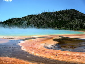
Campgrounds may fill by early morning, especially during peak season (early July - late August). Recreational vehicles over 30 ft (9.1 m) should make reservations since there is a limited number of RV sites available in Yellowstone. Large RV sites are at Flag Ranch, Fishing Bridge RV Park and West Yellowstone. Reservations should be made well in advance and/or campsites should be secured as early in the day as possible.
- Xanterra Parks & Resorts, ☏ 1 307-344-7901 (Same-day reservations), 1 307-344-7311 (Future reservations). Operates campgrounds at Bridge Bay, Canyon, Fishing Bridge, Grant Village, and Madison. Future reservations can be made by writing: Yellowstone National Park Lodges, PO Box 165, Yellowstone National Park, WY 82190.
Indian Creek, Lewis Lake, Mammoth, Norris, Pebble Creek, Slough Creek, and Tower Fall are operated by the National Park Service and do not accept reservations; all sites are first-come, first-served.
- 10 Bridge Bay Campground (on the Grand Loop Road just a few miles southwest of Lake Village and next to the Bridge Bay Marina). Open from 27-May to 18-Sep. 432 sites, flush toilets, RV dump station. Bridge Bay Campground is located at an elevation of 7,800 feet (2377 m) near Yellowstone Lake. Campers at Bridge Bay will enjoy spectacular views of the lake and the Absaroka Range rising above the lake's eastern shore. $27 per site (2020 rates).
- 11 Canyon Campground (off of the Grand Loop Road near Canyon Village). Open from 06-Jun to 11-Sep. 273 sites, showers, flush toilets. Canyon Campground is located at an elevation of 7,900 feet (2408 m) in a lodgepole pine forest at Canyon Village. $32 per site (2020 rates).
- 12 Fishing Bridge RV Park (This campground is reached by the Grand Loop Road and is near the intersection of Lake and the East Entrance road.). Closed for the entire 2020 season. (20-May to 02-Oct). 310 sites, showers, flush toilets, RV sewer station. Because grizzly bears frequent the area, no tents or tent campers are allowed. Located at an elevation of 7,800 feet (2377 m) near the Yellowstone River where it exits Yellowstone Lake. This is the only campground in Yellowstone to offer water, sewer, and electrical hookups for RVs. Campfires are prohibited in the Fishing Bridge RV Park, including the use of portable fire pits. $79 per site (2020 rates).
- 13 Grant Village Campground (south of West Thumb on the South Entrance Road). Open from 21-Jun to 02-Oct. 430 sites, showers, flush toilets, RV dump station. Grant Campground is located at an elevation of 7,800 feet (2377 m) in Grant Village, just off the Grand Loop Road at the south end of Yellowstone Lake. It is one of the larger campgrounds in the park with 430 sites. Group and wheel-chair accessible sites are available. $32 per site (2020 rates).
- 14 Indian Creek Campground (on the Grand Loop Road between Mammoth Hot Springs and Norris). Open from 10-Jun to 19-Sep. 70 sites, pit toilets. ไซต์ทั้งหมดเป็นแบบมาก่อนได้ก่อน Indian Creek Campground is located at an elevation of 7,300 feet (2225 m) near the base of the Gallatin Mountains and offers breathtaking views of Electric Peak. The campground is away from the main road and provides a quieter experience than many other locations. $15 per site (2020 rates).
- 15 Lewis Lake Campground (on the road between the South Entrance and West Thumb). Open from 17-Jun to 06-Nov. 84 sites, pit toilets. Lewis Lake Campground is located at an elevation of 7,800 ft (2377 m) a short walk from the southeast shore of Lewis Lake. $15 per site (2020 rates).
- 16 Madison Campground (This campground is reached by the Grand Loop Road and is near the intersection of the road that leads to the West Entrance. It is 14 miles east of the West Entrance and 16 miles north of Old Faithful.). Open from 06-May to 30-Oct. 278 sites, flush toilets, RV dump station. One of the most popular campgrounds in the park due to its central location and long season, Madison Campground is located at an elevation of 6,800 feet (2073 m). In spring and early summer, nearby meadows teem with wildflowers and grazing bison. In September and early October, you can often hear the bugling of bull elk. $27 per site (2020 rates).
- 17 Mammoth Campground (at Mammoth Hot Springs, five miles south of the North Entrance). 85 sites, flush toilets. ไซต์ทั้งหมดเป็นแบบมาก่อนได้ก่อน The only campground in the park open year-round, Mammoth Campground is located at an elevation of 6,200 feet (1890 m) near the park's North Entrance. Situated in a high sagebrush steppe, scattered juniper and Douglas fir trees provide shade during hot summer months. Great wildlife viewing opportunities abound with elk and bison occasionally passing through the campground. $20 per site (2020 rates).
- 18 Norris Campground (0.8 miles (1.3 km) north of Norris Junction). Open from 20-May to 26-Sep. 111 sites, flush toilets. ไซต์ทั้งหมดเป็นแบบมาก่อนได้ก่อน Situated in a lodgepole forest near the Norris Geyser Basin, Norris Campground is located at an elevation of 7,500 feet (2286 m) and is a popular destination due to its central location in the park. $20 per site (2020 rates).
- 19 Pebble Creek Campground (on the road between the North and Northeast Entrances). Open from 03-Jun to 26-Sep. 27 sites, pit toilets. ไซต์ทั้งหมดเป็นแบบมาก่อนได้ก่อน Pebble Creek Campground is located at an elevation of 6,900 feet (2103 m) and is set against the dramatic backdrop of the Absaroka Mountains near the park's Northeast Entrance, offering a more isolated camping experience. $15 per site (2020 rates).
- 20 Slough Creek Campground (5.5 miles (8.8 km) east of Tower-Roosevelt Junction, 2 miles down a dirt road). Open from 27-May to 31-Oct. 16 sites, pit toilets. Slough Creek Campground is located at an elevation of 6,250 feet (1905 m) in Lamar Valley near some of the best wildlife watching opportunities in the park. Located at the end of a two mile graded dirt road, this campground is best suited for tents and small RVs. Nighttime offers a quiet, unimpeded view of the stars and the possibility of hearing wolves howl. $15 per site (2020 rates).
- 21 Tower Fall Campground (on the road between Tower Fall and Canyon, north of Dunraven Pass and 3.5 miles (5.6 km) south of the Tower-Roosevelt Junction). Closed for the entire 2020 season. Open from 20-May to 26-Sep. 31 sites, pit toilets. ไซต์ทั้งหมดเป็นแบบมาก่อนได้ก่อน Tower Fall Campground is located at an elevation of 6,600 feet (2012 m) on the north side of the steep, winding, road to Dunraven Pass. $15 per site (2020 rates).
เขตทุรกันดาร
Permits are required for all backcountry camping, and quotas are placed on the number of people that may use an area at a given time. The maximum stay per backcountry campsite varies from 1 to 3 nights per trip. Campfires are permitted only in established fire pits, and wood fires are not allowed in some backcountry campsites. A food storage pole is provided at most designated campsites so that food and attractants may be secured from bears. Neither hunting nor firearms are allowed in Yellowstone's backcountry.
Permits may be obtained only in person and no more than 48 hours in advance of your trip, although backcountry sites may be reserved through the mail well in advance for a non-refundable $20 reservation fee. To reserve a site, download the reservation form from the Backcountry Trip Planner, call 1 307 344-2160, or by writing: Backcountry Office, PO Box 168, Yellowstone National Park, WY 82190.
During the summer season (Jun-Aug), permits are available 7 days a week between 8AM and 4:30PM at the following locations:
- Bechler Ranger Station
- Canyon Ranger Station/Visitor Center
- Grant Village Visitor Center
- สถานีเลคแรนเจอร์
- Mammoth Ranger Station/Visitor Center
- Old Faithful Ranger Station
- South Entrance Ranger Station
- Tower Ranger Station
- West Entrance Ranger Station
In addition, permits may sometimes be obtained from rangers on duty at the East Entrance and Bridge Bay Ranger Station. However, these rangers have other duties and may not be available to provide assistance at all times.
During the spring, fall, and winter seasons, ranger stations and visitor centers do not have set hours. To obtain a Backcountry Use Permit during these seasons, check the office hours posted at the nearest ranger station or visitor center.
อยู่อย่างปลอดภัย
Yellowstone has some hazards related to volcanic activity. There are also hazards from สัตว์อันตราย.
สัตว์ป่า
Though many of the animals in the park are used to seeing humans, the wildlife is nonetheless wild and should not be fed or disturbed. According to park authorities, stay at least 100 yards/meters away from bears and wolves and 25 yards/meters from all other wild animals! No matter how docile they may look, bison, elk, moose, bears, and nearly all large animals can attack. Each year, dozens of visitors are injured because they didn't keep a proper distance. สัตว์เหล่านี้มีขนาดใหญ่ เป็นสัตว์ป่า และอาจเป็นอันตรายได้ ดังนั้นจงให้พื้นที่แก่พวกมัน
In addition, be aware that odors attract bears and other wildlife, so avoid carrying or cooking odorous foods and keep a clean camp; do not cook or store food in your tent. All food, garbage, or other odorous items used for preparing or cooking food must be secured from bears. Treat all odorous products such as soap, deodorant, or other toiletries in the same manner as food. Do not leave packs containing food unattended, even for a few minutes. Animals which obtain human food often become aggressive and dependent on human foods, and many can suffer ill health or death from eating a non-native diet. A short film about food safety is now mandatory before a back country permit will be issued.
Thermal areas

It is illegal to swim or bathe in thermal pools. There is a designated swimming area along the Firehole River near Madison Junction. Always stay on boardwalks in thermal areas. Scalding water lies under thin, breakable crusts; pools are near or above boiling temperatures. Every year visitors traveling off trail are seriously burned, and people have died from the scalding water. Park rangers can also issue $130 fines for being out of bounds, or much more if there is any geological damage. Serious violations can result in the visitor being banned or the park or even facing criminal charges.
It's common to get sprayed with fine mist from the geysers, though. You don't need to worry about being burned, as the water has traveled a sufficient distance to cool down, provided you're within the designated areas. (Mist can't retain heat for more than half a second.)
Beware, glass lenses (such as eyeglasses and camera lenses) may be permanently damaged by the high mineral content of the water in the mist. For cameras, clear glass filters can provide inexpensive protection for high-priced lenses (be sure to have some replacements). If water from a thermal feature gets on a vulnerable lens, it must be washed off immediately. If no clean water is available, you can try – no, this is not a joke – licking the lens. If you try to wipe off the geyser water with a cleaning cloth (without rinsing the lens first), you risk grinding the suspended minerals into the glass of the lens, and scratching it. For eyeglasses, use safety goggles over glasses. These are quite cheap, and available at hardware stores.
ทะเลสาบเยลโลว์สโตน
This is one of the largest, high-altitude bodies of fresh water on the planet. The Lake is large enough to have its own weather effects, and conditions can change rapidly. More than a few fatalities have occurred on the lake, when boaters fell victim to weather conditions that went from calm and sunny to violent storm in a matter of minutes. East of West Thumb Geyser Basin, near Lake Village, there is a marina where boats are available for rental from a Park concessionaire.
เดินป่า
Know your 10 essentials when going on a hike, cell phones won't work in most areas of the park, and may not be depended on in an emergency situation.1. Navigation2. ความชุ่มชื้นและโภชนาการ3. มีดพก4. ป้องกันแสงแดด5. ฉนวนกันความร้อน6. Ability to make fire7. แสงสว่าง8. การปฐมพยาบาล9. ที่พักพิง10. นกหวีด
สภาพอากาศ
อากาศสามารถเปลี่ยนแปลงได้อย่างรวดเร็วและมีการเตือนเพียงเล็กน้อย A sunny, warm day can quickly become a cold, rainy or even snowy experience even in summer. ภาวะอุณหภูมิต่ำกว่าปกติอาจเป็นเรื่องที่น่ากังวล เตรียมพร้อมสำหรับสภาพอากาศที่หลากหลายโดยนำเสื้อผ้าที่เหมาะสมติดตัวไปด้วย Lightning can and does injure and kill people in the park, so watch the sky and take shelter in a building if you hear thunder. If you don't like the weather, wait 10 minutes; it'll probably change.
Other concerns
When camping, either filter, boil, or otherwise purify drinking water. Assume that even crystal clear waters may be polluted by animal and/or human wastes, and intestinal infections from drinking untreated water are increasingly common. Iodine tablets are not as effective as other methods but are readily available at local stores and easy to bring on a hike.
Finally, with so many people visiting the park each year petty crimes are something to be vigilant against. Lock your car doors and exercise sensible precautions with valuables, especially when leaving cars near trail heads or other areas where you might be away from your car for any length of time.
การบังคับใช้กฎหมาย
As a US National Park, Yellowstone is subject to US Federal Law. Generally, permits (such as for fishing) issued by surrounding States are not valid in the Park. If a visitor is cited for an offense while in the Park (such as speeding, feeding wildlife, failing to secure food in a campsite, etc), the fine ต้อง be paid immediately. The visitor is then free to make their case to the court at the Park Headquarters in Mammoth Hot Springs.
ไปต่อไป
- อุทยานแห่งชาติแกรนด์เทตัน (WY). Yellowstone's southern neighbor is famous for its dramatic mountain vistas and its alpine lakes. Admission to Grand Teton is included in the Yellowstone price. The road connecting the two parks is closed during winter (early November to mid-May).
- เวสต์เยลโลว์สโตน (MT). This town is most notable as a gateway to the park, with all the motels, services, and kitsch that park visitors require. West Yellowstone is the most convenient non-park lodging option for those planning to visit the Old Faithful area.
- การ์ดิเนอร์ (MT). Just north of the park, Gardiner is another border town that provides lodging and service options. It is the most convenient non-park option for those wanting to be near the Mammoth area of Yellowstone.
- โคดี้ (WY). About 50 miles (80 km) from the park's east entrance, this town offers a Wild West atmosphere in addition to lodging and service options. The Cody rodeo runs during the summer and the Buffalo Bill museum provides an excellent collection of old West artifacts and western art.
- เวอร์จิเนีย ซิตี้ (MT). Historical gold mining town of the old west. About 90 min from West Yellowstone, and halfway to either บัตต์ หรือ โบซแมน, มอนแทนา. In the town of Ennis, be sure to turn right at Main St. onto มอนทานา Hwy 287, and stop following the US highway of the same number.
- ไอดาโฮ. There are no roads in the small Idaho portion of the park, and very few visitors ever venture in. However, if you want to visit southern Idaho next, exit through West Yellowstone, and follow US Hwy 20. The first major city is ไอดาโฮฟอลส์ (just over 100 miles (160 km)).
| Routes through Yellowstone National Park |
| END ← | W | → โคดี้ → เชอริแดน |
| END ← | W | → โคดี้ → ควาย |
| ไอดาโฮฟอลส์ ← เวสต์เยลโลว์สโตน ← | W | → โคดี้ → แคสเปอร์ |
| ลิฟวิงสตัน ← การ์ดิเนอร์ ← | นู๋ | → Grand Teton N.P. → โลแกน |
| โบซแมน ← เวสต์เยลโลว์สโตน ← | นู๋ | → Grand Teton N.P. → ร็อคสปริงส์ |
| END ← | W | → เมืองคุก → บิลลิงส์ |
| เฮเลนา ← เวสต์เยลโลว์สโตน ← | นู๋ | → Grand Teton N.P. → รอว์ลินส์ |