คู่มือการดำน้ำระดับภูมิภาคนี้จัดทำขึ้นเพื่อให้มีคุณสมบัติ นักประดาน้ำ พร้อมข้อมูลที่จะช่วยวางแผนการดำน้ำในน่านน้ำของ Cape Peninsula และ False Bay ไม่ว่าจะเป็นผู้อาศัยในท้องถิ่นหรือผู้มาเยือน ข้อมูลถูกจัดเตรียมโดยไม่มีอคติ และไม่รับประกันความถูกต้องหรือสมบูรณ์ ใช้ความเสี่ยงของคุณเอง ขยายหรือแก้ไขเมื่อทำได้
ภูมิภาคที่อธิบายอยู่ภายในการเดินทางหนึ่งวันโดยทางถนนจากส่วนใดส่วนหนึ่งของเมือง เคปทาวน์, ใน เวสเทิร์นเคป จังหวัดของ แอฟริกาใต้ และรวมแหล่งดำน้ำที่มีชื่อมากกว่า 280 แห่งซึ่งมีการบันทึกตำแหน่งไว้ ซึ่งมากสำหรับจุดหมายปลายทางแห่งเดียว
ข้อมูลโดยละเอียดเกี่ยวกับแหล่งดำน้ำแต่ละแห่งมีอยู่ในบทความย่อยที่เชื่อมโยงจาก จุดดำน้ำ มาตรา. ข้อมูลในคำอธิบายไซต์มีตั้งแต่ผิวเผินไปจนถึงรายละเอียดสูง ขึ้นอยู่กับสิ่งที่ทราบเกี่ยวกับไซต์ อาจจะมีแผนที่ แผนภูมิ Bathymetric โดย SURGMAP ได้รับการอัปเดตเมื่อมีการรวบรวมข้อมูลการสำรวจใหม่ และทำแผนที่โดยการว่ายน้ำรูปทรงที่ลากทุ่น GPS มีความแม่นยำพอสมควร - โดยปกติภายในสองสามเมตร - และเชื่อถือได้สำหรับสิ่งที่แสดง แต่ไม่ค่อยสมบูรณ์ เป็นไปได้มากทีเดียวที่ยอดแหลมสูงบางอันอาจพลาดพลั้งไป ไม่มีการรับประกันว่าคุณจะไม่ค้นพบมันด้วยเรือของคุณ หากคุณทำโปรดแจ้งให้เราทราบ
ในบางกรณี บทความย่อยของไซต์ดำน้ำจะประกอบด้วยไซต์หลายแห่งที่อยู่ใกล้กัน เนื่องจากข้อมูลส่วนใหญ่จะมีอยู่ทั่วไปสำหรับไซต์เหล่านี้ทั้งหมด ในกรณีอื่นๆ ซึ่งมักจะเกี่ยวข้องกับจุดอับปาง ไซต์สองแห่งที่อยู่ติดกันแต่ละแห่งจะมีบทความย่อยของตัวเอง แต่ถ้าซากสองชิ้นขึ้นไปอยู่ในตำแหน่งเดียวกัน หรือมีการทับซ้อนกันอย่างมาก จะมีการอธิบายไว้ในบทความย่อยเดียวกัน
เข้าใจ


ภูมิประเทศทั่วไป
เมืองเคปทาวน์ก่อตั้งขึ้นที่ตอนเหนือสุดของ แหลมคาบสมุทรเป็นแถบภูเขาแคบๆ กว้างที่สุด 11 กม. และยาวเพียง 50 กม. พรมแดนด้านเหนือคือชายฝั่งอ่าวเทเบิ้ล ซึ่งเป็นอ่าวเปิดขนาดใหญ่ที่มีเกาะเพียงเกาะเดียว เกาะร็อบเบิน, ในปากของมัน.
ชายฝั่งทะเลที่ขรุขระเป็นแนวพรมแดนด้านตะวันตกของมหาสมุทรแอตแลนติก มีอ่าวเล็ก ๆ หลายแห่งตามชายฝั่งโดยมีอ่าวใหญ่เพียงแห่งเดียว เฮาท์เบย์ประมาณครึ่งทาง ไกลออกไปทางใต้ คาบสมุทรจะแคบลงจนถึงจุดสิ้นสุดที่ Cape Point เทือกเขาที่มีเทือกเขาเทเบิลอยู่ที่ 1,085 ม. ทางตอนเหนือสุดเป็นกระดูกสันหลังของคาบสมุทร จุดสูงสุดของคาบสมุทรทางใต้คือ Swartkop ที่ความสูง 678 ม. ใกล้เมืองไซม่อน คาบสมุทรมีความลาดชันค่อนข้างสูงตลอดแนวชายฝั่ง โดยมีพื้นที่แคบมากซึ่งค่อนข้างราบเรียบ ยกเว้นด้านตะวันตกของปลายด้านใต้
ฝั่งตะวันออกที่สูงชันล้อมรอบด้วย False Bay และแนวชายฝั่งที่ทอดยาวนี้รวมถึงอ่าว Smitswinkel ที่เล็กกว่า อ่าว Simon และอ่าว Fish Hoek ที่มีแถบพื้นดินต่ำทอดยาวระหว่างชายฝั่งทั้งสองฝั่ง ที่มุยเซนแบร์ก ชายฝั่งทะเลจะค่อนข้างต่ำและเป็นทราย และโค้งไปทางทิศตะวันออกข้ามพรมแดนด้านใต้ของ Cape Flats สู่อ่าวกอร์ดอนเพื่อสร้างพรมแดนด้านเหนือของอ่าวเท็จ จาก กอร์ดอนส์เบย์ แนวชายฝั่งแกว่งไปทางใต้ประมาณ และซิกแซกไปตามเชิงเขาฮอลแลนด์ของ Hottentot ไปจนถึง Cape Hangklip ซึ่งใกล้เคียงกับละติจูดเกือบเท่ากับ Cape Point ยอดเขาที่สูงที่สุดด้านนี้คือ Kogelberg ที่ 1,269 ม.
ในแผนผัง อ่าวนี้มีขนาดประมาณสี่เหลี่ยมจัตุรัสและมีขอบค่อนข้างสั่น โดยมีขนาดเท่ากันจากเหนือจรดใต้กับตะวันออกไปตะวันตก (30 กม.) โดยด้านใต้ทั้งหมดเปิดออกสู่มหาสมุทร วัดพื้นที่ False Bay ที่ประมาณ 1,090 km² และปริมาตรประมาณ 45 km³ (ความลึกเฉลี่ยประมาณ 40 m) วัดปริมณฑลของแผ่นดินที่ 116 กม. จากแผนที่มาตราส่วน 1:50,000
ลักษณะทางสัณฐานวิทยาด้านล่างของอ่าวเท็จโดยทั่วไปจะราบเรียบและค่อนข้างตื้น โดยลาดลงจากเหนือจรดใต้เบาๆ เพื่อให้ความลึกตรงกลางปากประมาณ 80 เมตร ด้านล่างปกคลุมไปด้วยตะกอนซึ่งมีตั้งแต่หยาบมากไปจนถึงละเอียดมาก โดยมีตะกอนละเอียดและโคลนส่วนใหญ่อยู่ตรงกลางอ่าว ข้อยกเว้นหลักคือแนวหินตะกอนยาวที่ทอดตัวไปทางทิศใต้จากนอกชายฝั่งไปจนถึงระดับประมาณกับปากแม่น้ำสตีนบราส ปลายด้านใต้ของสันเขานี้เรียกว่า Steenbras Deep
ในอ่าวมีเกาะจริงอยู่เกาะหนึ่งคือ เกาะแมวน้ำ ซึ่งเป็นหินแกรนิตที่แห้งแล้งและเป็นหิน ยาวประมาณ 200 ม. และมีพื้นที่ประมาณ 2 เฮกตาร์ อยู่ห่างจาก Strandfontein ไปทางใต้ประมาณ 6 กม. และสูงกว่าระดับน้ำทะเลไม่ถึง 10 เมตรที่จุดสูงสุด นอกจากนี้ยังมีเกาะหินเล็กๆ จำนวนมากที่ทอดตัวเหนือระดับน้ำสูง และมีโขดหินและสันดอนอื่นๆ ที่เข้าใกล้ผิวน้ำ ส่วนใหญ่เป็นหินแกรนิตของ คาบสมุทร พลูตอน แต่ทางตะวันออกของเกาะซีล โดยทั่วไปแล้วจะเป็นหินทราย น่าจะเป็นของ Tygerberg ก่อตัวขึ้นภายในอ่าว แม้ว่าจะเป็นไปได้ว่าบางส่วนอาจเป็นของ ภูเขาเทเบิล ชุด. พื้นที่แนวปะการังที่ใหญ่ที่สุดคือ Whittle Rock ซึ่งเป็นเนินหินแกรนิตใต้น้ำที่โผล่ขึ้นมาจากพื้นทรายที่ความสูงประมาณ 40 ม. ถึงภายใน 5 ม. ของพื้นผิว และมีเส้นผ่านศูนย์กลางประมาณ 1 กม.
นอกอ่าวแต่มีอิทธิพลต่อรูปแบบคลื่นในนั้นคือ Rocky Bank ซึ่งเป็นแนวปะการังที่กว้างขวางของ ภูเขาเทเบิล แนวหินทรายที่มีความลึกระหว่าง 20 ถึง 30 ม. และลาดลงไปทางใต้ลึกกว่า 100 ม.
พูดอย่างเคร่งครัด False Bay เป็นส่วนหนึ่งของมหาสมุทรแอตแลนติกซึ่งขยายไปถึง Cape Agulhas แต่เมื่ออยู่ใน Cape Town แอตแลนติกโดยทั่วไปหมายถึงชายฝั่งตะวันตกของ Cape Peninsula และฝั่งตะวันออกเรียกว่า False Bay หรือ ทางด้านไซม่อนทาวน์ แบบแผนนี้จะถูกนำมาใช้ตลอดทั้งคู่มือนี้
ภูมิประเทศในท้องถิ่น
อิทธิพลที่แข็งแกร่งที่สุดต่อภูมิประเทศในท้องถิ่นคือธรณีวิทยาในท้องถิ่น ตะกอนทรายหรือกรวดที่ไม่เป็นเนื้อเดียวกันมักจะค่อนข้างแบน หินกรวดและก้อนหินขนาดเล็กอาจลาดเอียงมากขึ้น ส่วนหินและก้อนหินขนาดใหญ่อาจเป็นอะไรก็ได้ตั้งแต่ยกขึ้นเหนือก้นที่ไม่เรียงกันโดยรอบเล็กน้อย ไปจนถึงหน้าผาที่ยื่นออกมาและส่วนโค้ง ประเภทของหิน และสำหรับชั้นตะกอน การจุ่มและการกระแทก มีอิทธิพลอย่างมากต่อช่วงของรูปแบบแนวปะการังที่เป็นไปได้
โครงสร้างแนวปะการังในปัจจุบันพัฒนาเป็นธรณีสัณฐานในยุคน้ำแข็ง เมื่อพวกมันอยู่เหนือระดับน้ำทะเล และแนวปะการังหินแกรนิตส่วนใหญ่มีรูปร่างโดยกระบวนการผุกร่อนใต้ดินในช่วงเวลาที่ยาวนานกว่านั้น หินแกรนิตค่อนข้างเก่า และถูกเชื่อมเข้าด้วยกันโดยแรงแปรสัณฐาน และขอบของรอยแตกนั้นใช้เวลานานมากที่จะถูกน้ำบาดาลกัดเซาะทางเคมีเพื่อปัดเศษออกจนเกิดเป็นร่องลึกและลำธาร ซึ่งต่อมาถูกเปิดเผยโดยการกัดเซาะ ของ saprolith และดัดแปลงเพิ่มเติมโดยสภาพดินฟ้าอากาศและการพังทลายของพื้นผิวที่เปิดเผยต่อโครงสร้างที่เรียกว่า corestones และ tors ในทำนองเดียวกัน หินตะกอนที่โผล่ออกมากัดเซาะในขณะที่โผล่พ้นเหนือพื้นดิน เมื่อระดับน้ำทะเลสูงขึ้นในระหว่างการละลายของน้ำแข็ง ธรณีสัณฐานเหล่านี้จะท่วมท้น และคงไว้ซึ่งรูปแบบและลักษณะเดิมส่วนใหญ่ การกัดเซาะชายฝั่งตั้งแต่นั้นมามีการปรับเปลี่ยนแนวปะการังในพื้นที่ที่สัมผัสกับคลื่นพลังงานสูงเพียงพอ และการเคลื่อนที่ของตะกอนบางส่วนเกิดขึ้นเนื่องจากคลื่นและกระแสน้ำ
สภาพภูมิอากาศ สภาพอากาศ และสภาพทะเล

ภูมิอากาศของแหลมตะวันตก
สภาพภูมิอากาศของแหลมตะวันตกเฉียงใต้มีความแตกต่างอย่างเห็นได้ชัดจากส่วนอื่นๆ ของแอฟริกาใต้ ซึ่งเป็นพื้นที่ที่มีฝนตกชุกในฤดูร้อน โดยได้รับปริมาณน้ำฝนมากที่สุดในช่วงฤดูร้อนของเดือนธันวาคมถึงกุมภาพันธ์ แหลมตะวันตกเฉียงใต้มีภูมิอากาศแบบเมดิเตอร์เรเนียน โดยมีฝนตกมากที่สุดในช่วงฤดูหนาวตั้งแต่เดือนมิถุนายนถึงกันยายน
ในช่วงฤดูร้อน ปัจจัยสำคัญที่กำหนดสภาพอากาศในภูมิภาคนี้คือเขตความกดอากาศสูงที่เรียกว่าแอตแลนติกไฮ (Atlantic High) ซึ่งอยู่เหนือมหาสมุทรแอตแลนติกใต้ทางตะวันตกของชายฝั่งเคป ลมที่หมุนเวียนในทิศทางทวนเข็มนาฬิกาจากระบบดังกล่าวไปถึงแหลมจากทางตะวันออกเฉียงใต้ ทำให้เกิดลมแรงและท้องฟ้าแจ่มใสเป็นช่วงสูงสุดเป็นเวลาหลายวัน ลมตะวันออกเฉียงเหนือเหล่านี้รู้จักกันในชื่อ Cape Doctor พวกเขาทำให้ภูมิภาคนี้ค่อนข้างเย็นและช่วยพัดอากาศเสียจากพื้นที่อุตสาหกรรมและ Cape Flats ออกสู่ทะเล เนื่องจากด้านทิศใต้ของอ่าว False Bay จึงเปิดรับลมเหล่านี้ โดยเฉพาะอย่างยิ่งทางฝั่งตะวันตก ในขณะที่ Table Bay และชายฝั่งตะวันตกของคาบสมุทรประสบกับลมนอกชายฝั่ง ลมรูปแบบนี้ได้รับอิทธิพลจากภูมิประเทศในขอบเขตที่ลมแรงพายุอาจจะพัดเข้ามา อ่าวกอร์ดอน , ในขณะที่ห่างออกไปประมาณ 10 กม.บางส่วนของ ซัมเมอร์เซ็ท เวสต์ อาจมีวันที่ร้อนอบอ้าวและไม่มีลม
ฤดูหนาวในแหลมตะวันตกเฉียงใต้มีลักษณะพิเศษคือมีคลื่นลมตะวันตกเฉียงเหนือทำให้เกิดกระแสลมหมุนวนรอบทิศตะวันออก ทำให้มีอากาศเย็น มีลมและฝนพัดมาจากทิศตะวันตกเฉียงเหนือ ตามด้วยอุณหภูมิที่ลดลงและลมตะวันตกเฉียงใต้จะพัดเข้าสู่ช่วงหน้า ลมตะวันตกเฉียงใต้ที่พัดผ่านมหาสมุทรแอตแลนติกใต้ทำให้เกิดคลื่นลมตะวันตกเฉียงใต้โดยทั่วไปของเดือนในฤดูหนาว ซึ่งพัดกระทบชายฝั่งมหาสมุทรแอตแลนติกที่เปิดโล่งและด้านตะวันออกของอ่าวเท็จ ภูเขาของแหลมคาบสมุทรให้ความคุ้มครองภายในฝั่งตะวันตกของอ่าวเท็จจากลมนี้และจากคลื่นตะวันตกเฉียงใต้ - ข้อเท็จจริงที่มีอิทธิพลต่อผู้ว่าการ Simon van der Stel ในการเลือกอ่าวไซมอนเป็นท่าเรือฤดูหนาวสำหรับ บริษัท Dutch East India เรือสำหรับเคปทาวน์ พายุฤดูหนาวทางตะวันตกเฉียงเหนือได้ทำลายเรือหลายลำที่ทอดสมออยู่ในอ่าวเทเบิลตลอดหลายศตวรรษที่ผ่านมา แม้ในปัจจุบันนี้ แม้จะมีความก้าวหน้าทางเทคนิคและการพยากรณ์อากาศที่ดีขึ้นก็ตาม เรื่องนี้ก็ยังเกิดขึ้น แม้ว่าจะไม่ค่อยบ่อยเท่าในอดีต และทุกวันนี้ การดำเนินการกอบกู้กลับประสบความสำเร็จมากกว่า
สภาพอากาศ
แนวโน้มโดยทั่วไปคือสภาพอากาศจะเข้ามาทางทิศตะวันตกและเคลื่อนตัวไปทางทิศตะวันออกด้วยระบบด้านหน้า แต่อาจมีปรากฏการณ์สภาพอากาศในท้องถิ่นเพิ่มเติม เช่น พายุฝนฟ้าคะนอง (หายาก) และลม 'เบิร์ก' ซึ่งเป็นลมอุ่นพัดผ่าน ภูเขาจากภายใน อาจมีความแตกต่างกันมากในสภาพอากาศระหว่างสถานที่ต่างๆ ในพื้นที่ที่คู่มือนี้ครอบคลุมทุกวัน แม้ว่าแนวโน้มโดยทั่วไปอาจคล้ายคลึงกัน ตัวอย่างเช่น ฝนอาจตกลงมาบนคาบสมุทรเคปในตอนเช้า และในช่วงบ่าย สภาวะเหล่านี้อาจเคลื่อนไปทางด้านตะวันออกของอ่าวเท็จ และคาบสมุทรอาจจะปลอดโปร่งโดยมีทิศทางลมเปลี่ยนทิศทางอย่างมีนัยสำคัญจากทิศตะวันตกเฉียงเหนือเป็นทิศตะวันตกเฉียงใต้ ความแปรปรวนของแรงลมในท้องถิ่นอาจรุนแรงมาก และบางครั้งก็ยากจะเชื่อ เนื่องจากอาจมีความสงบในที่เดียวและลมที่หอนอยู่ห่างออกไปสองสามกิโลเมตร มีสถานที่ซึ่งขึ้นชื่อจากลมตะวันออกเฉียงใต้และลมตะวันตกเฉียงเหนือ และบางแห่งมีที่กำบังจากที่อื่น ในขณะที่ทางตะวันตกเฉียงใต้พัดสถานที่ส่วนใหญ่ แต่โดยปกติแล้วจะไม่ถึงระดับสุดโต่งเท่าๆ กัน ในทางปฏิบัติ จำนวนนี้เท่ากับว่าสภาพอากาศที่คุณอยู่ในช่วงเวลาใดเวลาหนึ่งอาจแตกต่างอย่างมากจากที่จุดดำน้ำในตอนกลางวันเล็กน้อย
ลมภูเขาหิมะเกิดจากความกดอากาศสูงภายในประเทศที่ระดับความสูงสูง โดยปกติในฤดูหนาว บริเวณที่ราบสูงตอนกลางที่อากาศหนาวเย็นและแห้งแล้งตอนกลางเหนือที่ราบสูงใหญ่ ประกอบกับความกดอากาศต่ำที่ชายฝั่ง ลมที่พัดลงมาตามที่สูงชันและถูกทำให้ร้อนด้วยแรงอัด อุณหภูมิจะสูงขึ้นอย่างมากและในช่วงเวลาสั้นๆ ลมร้อนและแล้งนี้อยู่นอกชายฝั่งและไม่กระทบต่อสภาพการดำน้ำมากนัก แต่โดยทั่วไปแล้วลมบนบกจะมีอากาศเย็น โดยมีเมฆน้อย มีหมอก และมีฝนละออง และมักเกี่ยวข้องกับแนวหน้าเย็นจากตะวันตกในฤดูหนาว ซึ่ง อาจมีลมตะวันตกมีกำลังแรงและมีฝนหนักที่ส่วนหน้า
สภาพทะเล
คลื่นและบวม
คลื่นที่ไปถึงชายฝั่งของ False Bay และ Cape Peninsula ถือได้ว่าเป็นคลื่นลมในท้องถิ่นและการบวมจากแหล่งที่อยู่ห่างไกล อาการบวมเกิดจากระบบสภาพอากาศโดยทั่วไปทางตอนใต้ของทวีป ซึ่งบางครั้งอาจห่างไกลมาก ที่สำคัญที่สุดคือระบบหน้าผากในมหาสมุทรแอตแลนติกใต้ ซึ่งสร้างคลื่นลมซึ่งจากนั้นจะกระจายออกจากแหล่งกำเนิดและแยกออกเป็นโซนต่างๆ ตามกาลเวลา ระยะเวลา คลื่นคาบยาวจะเร็วกว่าและมีพลังงานมากกว่า และเคลื่อนไปข้างหน้าขององค์ประกอบที่มีคาบเวลาสั้นกว่า ดังนั้นพวกมันจึงมักจะไปถึงชายฝั่งก่อน นักเล่นกระดานโต้คลื่นรู้กันดีว่าเป็นชีพจร และโดยทั่วไปแล้วจะค่อยๆ ลดระยะเวลาบวมขึ้นโดยใช้พลังงานน้อยลง
ลมในท้องถิ่นจะทำให้เกิดคลื่นซึ่งจะรวมผลกระทบกับคลื่น ลมนอกชายฝั่งตามกฎทั่วไปจะทำให้ทะเลราบเรียบเนื่องจากระยะห่าง (ระยะทางที่ลมพัดเหนือน้ำ) มักมีขนาดเล็กเกินไปที่จะทำให้เกิดคลื่นสูงหรือยาวมาก ในทางกลับกัน ลมบนบก หากแรงเพียงพอจะทำให้เกิดการตัดสั้นและน่ารังเกียจ ซึ่งทำให้การเข้าออกไม่สะดวก และการว่ายน้ำบนพื้นผิวหรือการล่องเรือไม่เป็นที่น่าพอใจ
ต้องพิจารณาการรวมกันของคลื่นและคลื่นลมเมื่อวางแผนดำน้ำ สิ่งนี้ต้องการความรู้เกี่ยวกับเงื่อนไขเหล่านี้ ซึ่งคาดการณ์ด้วยความแม่นยำที่แปรผันโดยหลายองค์กร ในบางกรณีเป็นเวลาเจ็ดวันหรือมากกว่านั้น ความแม่นยำโดยทั่วไปแปรผกผันกับช่วงเวลาของการพยากรณ์ โดยปกติแล้วจะค่อนข้างน่าเชื่อถือเมื่อมองไปข้างหน้าสองหรือสามวัน แต่อาจสั่นคลอนเล็กน้อยในมากกว่าหนึ่งสัปดาห์ อากาศเป็นเช่นนั้น
อัพเวลลิงส์
ลมตะวันออกเฉียงใต้ที่พัดนอกชายฝั่งและตามแนวชายฝั่งทางฝั่งตะวันตกของคาบสมุทรเคปและทางด้านตะวันออกของอ่าวเท็จ ทำให้เกิดการเคลื่อนตัวของน้ำผิวดินนอกชายฝั่งไปทางตะวันตกของชายฝั่งอันเนื่องมาจากการขนส่งเอกมาน การเคลื่อนตัวของน้ำออกจากชายฝั่งนี้ได้รับการชดเชยด้วยการขึ้นที่สูงของน้ำที่ลึกกว่า
แหล่งน้ำขึ้นสูงเหล่านี้เป็นที่สนใจของนักประดาน้ำเป็นอย่างมาก เนื่องจากน้ำที่ท่วมบนชายฝั่งตะวันตกนั้นเย็นและค่อนข้างใส อย่างไรก็ตาม เนื่องจากน้ำที่ท่วมขังมีปริมาณสารอาหารสูง การเพิ่มจำนวนขึ้นจึงมักเป็นบรรพบุรุษของแพลงก์ตอนบานที่รู้จักกันในชื่อ "กระแสน้ำสีแดง" ซึ่งจะทำให้ทัศนวิสัยลดลงอย่างมาก อุณหภูมิของน้ำมีแนวโน้มลดลงเหลือต่ำกว่า 12°C ในช่วงที่มีน้ำขึ้นสูงในชายฝั่งตะวันตก และอาจถึง 7°C ที่หนาวเย็นในบางครั้ง
ทางด้านตะวันออกของอ่าวเท็จ กระแสน้ำขึ้นสูงมักทำให้ทัศนวิสัยไม่ดี เนื่องจากสามารถรบกวนตะกอนที่มีความหนาแน่นต่ำและละเอียดมาก ซึ่งพบได้ทั่วไปที่ด้านข้างของอ่าว โดยเฉพาะอย่างยิ่งในส่วนที่ตื้นกว่าใกล้กับอ่าวกอร์ดอน น้ำยังค่อนข้างเย็น แต่โดยปกติแล้วจะไม่เย็นเท่าทางฝั่งตะวันตกของคาบสมุทร และอุณหภูมิอาจลดลงจากประมาณ 19°C ถึง 12°C ในหนึ่งหรือสองวัน
กระแสน้ำ
กระแสน้ำในท้องถิ่นมีดวงจันทร์ครอบงำ ครึ่งวัน และค่อนข้างอ่อน และไม่มีกระแสน้ำขึ้นน้ำลงอย่างแรงบนชายฝั่งมหาสมุทรแอตแลนติกหรือในอ่าวเท็จ กระแสน้ำที่เกิดขึ้นมีผลเพียงเล็กน้อยต่อนักประดาน้ำ ผลกระทบหลักคือการเปลี่ยนแปลงเล็กน้อยในความลึกที่จุดดำน้ำ และการเปลี่ยนแปลงของสิ่งกีดขวางที่เกิดจากสาหร่ายเคลป์ใกล้ผิวน้ำ ซึ่งอาจส่งผลต่อความพยายามที่จำเป็นในการผ่านสาหร่ายทะเลที่ พื้นผิว. ในเรื่องนี้จะง่ายกว่าเมื่อน้ำขึ้น
การปล่อยเรือที่ทางลื่นบางทางอาจทำได้ยากในช่วงน้ำลง ซึ่งอาจส่งผลต่อตารางการดำน้ำในบางครั้ง และระยะสปริงโลว์อยู่ที่เวลาโดยประมาณของการเปิดตัวครั้งแรก (ประมาณ 09:00 ถึง 09:30 น.)
ช่วงกระแสน้ำสูงสุดที่เคปทาวน์อยู่ที่ประมาณ 1.86 ม. (กระแสน้ำในฤดูใบไม้ผลิ) และที่ไซม่อนทาวน์ 1.91 ม. โดยมีช่วงต่ำสุดที่ทั้งสองแห่งประมาณ 0.26 ม. (กระแสน้ำไหลย้อนกลับ)
อุณหภูมิของน้ำ
อุณหภูมิพื้นผิวฤดูร้อนเฉลี่ยของมหาสมุทรแอตแลนติกนอกคาบสมุทรเคปอยู่ในช่วง 10 ถึง 13 องศาเซลเซียส อุณหภูมิด้านล่างอาจเย็นกว่าสองสามองศา อุณหภูมิต่ำสุดอยู่ที่ประมาณ 8°C แม้ว่าจะมีการอ้างว่ามีอุณหภูมิต่ำถึง 6° และสูงสุดประมาณ 17°C
อุณหภูมิพื้นผิวเฉลี่ยในฤดูหนาวของมหาสมุทรแอตแลนติกนอกคาบสมุทรเคปอยู่ในช่วง 13° ถึง 15°C อุณหภูมิด้านล่างฝั่งก็ใกล้เคียงกันมาก
อุณหภูมิพื้นผิวเฉลี่ยในฤดูหนาวของ False Bay อยู่ที่ประมาณ 15 °C และอุณหภูมิด้านล่างเท่าเดิมหรือต่ำกว่านั้นเล็กน้อย อุณหภูมิพื้นผิวฤดูร้อนเฉลี่ยของ False Bay อยู่ที่ประมาณ 19 °C อุณหภูมิด้านล่างโดยทั่วไปจะต่ำกว่าฤดูหนาว 1° ถึง 3°C แต่ไม่ทราบอุณหภูมิ 10° ถึง 12°C
กระแสน้ำ
กระแสน้ำมักไม่ถือว่าเป็นปัญหาในแหล่งดำน้ำส่วนใหญ่ในภูมิภาคนี้ กระแสน้ำที่ผิวน้ำตื้นอาจเกิดจากลมแรงในช่วงเวลาสั้นๆ ซึ่งอาจสร้างความไม่สะดวกหากเคลื่อนตัวออกนอกชายฝั่ง ความลึกของกระแสน้ำขึ้นอยู่กับระยะเวลาที่ลมพัด และเมื่อลมพัดมาขณะกำลังดำน้ำ กระแสน้ำจะตื้นและนักประดาน้ำอาจกลับขึ้นฝั่งที่ระดับความลึก 3 ถึง 6 เมตรต่ำกว่ากระแสน้ำส่วนใหญ่ กระแสน้ำขึ้นน้ำลงเล็กน้อย และมีประสบการณ์เฉพาะในแหล่งดำน้ำบางแห่งเท่านั้น เช่น หาดวินด์มิลล์, ในช่วงน้ำขึ้นน้ำลงเมื่อมีกระแสน้ำไหลเชี่ยวบ้าง. พึงระลึกไว้เสมอว่ากระแสลมที่พื้นผิวขับเคลื่อนโดยลมจะไหลไปทางซ้ายของทิศทางลมเนื่องจากผลกระทบของโบลิทาร์ และมุมจะเพิ่มขึ้นและความแรงจะลดลงตามความลึก
สถานที่สองแห่งที่อาจประสบกระแสน้ำสำคัญอยู่ที่ปากอ่าวเท็จที่ ร็อคกี้ แบงค์ และ Bellows Rockที่ซึ่งกระแสน้ำวนจากกระแสน้ำ Agulhas มักสร้างกระแสไฟที่มีกำลังเบาถึงปานกลาง ซึ่งอาจแรงพอที่จะทำให้นักดำน้ำไม่สะดวกในบริเวณน้ำตื้นรอบๆ ก้อนหิน Bellows กระแสน้ำที่สูงถึงประมาณหนึ่งปมเกิดขึ้นที่แหล่งดำน้ำนอกชายฝั่งเป็นเท็จในบางครั้ง อ่าวทางตอนใต้ของ Simon's Town และบนชายฝั่งมหาสมุทรแอตแลนติกใกล้ Duiker Point และเกาะ Robben กระแสน้ำเหล่านี้มักจะอ่อนลงอย่างมากที่ด้านล่าง และโดยปกติไม่ค่อยทำให้นักดำน้ำลำบากมากนัก แม้ว่าพวกเขาจะใช้ DSMB สำหรับพื้นผิวที่สำคัญกว่า เนื่องจากสามารถล่องลอยไปได้ไกลแม้บนทางขึ้นปกติโดยมีการหยุดแบบปลอดภัย . กระแสน้ำบนพื้นผิวเหล่านี้อาจสร้างความไม่สะดวกมากขึ้นในช่วงเริ่มต้นของการดำน้ำ เนื่องจากกระแสน้ำจะพาคุณผ่านเส้นช็อตไลน์ถ้าคุณไม่พร้อมท์เกี่ยวกับการลง ซึ่งควรทำทันทีที่มองเห็นเส้น นอกจากนี้ยังขึ้นอยู่กับระยะหย่อนในช็อตไลน์ด้วย ทุ่นจะอยู่ตามลมและตามกระแสน้ำของเครื่องหมายหลายเมตร กัปตันที่มีความสามารถจะยอมให้เงินบางส่วนและปล่อยนักประดาน้ำที่ต้นน้ำของทุ่น
ข้อมูลสภาพอากาศ
มีข้อมูลสภาพอากาศตามเวลาจริงสำหรับ False Bay จากa ทุ่นอากาศ ดำเนินการโดยศูนย์สังเกตการณ์สมุทรศาสตร์ ข้อมูลปัจจุบันและข้อมูลย้อนหลัง 7 วันจะแสดงขึ้นสำหรับอุณหภูมิพื้นผิวอากาศและน้ำทะเล ความแรงและทิศทางของลม และความกดอากาศ ตำแหน่งของทุ่นอาจแตกต่างกัน แต่เมื่อเดือนตุลาคม 2555 อยู่ที่ 34°11'19"S, 18°27'03"E (ประมาณ 700 ม. ทางตะวันออกของท่าเรือ Simon's Town)
การทำนายสภาพอากาศและสภาพทะเล
การคาดการณ์สภาพการดำน้ำในภูมิภาคนี้ค่อนข้างซับซ้อน มีเว็บไซต์เช่น ทุ่นสภาพอากาศ, ท่องพยากรณ์ และ วินด์คุรุ ซึ่งให้การคาดการณ์ที่เชื่อถือได้พอสมควรสำหรับลมและบวม เมื่อรวมกับข้อมูลเกี่ยวกับสภาพปัจจุบันของอุณหภูมิน้ำและทัศนวิสัยจะช่วยให้สามารถคาดการณ์สภาวะล่วงหน้าได้อย่างน่าเชื่อถือล่วงหน้าสองสามวัน ท้องถิ่น Wavescape รายงานเว็บไซต์และเซิร์ฟยังเป็นข้อมูลอ้างอิงที่มีค่าด้วยบรรยากาศที่โดดเด่นของแอฟริกาใต้ แม้ว่าจะเหมือนกับรายงานอื่นๆ ที่มีไว้สำหรับนักเล่นเซิร์ฟเป็นหลัก และนักดำน้ำต้องสอดแทรกเล็กน้อย
การมองเห็นสามารถชัดเจนขึ้นอย่างรวดเร็ว (ข้ามคืน) บนชายฝั่งมหาสมุทรแอตแลนติกเนื่องจากกระแสน้ำและตะกอนที่ค่อนข้างหยาบ ทางฝั่งตะวันตกของอ่าวเท็จจะช้ากว่าเล็กน้อย และอาจใช้เวลาหลายวันหรือหลายสัปดาห์ทางฝั่งตะวันออกของอ่าว ซึ่งตะกอนจะละเอียดและเบา
อุณหภูมิพื้นผิวทะเลจากดาวเทียมและข้อมูลคลอโรฟิลล์ยังมีอยู่บนอินเทอร์เน็ต และอาจช่วยทำนายสภาพพื้นผิวได้ แต่ไม่ทราบอุณหภูมิพื้นผิวทะเลที่คาดการณ์ได้มากน้อยเพียงใด
จนกว่าคุณจะได้พัฒนาความรู้สึกสำหรับขั้นตอนนี้ จะเป็นประโยชน์ในการขอความคิดเห็นจากบุคคลหรือองค์กรที่มีประสบการณ์
ผู้ให้บริการเช่าเหมาลำดำน้ำในท้องถิ่นบางรายมีชื่อเสียงในการพยากรณ์อากาศได้ดีกว่าบริษัทอื่น และมีบางคนที่มักจะอ้างว่าสภาพอากาศดีหรือดี บลูแฟลช จดหมายข่าวรายสัปดาห์นั้นดีพอๆ กับที่อื่นๆ และดีกว่ามากมาย นี่จะหมายถึงพื้นที่ที่ต้องการนอก Cape Peninsula รวมถึงฝั่งตะวันตกของ False Bay สำหรับข้อมูลเกี่ยวกับฝั่งตะวันออกของ False Bay คุณสามารถลองโทรติดต่อ Indigo Divers
นิเวศวิทยาทางทะเล

ไบโอรีเจียนส์
Cape Point ที่ปลายแหลม Cape Peninsula ถือเป็นเขตแดนระหว่างสองในห้า bioregions ทางทะเลของแอฟริกาใต้ ทางทิศตะวันตกของ Cape Point คือบริเวณชายฝั่งทางตะวันตกเฉียงใต้ของ Cape Point ที่มีอากาศเย็นถึงเย็น และทางทิศตะวันออกจะเป็น Agulhas ที่มีอากาศอบอุ่นในชายฝั่ง bioregion การแตกหักของ Cape Point ถือเป็นการเปลี่ยนแปลงที่ค่อนข้างชัดเจนใน bioregions และสามารถมองเห็นได้ชัดเจนจากความแตกต่างของสิ่งมีชีวิตในทะเลระหว่างชายฝั่งมหาสมุทรแอตแลนติกของคาบสมุทรและ False Bay
ที่อยู่อาศัย
แหล่งที่อยู่อาศัยหลักสี่แห่งมีอยู่ในทะเลในภูมิภาคนี้ ซึ่งแตกต่างไปตามธรรมชาติของพื้นผิว สารตั้งต้นหรือวัสดุฐานมีความสำคัญในการเป็นฐานที่สิ่งมีชีวิตสามารถยึดตัวเองได้ ซึ่งมีความสำคัญอย่างยิ่งต่อสิ่งมีชีวิตเหล่านั้นซึ่งจำเป็นต้องอยู่ในที่ใดที่หนึ่งโดยเฉพาะ ชายฝั่งหินและแนวปะการังให้พื้นผิวที่มั่นคง สำหรับติดพืชและสัตว์ บางแห่งอาจมีป่าสาหร่ายทะเลซึ่งช่วยลดผลกระทบของคลื่นและให้อาหารและที่พักพิงสำหรับสิ่งมีชีวิตที่หลากหลาย หาดทรายและพื้นทรายเป็นพื้นผิวที่ค่อนข้างไม่เสถียรและไม่สามารถยึดสาหร่ายเคลป์หรือสิ่งมีชีวิตหน้าดินอื่นๆ ได้ ในที่สุดก็มีน้ำเปิด เหนือพื้นผิวและปลอดจากป่าเคลป์ ที่ซึ่งสิ่งมีชีวิตจะต้องลอยหรือว่าย มักพบแหล่งที่อยู่อาศัยแบบผสม ซึ่งเป็นส่วนผสมที่กล่าวไว้ข้างต้น แหล่งที่อยู่อาศัยมีรายละเอียดเพิ่มเติมในหัวข้อต่อไปนี้
ชายฝั่งหินและแนวปะการัง

แหล่งดำน้ำยอดนิยมส่วนใหญ่ในน่านน้ำท้องถิ่นอยู่บนแนวปะการังที่เป็นหินหรือพื้นหินและทรายผสมกัน โดยมีซากเรือจำนวนมากพอสมควร ซึ่งเทียบเท่ากับแนวปะการังที่เป็นหินสำหรับการจำแนกถิ่นที่อยู่ ดังโดยทั่วไปแล้ว สิ่งมีชีวิตในทะเลไม่ได้จำเพาะเจาะจง วัสดุของพื้นผิวถ้าพื้นผิวและความแข็งแรงเหมาะสมและไม่เป็นพิษ สำหรับสิ่งมีชีวิตในทะเลหลายชนิด สารตั้งต้นเป็นสิ่งมีชีวิตในทะเลอีกประเภทหนึ่ง และเป็นเรื่องปกติที่ชั้นหลายชั้นจะอยู่ร่วมกัน ตัวอย่าง ได้แก่ ฝักเหยื่อแดง ซึ่งมักหุ้มด้วยฟองน้ำ แอสซิเดียน ไบรโอโซอัน ดอกไม้ทะเล และหอยเป๋าฮื้อ และหอยเป๋าฮื้อ ซึ่งมักจะปกคลุมไปด้วยสาหร่ายที่คล้ายกับที่พบในโขดหินโดยรอบ มักมีสิ่งมีชีวิตอื่นๆ อีกหลากหลายชนิด บนสาหร่าย
ประเภทของหินในแนวปะการังมีความสำคัญ เนื่องจากมีอิทธิพลต่อช่วงของความเป็นไปได้สำหรับภูมิประเทศในท้องถิ่น ซึ่งจะส่งผลต่อช่วงของแหล่งที่อยู่อาศัย และด้วยเหตุนี้ความหลากหลายของผู้อยู่อาศัย
แนวปะการังหินแกรนิตโดยทั่วไปมีพื้นผิวค่อนข้างเรียบในมาตราส่วนเซนติเมตรถึงเดซิเมตร แต่มักจะมีรายละเอียดสูงในระดับเมตร ดังนั้นพวกมันจึงให้รูปแบบมหภาคในที่อยู่อาศัยตั้งแต่พื้นผิวด้านบนที่ค่อนข้างเป็นแนวนอน ใกล้กับแนวตั้ง ไปจนถึงส่วนที่ยื่นออกมา รูและอุโมงค์ ในระดับเดียวกันกับก้อนหินและโขดหินเอง มีรอยแยกขนาดเล็กค่อนข้างน้อยเมื่อเทียบกับพื้นที่ผิวโดยรวม
หินทรายและหินตะกอนอื่น ๆ กัดเซาะและสภาพอากาศแตกต่างกันอย่างมาก และขึ้นอยู่กับทิศทางของการจุ่มและการกระแทก และความชันของการจุ่ม อาจก่อให้เกิดแนวปะการังที่ค่อนข้างแบนถึงโปรไฟล์ที่สูงมาก และเต็มไปด้วยรอยแยกขนาดเล็ก ลักษณะเหล่านี้อาจอยู่ในมุมที่แตกต่างกันไปตามแนวชายฝั่งและแนวคลื่น ในแนวปะการังหินทรายมีถ้ำขนาดเล็กและช่องว่ายน้ำน้อยกว่ามาก แต่มักมีร่องลึกใกล้แนวดิ่งอยู่หลายจุดแต่ต่ำ ในบางพื้นที่ แนวประการังส่วนใหญ่เป็นโขดหินขนาดกลางถึงขนาดเล็ก ในกรณีนี้ประเภทของหินมีความสำคัญเพียงเล็กน้อย
แนวชายฝั่งในภูมิภาคนี้ต่ำกว่ามากในช่วงยุคน้ำแข็งล่าสุด และรายละเอียดภูมิประเทศของแหล่งดำน้ำส่วนใหญ่เกิดขึ้นในช่วงระยะเวลาที่แสงเหนือระดับน้ำทะเล ด้วยเหตุนี้ จุดดำน้ำส่วนใหญ่จึงมีลักษณะคล้ายคลึงกับภูมิประเทศที่อยู่เหนือระดับน้ำทะเลที่ใกล้ที่สุด
มีข้อยกเว้นที่น่าสังเกตที่หินด้านบนและใต้น้ำเป็นประเภทอื่น เหล่านี้ส่วนใหญ่อยู่ในอ่าวเท็จทางตอนใต้ของอ่าวสมิทสวิงเคิลซึ่งมีชายฝั่งหินทรายที่มีแนวปะการังหินแกรนิต
ป่าสาหร่ายทะเล

ป่าสาหร่ายเคลป์เป็นรูปแบบหนึ่งของแนวหิน เนื่องจากสาหร่ายเคลป์ต้องการพื้นผิวที่ค่อนข้างแข็งแรงและมีเสถียรภาพ ซึ่งสามารถทนต่อแรงคลื่นซ้ำๆ ที่ลากมาบนต้นสาหร่ายเคลป์ได้ เดอะ ซี แบมบู Ecklonia maxima เติบโตในน้ำที่ตื้นพอที่จะปล่อยให้มันไปถึงผิวน้ำด้วยก้านไม้ที่เต็มไปด้วยก๊าซ เพื่อให้ใบก่อตัวเป็นชั้นหนาแน่นใต้ผิวน้ำ Split-fan kelp ที่สั้นกว่า ลามินาเรีย ปัลลิดา ส่วนใหญ่เติบโตบนแนวปะการังที่ลึกกว่าซึ่งไม่มีการแข่งขันจากไผ่ทะเลมากนัก สาหร่ายทะเลทั้งสองชนิดนี้ให้อาหารและที่พักพิงสำหรับสิ่งมีชีวิตอื่นๆ ที่หลากหลาย โดยเฉพาะอย่างยิ่งไผ่ทะเล ซึ่งเป็นฐานสำหรับพืชอิงอาศัยที่หลากหลาย ซึ่งจะให้อาหารและที่พักพิงสำหรับสิ่งมีชีวิตมากขึ้น
สาหร่ายเคลป์ Macrocysta angustifolia สามารถพบได้ในบางไซต์ ส่วนใหญ่ใกล้กับเกาะร็อบเบิน นี่เป็นหนึ่งในไม่กี่แห่งในโลกที่อาจพบสาหร่ายทะเลสามสกุลในที่เดียวกัน
หาดทรายและก้นทะเล (รวมทั้งเปลือก กรวด และพื้นกรวด)
พื้นทรายในแวบแรกดูเหมือนจะเป็นพื้นที่ที่ค่อนข้างแห้งแล้ง เนื่องจากพวกมันขาดความมั่นคงในการรองรับสายพันธุ์ตามแนวปะการังที่น่าทึ่งมากมาย และความหลากหลายของสิ่งมีชีวิตขนาดใหญ่ก็ค่อนข้างต่ำ ทรายเคลื่อนไปรอบๆ อย่างต่อเนื่องโดยการกระทำของคลื่น ในระดับมากหรือน้อยขึ้นอยู่กับสภาพอากาศและการเปิดรับแสงของพื้นที่ ซึ่งหมายความว่าสิ่งมีชีวิตที่อาศัยอยู่จะต้องได้รับการปรับให้เข้ากับพื้นที่ที่มีพื้นผิวค่อนข้างหลวมเพื่อให้เจริญเติบโตได้ และความหลากหลายของสายพันธุ์ที่พบในพื้นทรายหรือกรวดจะขึ้นอยู่กับปัจจัยเหล่านี้ทั้งหมด
ด้วยเหตุผลเหล่านี้ พื้นทรายและกรวดจึงมักไม่เป็นที่นิยมสำหรับมือใหม่และผู้มาเยือน ซึ่งมักจะดึงดูดให้มายังสถานที่ที่สวยงามตระการตา แต่สำหรับนักประดาน้ำที่สนใจในความหลากหลายของสภาพแวดล้อมทางทะเล พวกเขาสามารถให้รูปแบบที่สดชื่นและน่าทึ่ง เนื่องจากมีสิ่งมีชีวิตจำนวนมากที่จะพบเฉพาะในประเภทด้านล่างเหล่านี้ ส่วนใหญ่จะอยู่ติดกับบริเวณแนวปะการัง แต่มีบางพื้นที่ที่มีทรายเป็นส่วนใหญ่
พื้นทรายมีการชดเชยที่สำคัญอย่างหนึ่งสำหรับความไม่มั่นคงของพวกมัน สัตว์สามารถขุดลงไปในทรายและเคลื่อนตัวขึ้นและลงในชั้นของมัน ซึ่งสามารถให้โอกาสในการหาอาหารและป้องกันจากการถูกล่าสัตว์ สายพันธุ์อื่นๆ สามารถขุดหลุมเพื่อหลบภัย หรืออาจกินอาหารโดยการกรองน้ำที่ไหลผ่านอุโมงค์ หรือโดยการขยายส่วนต่างๆ ของร่างกายที่ปรับให้เข้ากับการทำงานนี้ในน้ำเหนือพื้นทราย
กระแสน้ำแดง
บนชายฝั่งตะวันตกของคาบสมุทรและทางด้านตะวันออกของอ่าวเท็จ ลมตะวันออกเฉียงใต้อาจทำให้น้ำที่ลึก เย็น และอุดมด้วยสารอาหารขึ้นสูงได้ โดยทั่วไปจะเกิดขึ้นในฤดูร้อนเมื่อลมแรงที่สุด และเมื่อรวมกับแสงแดดที่จัดในฤดูร้อนจะทำให้สภาพที่เอื้อต่อการเติบโตอย่างรวดเร็วของแพลงก์ตอนพืช หากการขึ้นน้ำตามไปด้วยช่วงลมเบาหรือลมบนบก แพลงก์ตอนพืชบางชนิดสามารถบานได้หนาแน่นจนเปลี่ยนสีของน้ำ โดยที่เห็นได้ชัดเจนที่สุดคือสีแดงหรือสีน้ำตาล ซึ่งเรียกว่ากระแสน้ำสีแดง
ทั้งนี้ขึ้นอยู่กับสายพันธุ์ที่เกี่ยวข้อง กระแสน้ำสีแดงเหล่านี้อาจทำให้สัตว์ทะเลตายเป็นจำนวนมากด้วยเหตุผลหลายประการ ในบางกรณี สิ่งมีชีวิตอาจกินสารอาหารที่มีอยู่ทั้งหมดแล้วตาย ทิ้งซากที่เน่าเปื่อยซึ่งทำลายน้ำของออกซิเจน ทำให้ขาดอากาศหายใจ ในขณะที่สัตว์อื่นๆ อาจหนาแน่นจนอุดตันเหงือกของสัตว์ทะเลในลักษณะเดียวกัน กลุ่มที่สามมีพิษโดยเนื้อแท้ และสิ่งเหล่านี้อาจเป็นปัญหาโดยเฉพาะอย่างยิ่ง เนื่องจากสัตว์เลี้ยงลูกด้วยนมบางชนิดมีภูมิคุ้มกันต่อสารพิษ แต่จะสะสมในเนื้อเยื่อของพวกมัน และจะเป็นพิษต่อมนุษย์ที่อาจกินพวกมัน
กระแสน้ำสีแดงยังส่งผลโดยตรงต่อสภาพการดำน้ำในการลดการมองเห็นอีกด้วย ทัศนวิสัยที่ลดลงอาจมีตั้งแต่ผลกระทบเล็กน้อยในชั้นพื้นผิว ไปจนถึงการมองเห็นที่ลดลงอย่างมากจนถึงระดับความลึกมาก
กระแสน้ำสีแดงอาจมีขนาดเล็กและแปลเป็นภาษาท้องถิ่น และมักจะกินเวลาสองสามวัน แต่ในกรณีที่ร้ายแรง เป็นที่ทราบกันว่าขยายจากโดริงไบไปยังแหลมอากุลฮาส หลายร้อยกิโลเมตรไปทั้งสองด้านของเคปทาวน์ และใช้เวลาหลายสัปดาห์กว่าจะแยกย้ายกันไป (มีนาคม 2548)
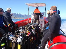
อุปกรณ์
อุปกรณ์มาตรฐาน
จุดดำน้ำส่วนใหญ่ในภูมิภาคนี้ค่อนข้างตื้นและสามารถทำได้บนอากาศด้วยอุปกรณ์ดำน้ำเพื่อการพักผ่อนหย่อนใจทั่วไป ซึ่งรวมถึง:
- ชุดประดาน้ำเต็มรูปแบบที่มีความหนาอย่างน้อย 5 มม. หมวกคลุมศีรษะ รองเท้าบูท และถุงมือ
- กระบอกสูบพร้อมสายรัด ตัวควบคุม และเกจวัดแรงดันใต้น้ำ
- อุปกรณ์ชดเชยการลอยตัว (BCD)
- หน้ากากและสน็อกเกิล
- ครีบ
- ระบบตุ้มน้ำหนักแบบระบายออกได้สอบเทียบอย่างถูกต้องสำหรับอุปกรณ์ที่เหลือ
- คอมพิวเตอร์ดำน้ำหรือเครื่องวัดความลึกและตัวจับเวลาพร้อมตารางการบีบอัดและแผนการดำน้ำ
คุณสามารถเพิ่ม:
- อุปกรณ์เพิ่มเติมใดๆ ที่คุณหรือหน่วยงานที่ออกใบรับรองของคุณอาจพิจารณาว่ามีความจำเป็น เช่น ตัวควบคุมรอง เครื่องเติม BCD แรงดันต่ำ มีด ฯลฯ
- อุปกรณ์ใดๆ ที่คุณพกพาหรือใช้งานตามความชอบส่วนตัว เช่น กล้อง อุปกรณ์ส่งสัญญาณ กระดานชนวนข้อมือ ชุดดรายสูท ทุ่นรอกและทุ่นเครื่องหมายพื้นผิว แหล่งจ่ายแก๊สสำรอง เข็มทิศ ฯลฯ
คำแนะนำ
- หากครีบของคุณมีกระเป๋าที่เท้าเต็ม (ส้นปิด) และรองเท้าชุดประดาน้ำของคุณมีพื้นรองเท้าที่อ่อนนุ่ม คุณอาจต้องสวมรองเท้าเพื่อไปยังจุดเริ่มต้นในการดำน้ำบนชายฝั่ง แนะนำให้ใช้ครีบส้นแบบเปิดและรองเท้าแบบพื้นแข็งสำหรับการดำน้ำบริเวณชายฝั่งส่วนใหญ่ในภูมิภาคนี้ เนื่องจากพื้นมีแนวโน้มจะขรุขระและรองเท้าอาจยังไม่อยู่ที่ที่คุณทิ้งไว้เมื่อคุณกลับจากการดำน้ำ
- ไม่แนะนำให้ใช้ทุ่นระบุตำแหน่งพื้นผิวแบบมาตรฐานในบริเวณที่มีสาหร่ายทะเลโตมาก เนื่องจากจะเกิดการติดขัดบ่อยครั้งและสร้างความรำคาญไม่รู้จบ เครื่องหมายพื้นผิวที่ปรับใช้ได้หรือ "ล่าช้า" นั้นดีกว่าที่ไซต์ดังกล่าวและเป็นสิ่งที่ดีที่จะพกติดตัวไปกับการดำน้ำทางเรือ
- การละทิ้งรายการข้างต้นถือเป็นความเสี่ยงของคุณเอง There are divers who will not wear hoods, or gloves, or boots, or feel that a snorkel or BC is not necessary, or that they can dive in a 3 mm suit. Try this on an easy dive first, where you can get out quickly. It may work for you – there are divers who manage in each of these cases, but you have been warned.
Additional equipment

For each dive site there may be additional or alternative equipment required or recommended, which may improve the dive experience or improve safety at that site. The most commonly recommended items are:
- Compass
- Dry suit
- Light
- Nitrox
- Reel with DSMB
Use of a compass is recommended wherever it may be desirable to swim back to shore below the surface to avoid wind or boat traffic, or to keep below the kelp fronds. It is required for the compass navigation routes.
A dry suit is recommended for most dives on the Atlantic seaboard, or in general if the dive is deeper than about 20 m and the water is colder than 13°C. An appropriate undergarment is required for the dry suit, at this is what provides the insulation. With a suitable combination it is possible to enjoy an hour's dive in comfort at a water temperature of 8°C, when most of the divers in 7-mm wetsuits are cold after 30 minutes. If your face and head are particularly sensitive to cold, a full-face mask will keep your face warm.
Recommendations for a light are for daytime dives, as lights are considered standard equipment on night dives. Backup lights should be carried on night dives from a boat. Underwater flashers may not be well received by the other divers as they are extremely annoying. If you feel you must use one, warn the others and stay away from those divers who do not wish to have a light continually flashing in their peripheral vision and distracting them. A strobe which may be switched on in an emergency is another matter entirely, and is accepted as a valuable safety aid.
The equipment recommendations are for divers who are competent to use those items, and if you are not, you should consider whether your competence is sufficient to dive the site without this equipment.
No recommendations are made regarding equipment for wreck penetration dives and deep dives. If you do not know exactly what equipment is required and have it with you, or are not competent in its use, you should not do the penetration. Depth, wrecks and caves are nature’s tools for culling reckless divers.
Recommendations for gas mixtures are generic. You must choose the appropriate mixture based on your qualifications, competence and the dive plan. Nitrox mixtures are generally recommended to increase dive time without obligatory decompression stops, and Trimix to reduce narcotic effects. Nitrox is available from many of the dive shops, and charter operators will usually provide cylinders filled with the blend of your choice if given sufficient notice. Trimix is more difficult to arrange, as not many filling stations keep Helium in stock, so it may require a bit of shopping around.
Decompression dives should generally only be planned by divers who are familiar with the site, and are competent and properly equipped for the planned dive. Recommendations in this regard are outside the scope of this article, and it will be necessary to discuss any planned decompression dives well in advance with the dive operator, as only a few of them are competent and willing to support planned decompression dives, and those will usually require strong evidence of your competence to do the dive, and advance notice of your dive plan.
Exotic equipment
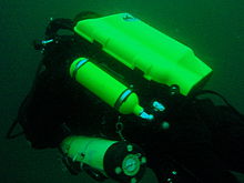

Diving equipment other than open circuit back mounted scuba with half mask and mouth-grip demand valve is considered to be exotic for this section.This would include surface supplied breathing apparatus and full face masks, used as standard equipment by commercial divers, and rebreathers, seldom used by commercial divers, but frequently used by military divers and gaining popularity with Technical recreational divers.
Also considered as exotic equipment is side-mount scuba and diver propulsion vehicles (scooters), as they are not used by many recreational divers.
Generally speaking, any use of surface supplied diving equipment will require special preparation and logistics, which are not available from the listed service providers, but are perfectly legal for use and technical support is available from the suppliers to the commercial diving industry in Cape Town.
Rebreathers are relatively uncommon, but are used by a few local aficionados, and sorb is available over the counter at a few suppliers. There is even one charter boat which regularly runs dives for mainly rebreather divers. Expect to be checked out for skills and certification before being allowed to join these dives, so it would be advisable to make prior arrangements. Technical support is available for a limited range and parts will usually only be available from overseas agencies. Most of the local dive sites do not really justify the expense and relative risk of rebreathers, and they are mostly used by divers who also use them in other places where they are more of an advantage, and by those who just enjoy the technology. They are not available for rental, except in some cases as part of a training package.
Full-face masks will not be a problem, provided you can show your ability to provide buddy support if diving with a partner (some charters will insist that you dive with a buddy). Technical support and parts are available from local agencies for most of the more popular models used for commercial and technical diving, but you may have to wait some time if parts are not in stock. The use of a full-face mask can be a particular advantage when the water is cold, and if you have one and prefer to use it, by all means bring it to Cape Town.
Side mount scuba is relatively uncommon in Cape Town, but there should be no problems if you chose to use it. Do not expect boat crews to know how to help you kit up, but they will probably respond well to explanations. There is a growing number of local side-mount aficionados, including several instructors for side-mount.
Diver propulsion vehicles (scooters) are rare but not unknown. Check with the charter boat whether will be space on board for your unit, and don't expect to find one for rental.
Decompression and bailout sets are not considered exotic, but are not easily available for rental. Bring your own, or ask around. Some of the service providers carry a small range of cylinders suitable for sling mount, but may not have the gas mixture you want in stock. Almost all the local divers that carry decompression or bailout cylinders routinely have their own equipment
จุดดำน้ำ


The dive sites described in these articles include some which are well known favourites and have been dived frequently and by many divers for decades, and also newly described sites, which may only have been dived a few times, and by a few divers. There are also sites which have been known for years, but seldom dived due to their relative inaccessibility, and a few which are basically not particularly interesting, but have been included in the interests of completeness, as the information is available, and occasionally people want to know what they are like. With a few exceptions, the information provided is based on personal observation at the sites by Wikivoyagers. All photos of marine life and features of interest were taken at the listed site.
Geographical information is provided in as much detail as is available. Sites are geolinked, which allows them to be identified on various internet map systems. Positional accuracy is usually good. The maps provided should be usable, to scale, and accurate, but are not guaranteed either to be correct in all details or complete. Clicking on the thumbnail will open a link to a higher resolution image.
Atlantic coast of the Cape Peninsula

Introduction and some tips on diving the Atlantic coast.
This coastline from Table Bay to Cape Point is exposed to the south westerly swells generated by the cold fronts of the Southern Ocean. The continental shelf is narrow in this part of the coast and swells are not greatly influenced by the narrow band of shallow water, so they retain most of their deep-water energy. These swells pound this coast most of the winter, and to a lesser extent in summer, so diving in this region is mostly a summer activity, and the frontal weather patterns far to the south are more important than local weather for swell prediction.
North westerly winds are a feature of the approach of a cold front, and in winter they can be very strong for a few days before swinging to southwesterly as the front passes. These north westerly winter storms were responsible for many shipwrecks in Table Bay and other parts of the west coast, and the associated wind waves can be severe. However the fetch is short and these onshore wind waves do not last long after the storm. They do mess up the visibility though, and this effect lasts for some time after the waves have dissipated.
The south easterly winds are longshore to offshore in this area and tend to knock the swell down a bit. They also cause an offshore displacement of the surface water, which results in deeper water rising to take its place. This upwelling brings colder, initially cleaner water to the inshore areas, and can produce conditions of 20 m visibility and temperatures down to 8°C, though more usually 10° to 12°C. The diving is wonderful if you are sufficiently insulated. Out of the water, however, it is commonly fine and hot, with blazing sunshine high ultraviolet levels and air temperatures in the high 20 and 30° Celsius. This means you will be overheating until you get in the water, hence the comment that summer diving in Cape Town is one easy step from hyperthermia to hypothermia.
There is no escaping the need for a well-fitting, thick (preferably 7 mm), wet suit or a dry suit with an adequate undergarment for these conditions if you intend to stay for more than a few minutes. Carrying a bottle of water with your equipment to wet the outside of your suit before or after putting it on will help keep the temperature down due to evaporative cooling, specially on a windy day. Overheating after leaving the water is seldom a problem. The alternative option of kitting up at the water’s edge requires a shore party to look after your clothes, etc., while you dive, so it has become less common. Do not leave equipment unattended if you wish to see it again.
An upwelling is frequently followed by a plankton bloom, often called a red tide. This will reduce visibility considerably, particularly near the surface. Often the water will be much clearer below the surface layer, though the light levels may be a bit dim and the colour relatively green, or even brownish. The phytoplankton will bloom while the sun shines, so it is much more developed in summer.
The south-easter is an offshore wind at some sites, and besides its influence on temperature and visibility, it also affects the swim back to shore after the dive. The south-easter can appear seemingly out of nowhere on a previously cloudless and windless day, and build up to near gale force in the time you are underwater on a dive, though it is usually predictable, so take note of weather forecasts, and in any case, allow sufficient reserve air to swim back a few metres below the surface. A compass is extremely useful if you do this as it allows you to swim shallower, which is good for air consumption, decompression and warmth. A depth of 3 to 5 m is recommended for a long swim home. The strong south-easter in these cases produces a short, steep wind chop with white-caps which does not penetrate to any significant depth, but the constant slapping of waves and the spray in the air can make snorkelling unpleasant and difficult. There may also be a shallow offshore wind drift (surface current), but this takes some time to develop and gets rapidly weaker with depth and is not usually a problem below about a metre depth inshore. Further offshore the wind induced current can take you several hundred metres during a decompression stop, at a rate of about 0.5 to 1 kph.
When boat diving a deployable surface marker buoy (DSMB) is useful to both facilitate controlled ascent and accurate decompression or safety stop depth, and as a signal to the boat that you are on your way up. In strong wind conditions it will also improve your visibility on the surface, specially if your equipment is all black, so it is worth carrying even if only as a signalling device. Bright yellow has been shown to be best for all round visibility at sea, but orange and red are fairly good too.
Robben Island

These sites are all boat dives. There is no other practical way to get to them, as they are all several kilometres from the mainland across major shipping lanes.The waters around Robben Island were proclaimed a Marine Protected Area in 2019, so a permit is required to dive there. The boat operator will have to have a permit for the restricted area. Details of how this will be done are not yet known.
Local geography:Robben Island is a low, rocky shored island in the mouth of Table Bay. The island and surrounding reefs are rock of the Tygerberg series of the late Precambrian Malmesbury group. These are folded sedimentary rocks, frequently with very steep dip, which often weather to form rather jagged outcrops.
The sites include:
- 1 MV Treasure: S33°40.45' E018°19.95' (approximate)
- Wreck dive. Boat access only. Depth: 30 to 50 m
- On 23 June 2000 the damaged Panamanian registered bulk ore carrier sank off the coast of South Africa approximately 7 nautical miles north of Robben Island.
- The vessel lies upright on a fairly level bottom at about 50 m depth. The superstructure was removed shortly after the sinking by sawing it off at about 30 m depth with a cable towed by tugs as it was a hazard to shipping.
- 2 Robben Island steamer wreck: S33°49.886', E018°21.524' (approximate centre of wreckage)
- Wreck dive. Boat access only. Depth: 30 to 36 m
- Unidentified wreck of a steel steamship about 48 m long in reasonable structural condition.
- 3 MV Afrikaner: S33°50.012' E018°20.686'
- Boat access only. Deep wreck dive. Depth 43 to 50 m
- The 61 m fishing vessel struck Whale Rock in 1993 and sank while being towed away from the rock.
- 4 Whale Rock: S33°50.112' E018°22.858'
- Reef dive. Boat access only. Depth: Mostly less than 10 m
- A large shoal area of rocky reef, usually with a break over the pinnacle, which is the last resting place of a few ships.
- 5 SS Hypatia: S33°50.10’ E018°22.90’ (Turner 1988)
- Wreck and reef dive. Boat access only. Depth: Shallow, maximum probably about 15 m
- British Houston Line steamer of 5 728 tons, built in 1902. Wrecked on Whale Rock in Table Bay on 29 October 1929 in fog while on a voyage from Beira to New York with a cargo of blister copper and chrome ore.
- 6 MV Daeyang Family: S33°50.388' E18°23.133
- Wreck and reef dive. Boat access only. Maximum depth about 15 m
- A large Korean ore carrier which was wrecked on Whale Rock on 1 March 1986 when anchors dragged in heavy weather. The wreckage lies at a depth of about 15:nbsp;m
Table Bay

- 7 MV Winton: S33°52.1514' E18°29.1828 (Engine block)
- Wreck dive. Boat access, though shore access is feasible. Close to surf line. Maximum depth about 6 m.
- Wreck of a small steel freighter on a flat sand bottom.
- 8 MV Gemsbok: S33°53.0' E018°20.5'
- Boat access only. Deep wreck dive. Depth about 57 m on the sand.
- The 50 m 313 tonne buoy tender MV Gemsbok capsized and sank about 4 km from Green Point Lighthouse on 2 Seprember 1975 while transferring an anchor chain of a cargo vessel. The chain snagged and the weight of the chain caused the vessel to capsize and sink within minutes. The wreck lies on its starboard side.
- 9 Highfields: S33°53.13’ E018°25.83’ (Bow)
- Wreck dive. Boat access only. Close to major shipping lane at harbour mouth. Maximum depth 24 m.
- Wreck of a steel barque which sank after a collision in 1902.
- 10 SS Cape Matapan: S33°53.233' E018°24.533' About a kilometer north of Granger Bay harbour
- Wreck and reef dive. Boat access only. Maximum depth 25 m. The wreck is close to the shipping lane and there are no landmarks nearby.
- Wreck of a steel fishing boat which was sunk in a collision in 1960 in heavy fog.
- 11 RMS Athens: S33°53.85’ E018°24.57’
- Wreck and reef dive. Shore or boat access. Maximum depth about 7 m
- Union Company iron steam screw barque of 739 tons, built in 1856. Wrecked between Mouille Point and Green Point on 17 May 1865 during a north-west gale while trying to steam out of Table Bay. The site can be identified by the remains of the engine-block, which is visible above the water.
- 12 SS SA Seafarer: S33°53.80’ E018°23.80’
- Wreck and reef dive. Boat access recommended. Depth: Fairly shallow. Mostly between 5 and 9 m.
- The 8000-ton Safmarine freighter SS South African Seafarer was wrecked in a north westerly gale on 1 July 1966, and lies in front of the Green Point lighthouse.
- 13 Two Oceans Aquarium: S33°54.476’ E018°25.074’
- Shore access only. Confined water. Maximum depth 6 m
- Visitors may dive in the Predator tank, which is a large oval tank, or the Kelp Forest tank, which is roughly square. There are large windows, almost full height on one side, through which you can observe the other visitors watching you if you get bored with the fish.
Sea Point

Local Geography:There is a narrow coastal plain at the base of Signal Hill and Lion’s Head. The contact zone between the intrusive granites of the คาบสมุทร pluton and the sedimentary greywackes and shales of the Tygerberg formation of the Malmesbury series is in this area.The northern sites are on the Tygerberg rocks, which are steeply dipped and form parallel ridges and gullies, while Bantry Bay is on the granite, and has the characteristic corestone topography of rounded boulders and outcrops with sand bottom in deeper areas.
The sites include:
- 14 Three Anchor Bay: S33°54.36’ E018°23.85’
- Reef dive. Shore access. Depth: Shallow
- A small sand bottomed bay with reef to both sides. Easy access.
- 15 Sea Point Ridge Pinnacles: S33°54.905' E018°21.421'
- Reef dive. Boat access. Depth: 17 to 27 m
- An isolated pair of corestone pinnacles on a low granite ridge.
- 16 Bantry Bay: S33°55.56’ E018°22.65’
- Reef dive. Shore or boat access Depth: Less than 10 m
- This little bay is at the southern end of Sea Point, towards Clifton.
Clifton

Clifton Rocks is generally considered a shore dive, but the Paws are quite a distance offshore and are only dived from boats. Parking in Clifton is often a problem, particularly in the kind of weather in which you may wish to go diving. Weekdays will be better and early morning will help. The offshore dives avoid this problem by using boats from Oceana Power Boat Club slipway, which has its own parking problems, though not quite as serious.
Local geography:The suburb of Clifton is built on the rather steep slopes of the base of Lion’s Head above Clifton Bay. There are four beaches in the bay which are famous for white sand, shelter from the south easter and cold water. North Paw is offshore of the headland to the north, and South Paw is offshore from Clifton Rocks, on the south headland. Access to the area by road is from Sea Point to the north and Camps Bay to the south.
The reefs of Clifton are granite corestones of the คาบสมุทร พลูตอน In this area the granite base of the mountain extends to approximately the height of Signal Hill, and is capped by sandstones of the Graafwater and Table Mountain formations. Occasional rounded granite outcrops can be seen on the mountainside, which is mostly deeply weathered granitic saprolite, with some sandstone scree.
The sites include:
- North Lion’s Paw: S33°55.854’ E018°21.849’ (Exposed Rock)
- Reef dive. Boat access only. Depth: 15 to 23 m.
- A spectacular site in good conditions. A popular part of the site is the cave rock, which is slightly offshore from the exposed rocks.
- 17 North Lion’s Paw Northern Pinnacles
- 18 North Lion’s Paw Monty's Pinnacles
- 19 North Lion’s Paw Eastern Pinnacle
- 20 North Lion’s Paw Barry's Pinnacles
- 21 North Lion’s Paw Cave Rock
- 22 North Lion’s Paw Main Reef
- 23 South Lion’s Paw: S33°56.308’ E018°21.890’
- Reef dive. Boat access only. Maximum depth about 20 m.
- An extensive reef of granite corestones marked by the large outcrop which extends above the water.
- 24 Clifton Rocks: S33°56.346’ E018°22.222’
- Reef dive. Shore or boat access. Maximum depth about 14 m.
- A large area of granite corestones, bounded to the north by sand bottom. The reef extends to seaward from the shoreline at the point.
- 25 Cleeve's Tunnel: S33°56.540' E018°21.894'
- Reef dive. Boat access. Maximum depth about 20 m.
- A large corestone pinnacle with a long low tunnel
Camps Bay
Local geography:Camps Bay is in the corner made by Lion’s Head and Table Mountain. Access is over Kloof Nek from the city bowl, and round the coast from Sea Point via Clifton to the north, and from Hout Bay via Oudekraal to the south
The reefs of this area are like those of Clifton.
The sites include:
- 26 Bakoven Rock: S33°57.555’ E018°22.204’
- Reef dive. Shore or boat access. Maximum depth 17 m.
- This site is generally considered a shore dive. Parking is limited so it is most conveniently dived during the working week when there is less competition for space, otherwise get there early.
Oudekraal

This area includes some of the best and most popular shore dive sites on the Atlantic seaboard. Most can also be dived from a boat, and this is of particular importance to divers with restricted mobility on shore, as there is generally a rugged bit of coast to negotiate and in some cases a long climb. There is also a moderate to long swim at some of the sites, and at some states of the tide, heavy kelp inshore.
Local geography:The coastline at the base of the Twelve Apostles range just south of Table Mountain is steep, and south of Camps Bay, virtually undeveloped. Fortunately for divers, the coastal road is not far above sea level in the north of this area, and though there are not many off-road parking areas, the road is wide enough to park along the side.
This is an area of pale grey คาบสมุทร Granite corestone outcrops and boulders with some Table Mountain Sandstone boulders which have rolled down the mountainside to the water’s edge. The mountainside below the sandstone cliffs is deeply weathered granite saprolite with occasional corestone outcrops. The cuttings at the roadside display the granular yellow-brown saprolite with a thin soil covering. The underwater topography is almost entirely corestones exposed by erosion, surrounded by samd, and is a continuation of the granite boulders and outcrops at the water’s edge.

North Oudekraal
The sites include:
- 27 Dreadlocks Reef: S33°58'22.05" S18°21'42.59"
- Reef dive. Boat access. Depth: 1.5 to 20 m.
- A relatively new site. First survey 30th January 2010. This granite ridge peaks about 1.5m from the surface at low tide, but the tip is small and seldom breaks. Bottom on low granite at about 20m. Colourful and diverse invertebrate cover, and notable for the relatively large colonies of Dreadlock hydroids.
- 28 Geldkis Blinder: S33°58.67’ E018°21.62’
- Reef dive. Boat or shore access. Maximum depth about 20 m.
- A relatively infrequently dived site. The highest rock on the reef is a blinder beyond Geldkis rock which occasionally breaks the surface at low tide. Huge boulders and outcrops, and a few swimthroughs.
- 29 Strawberry Rocks: S33°58.725’ E018°21.658’ (approximate)
- Reef dive. Shore or boat access. Maximum depth about 15 m.
- The two smaller rocks to the north of Geldkis rock. Several small caverns and swimthroughs.
- 30 Geldkis: S33°58.73’ E018°21.61’
- Reef dive. Shore or boat access. Maximum depth about 15 m.
- A large group of rocks with lots of overhangs, swimthroughs and chimneys. The Dutch East Indiaman Het huys te Craijestein was wrecked on the rocks in the bay at Oudekraal on 27 May 1698 in thick mist. Three chests of treasure disappeared and the name "Geldkis" (money-chest) appears on maps of the area and is now applied to the offshore rocks.
- 31 Boardroom: S33°58.761’ E018°21.151’
- Reef dive. Boat access, though possible from shore. Maximum depth about 21 m near the pinnacle, but deeper water nearby. about 10 m on top.
- A very large boulder with a large swimthrough cave and a large overhang in an area of high profile boulder reef.
- 32 Het Huis te Kraaiestein: S33°58.85’ E018°21.65’
- Wreck and reef dive. Shore access. Maximum depth 10 m.
- Remnants of the Dutch East Indiaman Het Huis te Kraaiestein of 1,154 tons, which was wrecked in the bay at Oudekraal on 27 May 1698 in thick mist while trying to find the way into Table Bay. Some cannon, anchors and a few baulks of timber are all that are usually visible above the sand.
- 33 Mushroom Pinnacle: S33°58.781’ E018°21.521’
- Reef dive. Shore or boat access. Maximum depth 17 m.
- A submerged granite tor (stacked group of large corestones) between Geldkis and Justin’s Caves. The pinnacle is surrounded by lower outcrops separated by sandy gullies.
- 34 Sandy Cove: S33°58.90’ E018°21.65’
- Reef dive. Confined waters. Shore access. Maximum depth 4 m
- A shallow sheltered cove at Oudekraal, suitable for open water training exercises, refresher courses and testing equipment when you don’t need depth. Entry area for several other sites.
- 35 Justin’s Caves: S33°58.85’ E018°21.50’
- Reef dive. Shore or boat access. Maximum depth about 13 m.
- A group of big granite corestone outcrops and boulders with several swimthroughs, overhangs, caves and deep narrow gaps between the rocks. Spectacular in good visibility, colourful reef life.

Central Oudekraal
The sites include:
- 36 Antipolis: S33°59.06’ E018°21.37’ (Bow section)
- Wreck and reef dive. Shore or boat access. Maximum depth about 10 m.
- The tankers "Romelia" and "Antipolis" were under tow on 28 July 1977 during a north westerly gale when the tow cable to the "Antipolis" snagged on the sea bed. In the ensuing confusion the cables broke and the two ships were driven aground by the wind. The "Antipolis" ran aground at Oudekraal and was later cut down to water level.
- 37 Klein Pannekoek: S33°58.91’ E018°21.09’
- Reef dive. Boat or shore access. Maximum depth about 15 m.
- A group of large fairly low and flat rocks visible offshore to the west of the "Antipolis" and north of Coral Gardens.

South Oudekraal
The sites include:
- 38 Groot Pannekoek: S33°59.13’ E018°20.75’
- Reef dive. Boat or shore access. Maximum depth about 15 m
- A large flattish outcrop of granite, which extends a short way above the sea level at all tides. Some overhangs, crevices and small caves.
- Coral Gardens (Oudekraal): S33°59.270' E018°20.782' (The pinnacles)
- Reef dive. Shore or boat access. Maximum depth 17 m
- A spectacular dive in good conditions. Huge granite boulders in groups with open patches between them. There are overhangs, small caverns, a few swimthroughs, and many deep gaps and crevices. Extensively covered in colourful reef life. Possibly the best shore dive on the Atlantic side of the Cape Peninsula on a good day.
- 39 Coral Gardens
- 40 Coral Gardens Offshore Pinnacle
Llandudno

These sites can be accessed from the shore or by boat. Parking is limited, but the area is reasonably secure. Some walking is required, but no serious climbing as the parking is near the sea level.
Local geography:The small residential suburb of Llandudno is built on the moderately steep slopes of the Cape Peninsula below the peak of Klein-Leeukop, where the coast road (M6 – Victoria Drive) from Camps Bay crosses over the neck to Hout Bay. There is only one way into Llandudno by road, which is from the M6 near the top of the pass.This is an area of granite corestone reefs with sand bottom.
The sites include:
- 41 13th Apostle: S33°59.486' E18°19.922'
- Reef dive. Boat access. Depth: 10 to 24 m.
- A large granite pinnacle on an area of low granite reef with occasional sand patches.
- 42 Llandudno Reef: S34°00.037' E18°19.897'
- Reef dive. Boat access. Depth: 10 to about 30 m, on sand
- An unsurveyed granite reef, with several pinnacles, outcrops and gullies.
- 43 Logies Bay: S34°00.25’ E018°20.53’
- Reef dive. Shore access. Maximum depth probably about 10 m.
- A small rocky cove to the north of Llandudno beach.
- 44 MV Romelia: S34°00.700’ E018°19.860’ approximately
- Wreck and reef dive. Shore or boat access. Maximum depth about 24 m.
- The tankers Romelia และ Antipolis were under tow on 28 July 1977 during a north westerly gale when the tow cable to the Antipolis snagged on the sea bed. In the ensuing confusion the cables broke and the two ships were driven aground by the wind. Romelia ran aground at Sunset Rocks, Llandudno, where its back was broken by the heavy surf and the ship split in two. Later the bow section sank, leaving the stern mostly above sea level on the rocks. Over the years the stern section has also broken up and is no longer visible above the water.
Oude Schip headland
Local geography:Oude Schip headland lies at the foot of the Karbonkelberg between Sandy Bay to the north and Leeugat to the south, It is a low rocky headland of Peninsula granite, with several reef dives and one known wreck. It is a fairly exposed section of coast but protected from the south easterly winds by the mountain. The sites are only accessible by boat as there is no road access to this part of the shore, and most are too far offshore to safely swim.
This is an area of granite bedrock of the คาบสมุทร pluton, The reefs are exposed corestone outcrops and boulders, with sand patches in the deeper areas
The sites include:
- 45 Steps: S34°01.330’ E018°18.600’
- Reef dive. Boat access only. Maximum depth about 20 m.
- An area of high granite reef with deep gullies. Not actually in Leeugat, but just north of Oude Schip headland.
- 46 MV Harvest Capella: S34°01.600’ E018°18.750’
- Wreck dive. Boat access only. Maximum depth about 15 m.
- An area of mostly flattish granite reef with a few ridges and some wreckage of a steel motor fishing vessel, some of which has washed up onto the point and is visible from a distance. Not actually in Leeugat, but on the north shore of Oude Schip headland.

The Blue Flash Reefs
- 47 Rachel's Reef: S34°01.431' E018°18.151'
- Reef dive. Boat access only. Depth between about 3 and 21 m.
- Rachel's Reef is a compact granite pinnacle with surrounding high profile reef.
- 48 Humpback Ridge: S34°01.548' E018°18.142'
- Reef dive. Boat access only. Depth between about 4 and 21 m.
- A fairly massive granite pinnacle in the middle of a more extensive north-south ridge rising to about 12 m. Humpback whales have been seen near these reefs on several occasions.
- 49 Wilhelm's Wall: S34°01.502’ E018°17.931’
- Reef dive. Boat access only. Depth between about 12 and 31 m.
- A granite ridge somewhat more than 50 m long with sheer faces to the north and south, a flattish bottomed gully to the south, and another, more broken ridge south of the gully. Colourful sessile invertebrates on the sides and seaweeds on top.
The Middelmas reefs:
- Hakka Reef (Middelmas): S34°01.747’ E018°18.328’
- Reef dive. Boat access only. Maximum depth about 21 m.
- 50 Die Middelmas is a rock that projects several metres above the water at all tides, to the west of the Oude Schip peninsula.
- 51 Hakka Reef Southeast pinnacles is off this rock.
- 52 Hakka Reef Sven's Caves pinnacles is nearby at a set of pinnacles near a sand patch.
- 53 Twin Towers: S34°01.920’ E018°18.330’
- Reef dive. Boat access only. Depth about 20 m at the tops of the pinnacles to 34 m on the sand.
- A small but tall double-peaked granite pinnacle on a narrow base reef and surrounded by sand.
Leeugat (Maori Bay)

.jpg/220px-Gelderland_(1).jpg)
Although several of the sites are quite close inshore, this area is in practice only accessible by boat, as the distance to the nearest parking is too far to carry dive gear (about 3 km as the crow flies, more on foot).
Local geography:Leeugat, also known to divers as Maori Bay, lies at the foot of the Karbonkelberg, between the northern headland of Oude Schip, and Duikerpunt to the south. It is a small bay, but fairly deep close inshore, which in combination with the partial barrier afforded by the reefs at the headlands, has provided the wrecks in Leeugat bay with better protection from wave action than those on more exposed parts of the coastline. This means that not only have they lasted well for their ages, but conditions are suitable for diving more often than for many other wrecks on the Atlantic seaboard of the Cape Peninsula.
This is an area of granite bedrock of the คาบสมุทร pluton, The reefs are exposed corestone outcrops and boulders, with sand patches in the deeper areas
The sites include:
- 54 MV Keryavor and the Jo May: S34°02.037’ E018°18.636’
- Wreck and reef dive. Boat access only. Depth: Not available, probably between 25 and 30 m.
- These two wrecks lie next to each other approximately between the Maori and the Gelderland. Jo May sank first and not much of her wooden structure remains. Ker Yar Vor was a steel lobster fishing vessel and several chunks of hull structure and twisted sections of plating remain.
- 55 SS Maori: S34°02.062’ E018°18.793’ (Machinery)
- Wreck and reef dive. Boat access only. Depth: 6 to 21 m
- The SS Maori was a typical British steam cargo vessel of the early 1890s. The ship was wrecked in the bay between Oude Schip and Duikerpunt on 5 August 1909 in thick fog and drizzle while on a voyage from London to New Zealand.
- 56 SAS Gelderland: S34°02.070’ E018°18.180’
- Wreck and reef dive. Boat access only. Depth: 30 to 35 m
- The Ford class Seaward Defense Boat SAS Gelderland was scuttled on 21s ecember 1988, north west of Duiker Point, as demolition trials.
- The vessel was about 40 m long but the main part of the wreckage is now only about 20 m long as the bow and stern sections were blown right off.
- Plan B pinnacle is just to the south of the southernmost wreckage.
- 57 SS Oakburn / MV Bos 400: S34°02.216’ E018°18.573’
- Wreck and reef dive. Boat access only. Depth: Maximum 22 m
- The "Oakburn", a British cargo steamer of 3865 tons, was wrecked on the north side of Duikerpunt in fog on 21 May 1906, on a voyage from New York to Sydney. The Oakburn has pretty much fallen apart, and on 27 June 1994, the French pipe-laying crane barge Bos 400, broke its towline and stranded virtually on top of the older wreck. The Bos has started to break up, and two large sections have collapsed into the sea, though the main crane section is still firmly stuck on top of the rocks.
Outer Hout Bay


This area includes the dive sites between Duiker Point and Duiker Island and the extensive reefs to the south as far as Vulcan Rock and Tafelberg Reef. All of these are only accessible by boat. There are a number of sites being explored in this area: the reefs between Kanobi’s wall and Stonehenge, and a wreck of a lifeboat which was used to salvage materials from the Boss 400 and which lies between Stonehenge and Duiker Island are among these. There are several unexplored pinnacles in the region identified on the SAN charts as bakleiplaas, where the sea is often very lumpy due to the influence of the underwater topography on the swell.
Local geography:The suburb of Hout Bay lies in the valley between the Constantiaberg to the east and the peninsula formed by Karbonkelberg and its lesser peaks to the west. One of these peaks, the Sentinel, gives its name to a dive site at its foot. At the mouth of the valley is the business area of Hout Bay, with its small commercial fishing harbour and marina, and a public slipway used by dive charters and private dive boats for access to most of the southern peninsula dive sites on the Atlantic coast. The slipway is in good condition, wide and accessible, and has a large parking area, which on occasions can be crowded due to heavy use by commercial fishing skiboats.
The bedrock of this area is granite of the คาบสมุทร pluton, and most of the sites are on corestone reefs of this rock.
The sites include:
Duiker Point sites:
- 58 Die Perd: S34°02.282’ E18°18.324’
- Reef dive. Boat access only. Depth: Not available, maximum probably about 20 m
- This rock off Duiker Point extends above the water and is surrounded by rugged reefs of high outcrops and deep gullies.
- 59 Kanobi’s Wall: S34°02.365’ E018°18.138’
- Reef dive. Boat access only. Maximum depth about 25 m.
- This blinder off Duiker Point is a good site with rugged topography, good biodiversity and large depth variation. Huge boulders are stacked, with tunnels, overhangs and caves of various sizes, and lots of vertical walls, some probably 10 m or more in height.
- 60 SURG Pinnacles: S34°02.375' E018°18.015'
- Reef dive. Boat access only. Depth 9 to over 30 m.
- A group of steep granite corestone pinnacles, probably mostly huge boulders, with walls, overhangs and a swimthrough. Deep narrow cracks divide the pinnacles. Spectacular topography, covered with lots of sea urchins and vast numbers of hairy brittlestars, a moderate variety of sponges, noble corals, gorgonians, and patches of cauliflower soft coral. Red bait and Laminaria on the tops of the pinnacles. Surge can be strong when a long swell is running.
- Star Wall: S34°02.466' E18°18.087' (pinnacle)
- Reef dive. Boat access only. Depth: 6 to 32 m.
- This site has the tallest and longest wall known in the Cape Town area and is a dive site well worth visiting. A massive and continuous granite wall of about 25m almost vertical height, extending for a length of 100 m on the south face and 50 m on the south-east face. Very diverse and colourful invertebrate cover on the wall face. The sites are:
- 61 Star Wall
- 62 Star Wall - M&M Cave
- 63 Star Wall - Lollipop Pinnacle
- 64 Sunfish Pinnacle: S34°02.475' E18°18.290' (pinnacle)
- Reef dive. Boat access only. Depth: 7 to 26 m.
- A fairly large pinnacle on a rocky bottom on the way to Duiker Point from Hout Bay harbour, which has been picked up quite frequently on the echo sounders of dive boats passing over it. It has now been dived, and to some extent mapped. The site is quite pretty and should make a pleasant alternative site. Topography is rugged, with high vertical walls on two sides of the pinnacle.
Stonehenge sites:
- 65 Canyon: S34°02.595’ E018°18.073’
- Reef dive. Boat access only. Maximum depth about 35 m.
- The area is named for a gully between rows of pinnacles. Big boulders and rock outcrops cover an extensive area.
- Stonehenge: S34°02.838’ E018°18.316’
- Reef dive. Boat access only. Maximum depth about 22 m.
- The area is named for a group of tall rocks which break the surface. Big boulders and rock outcrops cover an extensive area. High profile in the deeper areas, with swimthroughs, holes and overhangs. Heavy kelp in some areas. Included in this area, Stonehenge Blinder, a pinnacle that approaches the surface and breaks in a large swell or at low tide.
- 66 Stonehenge Dusky Pinnacles - Coral Pinnacle
- 67 Stonehenge North
- 68 A-340 Pinnacle
- 69 Stonehenge Central
- 70 Stonehenge South
- 71 Stonehenge Blinder
- 72 Stonehenge Wreck
Seal Island sites:
- 73 Seal Island (Duiker island): S34°03.458’ E018°19.562’
- Reef dive. Boat access only. ความลึก: ตื้น ส่วนใหญ่น้อยกว่า 6 เมตร
- เกาะหินขนาดเล็กที่ทำเครื่องหมายไว้บนแผนที่และแผนภูมิเมื่อ Duikereiland กลายเป็นที่รู้จักในนาม Seal Island เนื่องจากมีถิ่นที่อยู่ของแมวน้ำซึ่งได้กลายเป็นสถานที่ท่องเที่ยว ไม่ควรสับสนกับ เกาะแมวน้ำ ในอ่าวเท็จ
ไซต์วัลแคนร็อค:

- 74 Di's Cracks: S34°03.855’ E018°18.400’ – จุดสุดยอดขนาดใหญ่ 14 เมตร - ก้อนหินที่อยู่ด้านบนของแนวปะการัง ประมาณ 300 ม. ทางตะวันตกเฉียงเหนือ (328° แม่เหล็ก) ของวัลแคนร็อค
- ดำน้ำดูปะการัง. เข้าได้ทางเรือเท่านั้น ความลึก: 10 ถึง 30 ม.
- การดำน้ำที่งดงามหากทัศนวิสัยดี ผนังและส่วนที่ยื่นออกมาจำนวนมาก ร่องน้ำ และรอยแตกที่ลึกและกว้าง ฝาครอบสัตว์ไม่มีกระดูกสันหลังที่อุดมไปด้วย ไซต์ที่ดีสำหรับการถ่ายภาพทิวทัศน์มุมกว้างที่น่าทึ่ง
- 75 วัลแคน ร็อค: S34°03.967’ E018°18.582’
- ดำน้ำดูปะการัง. เข้าได้ทางเรือเท่านั้น ความลึกสูงสุดกว่า 25 เมตร ใกล้โขดหิน
- หินวัลแคนเป็นจุดที่สูงที่สุดของแนวปะการังหินแกรนิตขนาดใหญ่และแตกตัวออกจากผิวน้ำในบางสภาวะของกระแสน้ำ มันต่ำและแบนอยู่ด้านบน การดำน้ำที่งดงามหากทัศนวิสัยดี
ไซต์แนวปะการังทาเฟลเบิร์ก:
- 76 แนวปะการังทาเฟลเบิร์ก: S34°04.22’ E018°18.93’
- ดำน้ำดูปะการัง. เข้าได้ทางเรือเท่านั้น ความลึก: 8 ถึง 30 ม.
- มีพื้นที่กว้างขวางเป็นหินแกรนิตขรุขระ นูนสูงและพื้นทรายไปทางทิศตะวันตกประมาณ 29 เมตร ร่องลึกและร่องน้ำ ยื่นไม่มากนัก แต่มีใบหน้าแนวตั้งจำนวนมาก ภูมิประเทศที่ขรุขระและงดงามมากในทัศนวิสัยที่ดี
- 77 แนวปะการังไคลน์ทาเฟลเบิร์ก (ชามสลัด ซากเรือยอชท์): S34°04.442' E018°19.191'
- ดำน้ำดูปะการัง. เข้าได้ทางเรือเท่านั้น ความลึก: 14 ถึง 36 ม.
- หินแกรนิตขนาดใหญ่ที่มีโขดหินขนาดใหญ่ พื้นทรายในบริเวณที่ลึกกว่า ภูมิประเทศที่ขรุขระและงดงาม ซากปรักหักพังของเรือยอทช์ GRP อยู่ในร่องที่ด้านข้างของจุดสุดยอด เป็นไปได้ที่จะดำน้ำลึก 40 ถึง 45 ม. โดยเริ่มจากทรายไปทางทิศตะวันออกของแนวปะการัง และว่ายน้ำขึ้นไปตามแนวปะการังที่มุ่งหน้าไปทางทิศตะวันตกเฉียงเหนือ แต่มีแนวโน้มว่าจะต้องคลายการบีบอัดหากคุณไปจนสุดทาง จุดสุดยอดตื้น
- Tafelberg Deep:
- ดำน้ำดูปะการัง. เข้าได้ทางเรือเท่านั้น ความลึกสูงสุดประมาณ 40 เมตรบนพื้นทราย
- หินแกรนิตที่มีรายละเอียดต่ำถึงปานกลาง ลาดขึ้นไปทาง Tafelberg Deep Pinnacle ทางใต้ของจุดสุดยอดที่แนวปะการังไคลน์ทาเฟลเบิร์ก เป็นไปได้ที่จะดำน้ำลึก 50 ม. และแหวกว่ายไปตามแนวปะการัง แต่จำเป็นต้องมีการคลายการบีบอัด
- 78 Tafelberg Deep
- 79 Tafelberg Deep Pinnacle
เฮาท์เบย์


บริเวณนี้รวมถึงพื้นที่ระหว่าง Sentinel และ Chapmans Peak ส่วนใหญ่เป็นการดำน้ำทางเรือ ข้อยกเว้นประการหนึ่งคือ Sentinel สามารถเข้าถึงได้โดยทางบกโดยไม่ยากนัก แต่มีปัญหาด้านความปลอดภัย
Sentinel เป็นพื้นที่ทั่วไปของแนวชายฝั่งหินแกรนิต โดยมีโขดหินจำนวนมากตามแนวชายฝั่งและแนวปะการังแกนหลักที่มีรูปแบบโค้งมนตามปกติ ซากปรักหักพังของ Aster และ Katsu Maru อยู่บนพื้นทรายเรียบ และไซต์ที่ Die Josie อยู่บน หินแกรนิตที่ไม่ผุกร่อนที่ฐานหน้าผาของยอดเขาแชปแมนตอนล่าง
เว็บไซต์รวมถึง:
- 80 Sentinel:
- ดำน้ำดูปะการัง. การเข้าถึงฝั่งหรือทางเรือ ความลึก: ส่วนใหญ่น้อยกว่า 10 ม.
- นี่คือสถานที่บนชายฝั่งมหาสมุทรแอตแลนติกซึ่งมีความลึก 30 เมตรอยู่ใกล้ชายฝั่งที่สุด
- ยามรักษาการณ์บางคนถือว่าเป็นพื้นที่ใต้หน้าผาแนวตั้ง และเป็นพื้นที่ราบที่มีสาหร่ายทะเลและแมงกะพรุนกล่องจำนวนมาก และหินก้อนใหญ่บางก้อน
- The Pinnacles คือกลุ่มหินที่อยู่ใกล้ชายฝั่งใกล้กับท่าเรือ Hout Bay ใกล้กับโรงบำบัดน้ำเสีย
- 81 MV Aster: S34°03.891’ E018°20.955’
- ดำน้ำซาก. เข้าได้ทางเรือเท่านั้น ความลึกสูงสุด 28 ม.
- เรือประมงขนาด 340 ตัน ยาว 27 ม. "Aster" เป็นเรือประมงกุ้งล็อบสเตอร์ที่จดทะเบียนในแอฟริกาใต้ ซึ่งเตรียมให้เป็นแนวปะการังเทียมที่เป็นมิตรกับนักประดาน้ำด้วยการทำความสะอาดและตัดช่องเปิดเข้าไปในโครงสร้าง และแล่นไปในอ่าว Hout ใกล้กับซากปรักหักพังของ "MV Katzu Maru" เมื่อวันที่ 9 สิงหาคม พ.ศ. 2540 ถูกใช้เป็นสถานที่ฝึกอบรมการเจาะซากเรืออับปาง เรือตั้งตรงที่ด้านล่างและเริ่มแตก
- 82 MV คัตสึ มารุ: S34°03.910’ E018°20.942’ (กลางซากเรือ)
- ดำน้ำซาก. เข้าได้ทางเรือเท่านั้น ความลึกสูงสุดประมาณ 30 ม.
- เรือลากอวนของญี่ปุ่น "คัตสึ มารุ #25" ชนวัตถุที่ไม่สามารถระบุตัวตนได้ในทะเล และถูกซ่อนไว้ที่ฝั่งท่าเรือ ขณะลากจูงเรือไปยังอ่าวเฮาท์ เรือถูกน้ำท่วมและจมลงในอ่าวเมื่อวันที่ 7 สิงหาคม พ.ศ. 2521 ซากเรืออับปางอยู่ทางด้านขวาของพื้นทราย
- 83 ตายโจซี่: S34° 04.497’ E018° 21.256’
- ดำน้ำดูปะการัง. เข้าได้ทางเรือเท่านั้น ความลึก: 7 ถึง 17 ม.
- แนวปะการังตื้นด้านล่าง Chapman's Peak ซึ่งอยู่ใกล้กับท่าเรือ Hout Bay และเหมาะสำหรับการดำน้ำตอนกลางคืน หนึ่งในไม่กี่แห่งที่หินแกรนิตไม่โค้งมนจากสภาพอากาศ ดังที่เห็นได้จากหน้าผาเหนือพื้นที่
คาบสมุทรแอตแลนติกใต้

บริเวณนี้รวมถึงชายฝั่งคาบสมุทรทั้งหมดทางตอนใต้ของ Noordhoek มักจะไม่ดำน้ำเพื่อจุดประสงค์ในการพักผ่อนหย่อนใจ เนื่องจากอยู่ไกลจากจุดปล่อยที่ดีและไม่ค่อยมีใครรู้จักแหล่งดำน้ำที่ดีมากนัก มีซากเรือหลายแห่งในบริเวณนี้ โดยเฉพาะที่ Albatross Rocks/Olifantsbospunt มีซากเพียงไม่กี่แห่งเท่านั้นที่ได้รับการระบุในเชิงบวก
เว็บไซต์ได้แก่
- 84 SS แคลนมอนโร: S34°08.817' E18°18.949'
- ดำน้ำซากและแนวปะการัง เข้าได้ทางเรือเท่านั้น ความลึก: 4 ถึง 8 ม.
- ซากปรักหักพังทางเหนือเล็กน้อยของประภาคาร Slangkop ที่ Kommetjie ไม่ค่อยได้ดำน้ำ แนวปะการังหินทรายแบนตื้น มีซากเรือหุ้มด้วยสาหร่ายคอรอลไลน์
- SS Thomas T. Tucker:
- ดำน้ำซากและแนวปะการัง เข้าได้ทางเรือเท่านั้น ความลึก: ตื้น
- เรือลำนี้อับปางอยู่บนโขดหิน และบางส่วนของซากปรักหักพังสามารถมองเห็นได้บนฝั่ง ซากปรักหักพังส่วนใหญ่อยู่ในน้ำค่อนข้างตื้น
- 85 ดาราแห่งแอฟริกา:
- ดำน้ำซากและแนวปะการัง เข้าได้ทางเรือเท่านั้น ความลึก: สูงสุดประมาณ 27 ม.
- 86 SS Bia: ส่วนโค้ง: S34°16.140' E018°22.812' ส่วนหลัก: S34°16.217' E018°22.638'
- ดำน้ำซากและแนวปะการัง เข้าได้ทางเรือเท่านั้น ความลึก: 3 ถึง 8 ม.
- 87 SS Umhlali: S34°16.435' E18°22.487'
- ดำน้ำซากและแนวปะการัง เข้าได้ทางเรือเท่านั้น ความลึก: 5 ถึง 8 ม.
- 88 อัลบาทรอสร็อค: S34°16.495' E18°22.197'
- ดำน้ำดูปะการัง. เข้าได้ทางเรือเท่านั้น ความลึก: น่าจะน้อยกว่า 15 เมตรใกล้หิน
- แนวปะการังตะวันตกเฉียงใต้:
- ดำน้ำดูปะการัง. เข้าได้ทางเรือเท่านั้น ความลึก: ไม่แน่นอน
- พื้นที่กว้างใหญ่ของแนวปะการังตื้นและสาหร่ายเคลป์ทางทิศตะวันตกของปลายคาบสมุทร เป็นที่หลอกหลอนของนักตกปลาสเปียร์ฟิชเชอร์และนักจับกั้งและยังมิได้สำรวจด้วยการดำน้ำลึก
ชายฝั่งอ่าวเท็จของแหลมคาบสมุทร


บทนำและเคล็ดลับบางประการเกี่ยวกับการดำน้ำบนชายฝั่ง False Bay ของ Cape Peninsula (ฝั่ง Simon's Town)
ฝั่งตะวันตกของฟอลส์เบย์มีที่กำบังจากตะวันตกในฤดูหนาว ต่างจากส่วนอื่นๆ ในภูมิภาค แต่ในทางกลับกัน ทางฝั่งตะวันออกเฉียงใต้ก็มุ่งหน้าไปทางทิศตะวันออกเฉียงใต้ ด้วยเหตุนี้ ภูมิภาคนี้จึงมักจะดำน้ำตื้นในฤดูหนาว ซึ่งทางตะวันออกเฉียงใต้แทบจะไม่พัดมาเป็นเวลานานหรือมีลมพัดแรงมาก
พายุหน้าหนาวที่พัดปกคลุมมหาสมุทรทางใต้ทำให้เกิดคลื่นที่พัดช้าจากไหล่ทวีปและหักเหและกระจายไปทั่วคาบสมุทรเคป กระจายไปทั่วบริเวณแนวชายฝั่งเป็นส่วนใหญ่ และสูญเสียพลังงานไปมากเมื่อถึงเวลาที่เคลื่อนตัวเข้าหา ฝั่ง รูปทรงที่ไม่สม่ำเสมอของชายฝั่งที่นี่ยังปกป้องพื้นที่บางส่วนได้มากกว่าพื้นที่อื่นๆ โดยทั่วไปแล้ว ส่วนต่างๆ ของชายฝั่งที่ไหลไปทางทิศตะวันตกเฉียงเหนือไปตะวันออกเฉียงใต้จะได้รับการคุ้มครองจากคลื่นลมตะวันตกเฉียงใต้ได้ดีกว่าส่วนเหนือจรดใต้ ดังนั้นการเลือกแหล่งดำน้ำจะขึ้นอยู่กับรูปแบบสภาพอากาศล่าสุด
ในช่วงฤดูร้อนที่ตะวันออกเฉียงใต้พัดบ่อยขึ้น นานขึ้น และหนักขึ้น โดยทั่วไปบริเวณนี้จะไม่สามารถดำน้ำได้ และทัศนวิสัยโดยทั่วไปจะแย่กว่าในฤดูหนาว แม้ว่าจะมีสภาพอากาศที่เหมาะสมก็ตาม
อุณหภูมิของน้ำในช่วงฤดูหนาวในบริเวณนี้โดยทั่วไปจะอบอุ่นกว่าชายฝั่งมหาสมุทรแอตแลนติกในฤดูร้อน ซึ่งเป็นการชดเชยสำหรับช่วงเวลากลางวันที่สั้นลง และมักจะเป็นสภาพอากาศหนาวเย็นและมีฝนตก
อุณหภูมิของน้ำอาจแตกต่างกันไปตามความลึก โดยปกติจะมีเทอร์โมไคลน์ในฤดูร้อน และทัศนวิสัยอาจเปลี่ยนแปลงอย่างมีนัยสำคัญด้านล่างเทอร์โมไคลน์ พื้นผิวสามารถมีอุณหภูมิ 18 หรือ 19°C โดยที่ 10 หรือ 11°C ที่ด้านล่าง แต่ความแตกต่างน่าจะอยู่ที่ 5°C หรือน้อยกว่า สภาวะที่ความลึกไม่สามารถคาดเดาได้ง่าย และอาจจะดีกว่าหรือแย่กว่าบริเวณใกล้ผิวน้ำ อาจมีแพลงก์ตอนบานสะพรั่งในชั้นผิวน้ำ และการมองเห็นที่ดีขึ้นอย่างกะทันหันจาก 3 เมตรหรือน้อยกว่าเป็น 10 เมตรในน้ำด้านล่างที่เย็นจัด ความลึกของเทอร์โมไคลน์ยังไม่สามารถคาดเดาได้มากนัก แต่ทราบกันดีอยู่แล้วว่าอยู่ระหว่าง 12 ถึง 20 เมตรในช่วงปลายฤดูร้อน
ในฤดูหนาว น้ำอาจมีอุณหภูมิเท่ากันจากบนลงล่าง และเนื่องจากมีแสงแดดน้อยกว่าที่จะให้พลังงานแก่แพลงก์ตอนพืชได้ ทัศนวิสัยและแสงสว่างจากธรรมชาติจึงดีขึ้นแม้ว่าจะมีแสงน้อย
ระหว่างหน้าหนาวกับหน้าฝน มักจะมีวันที่ลมพัดน้อยหรือไม่มีเลย และมีแสงแดดอ่อนถึงอบอุ่น เมื่อน้ำทะเลใสและใสและการดำน้ำที่ยอดเยี่ยม และไซต์จำนวนมากทำให้ยากต่อการตัดสินใจว่าจะไปที่ไหน มีทางเลือกมากมาย มันเป็นชีวิตที่ยากลำบากในตอนท้ายของแอฟริกา แต่มีใครบางคนต้องทำ
อุณหภูมิของน้ำในฤดูหนาวมักจะอยู่ระหว่าง 13°C ถึง 17°C แม้ว่าจะทราบกันดีอยู่แล้วว่าอุณหภูมิจะลดลงถึง 11°C ก็ตาม ดังนั้นจึงจำเป็นต้องมีชุดสูทที่ดี ในฤดูร้อน อุณหภูมิอาจสูงกว่า 20°C แต่มีแนวโน้มว่าจะอยู่ที่ประมาณ 17°C ถึง 19°C
การดำน้ำชายฝั่งส่วนใหญ่ค่อนข้างตื้น โดยเรียงลำดับจากความลึกสูงสุด 8 ม. ถึง 15 ม. แม้ว่าจะเป็นไปได้ที่จะดำน้ำที่ฝั่ง 30 ม. หากคุณไม่รังเกียจที่จะว่ายน้ำเป็นระยะทาง 700 ม. น้ำตื้นทำให้ชุดดรายสูทได้เปรียบน้อยลง แต่การออกจากชุดประดาน้ำท่ามกลางลมและฝนในตอนกลางคืนจะดันชุดดรายขึ้นอีกครั้งเพื่อเป็นทางเลือกที่ดี เป็นเรื่องดีที่มีทางเลือก และนักดำน้ำในท้องถิ่นจำนวนมากจะแลกเปลี่ยนชุดเปียกและชุดแห้งโดยขึ้นอยู่กับแผนการดำน้ำที่วางแผนไว้
มุยเซนแบร์กไปยัง Kalk Bay

ไซต์เหล่านี้เป็นไซต์ที่อยู่เหนือสุดของฝั่งตะวันตกของฟอลส์เบย์ พวกมันตื้นและถูกลมและคลื่นของตะวันออกเฉียงใต้ ดังนั้นจึงถือว่าเป็นการดำน้ำในฤดูหนาว
ภูมิศาสตร์ท้องถิ่น:มีผืนดินแคบๆ ระหว่างไหล่เขากับทะเล ซึ่งถูกครอบครองโดยชานเมืองเซนต์เจมส์และอ่าวคาล์ค และทางใต้สุดของนี้มีเนินเขาเล็ก ๆ ที่เรียกว่าแทรปปีสคอป เมื่อมาถึงจุดนี้ แนวชายฝั่งจะโค้งออกไปที่ False Bay ก่อนหันหลังกลับเป็น Fish Hoek Bay ท่าเรือประมงเชิงพาณิชย์ขนาดเล็กที่ Kalk Bay สร้างขึ้นในอ่าวแห่งนี้
บริเวณนี้เป็นบริเวณที่แนวชายฝั่งเป็นหินทรายของชุดภูเขาเทเบิล และจุดจุ่มเกือบจะเป็นแนวราบที่ประมาณ 7° ไปทางทิศใต้ แนวชายฝั่งที่เกิดขึ้นโดยทั่วไปมักเป็นหิน มีพื้นทรายบางส่วน และตื้นอย่างน่าประหลาดเมื่อพิจารณาจากความชันของไหล่เขา ก้นทรายเริ่มต้นที่ความลึกประมาณ 5 เมตรที่ Dale Brook และใกล้ถึง 9 เมตรที่ท่าเรือ
เว็บไซต์รวมถึง:
- 1 เรือลากอวน Muizenberg
- ดำน้ำซากเรือเข้าถึง ความลึกสูงสุดประมาณ 18 ม.
- เรือลากอวนเหล็ก 2 ลำที่ถูกส่งไปซ้อมระเบิดในปี 1970 หรือประมาณนั้น พวกมันค่อนข้างจะสูญเปล่า แต่โครงสร้างของตัวเรือนั้นไม่บุบสลายในระดับปานกลางและรกโดยสัตว์ไม่มีกระดูกสันหลังอย่างหนัก
- 2 Dale Brook: S34°07.436’ E018°27.154’
- ดำน้ำดูปะการัง. การเข้าถึงฝั่ง ความลึกสูงสุดประมาณ 6 ม.
- ไซต์นี้เป็นที่รู้จักกันดีในวรรณคดีทางวิทยาศาสตร์สำหรับความหลากหลายของสัตว์ทะเล และเป็นเขตรักษาพันธุ์มาเป็นเวลานาน แต่ไม่ค่อยดำน้ำโดยนักดำน้ำ เหมาะสำหรับการดำน้ำตื้นเนื่องจากความลึกตื้นและความหลากหลายของชีวิตแนวปะการัง และเป็นการดำน้ำที่น่าพึงพอใจมากในสภาพที่สงบ เป็นสถานที่ที่ใกล้ที่สุดสำหรับการเข้าถึงถนนจากเมืองส่วนใหญ่ทางฝั่งตะวันออกของคาบสมุทร
- 3 กำแพงอ่าว Kalk Bay: S34:07.877' E018:26.967'
- ดำน้ำดูปะการัง. การเข้าถึงฝั่ง ความลึกสูงสุดประมาณ 10 ม.
- กำแพงท่าเรือคอนกรีตมีทรายและโขดหินต่ำที่ฐาน ด้านล่างโล่งไม่สูงมาก แนวหินทรายต่ำ เป็นหย่อมกรวดและทราย สูงประมาณ 8 ถึง 9 ม.
ปลา Hoek และ Glencairn
พื้นที่ที่ค่อนข้างตื้นเหล่านี้เปิดรับลมตะวันออกเฉียงใต้และบวมน้ำ และโดยทั่วไปถือว่าเป็นการดำน้ำในฤดูหนาว ทั้งหมดสามารถทำได้ในการดำน้ำชายฝั่ง แม้ว่า Fish Hoek Reef และ Quarry Barge มักจะทำในลักษณะการดำน้ำทางเรือเนื่องจากมีการว่ายน้ำระยะไกลจากฝั่ง มีการพบเห็นฉลามขาวขนาดใหญ่กำลังแล่นอยู่ในบริเวณนี้
ภูมิศาสตร์ท้องถิ่น:หุบเขาที่ราบต่ำและค่อนข้างราบของ Fish Hoek ล้อมรอบด้วยทางลาดสูงชันของ Brakkloofrant และ Else Peak ซึ่งลาดเอียงสูงชันไปทางทะเลทางทิศตะวันออก
แนวปะการังฟิชฮุกอยู่ห่างจากชายหาดไปบ้าง และแหล่งดำน้ำอื่นๆ ในบริเวณนี้อยู่ตามแนวชายฝั่งหินที่ทอดยาวสั้นๆ ถนนสายหลักสู่เมืองไซมอน ทางหลวงเอ็ม4 และทางรถไฟเป็นแนวชายฝั่งแคบๆ มีพื้นที่สำหรับบ้านไม่กี่หลังที่ Sunny Cove และเมื่อผ่าน Quarry ไปแล้ว แม่น้ำ Else ได้ตัดหุบเขาเล็กๆ ที่มีหาด Glencairn เหมืองหินที่อ้างถึงเป็นเหมืองหินทรายร้างบนไหล่เขาเหนือถนนทางเหนือของจุดดำน้ำในชื่อนั้น
นี่เป็นพื้นที่ที่ความผิดพลาดได้ก่อให้เกิด ภูเขาเทเบิล หินทรายที่แผ่ขยายต่ำกว่าระดับน้ำทะเล โดยทั่วไปการนัดหยุดงานจะเป็นทิศตะวันออก-ตะวันตก และระดับน้ำตื้น จากประมาณ 7° (ทางใต้) ที่อ่าวซันนี่ถึงประมาณ 10° (ทางใต้) ที่เหมืองหิน รอยต่ออยู่ที่ประมาณทิศตะวันตกเฉียงเหนือ/ตะวันออกเฉียงใต้
เว็บไซต์รวมถึง:
- 4 แนวปะการังปลาฮุก:
- ดำน้ำดูปะการัง. การเข้าถึงทางเรือหรือฝั่ง ความลึกสูงสุดประมาณ 15 ม.
- 5 ซันนี่ โคฟ: S34°08.68’ E018°26.30’
- ดำน้ำดูปะการัง. การเข้าถึงฝั่ง ความลึกสูงสุดประมาณ 11 ม.
- ตั้งชื่อตามสถานีรถไฟบนเว็บไซต์ หินทรายนูนปานกลาง แนวสันเขา และลำธาร ไหลลงมาเป็นทรายที่ความสูงประมาณ 10 ม.
- 6 เหมืองหิน: S34°09.390’ E018°26.157’ (หิ้งทางเข้า/ทางออก)
- ดำน้ำดูปะการัง. การเข้าถึงฝั่ง ความลึกสูงสุดประมาณ 10 ม.
- ตั้งชื่อตามเหมืองหินทรายเก่าบนเนินเขาเหนือถนนไปทางทิศเหนือเล็กน้อย แนวลาดคล้ายทางลาดของหินทราย Table Mountain ตั้งฉากกับแนวชายฝั่งโดยประมาณ โดยมีกระสอบทรายเป็นบางครั้ง โปรไฟล์ไม่สูงมาก
- 7 เรือขุดเหมือง: S34°09.395’ E018°26.474’ (โดยประมาณ)
- ดำน้ำซากและแนวปะการัง การเข้าถึงทางเรือหรือฝั่ง ความลึก 12 ถึง 14 ม.
- ซากเรือเหล็กขนาดเล็ก ตัวเรือค่อนข้างไม่บุบสลายและตั้งตรงบนผืนทรายระหว่างแนวปะการัง ช่องเก็บของสองช่องเปิดสำหรับการเข้าถึงจากด้านบน และค่าโสหุ้ยรอบข้างนั้นเล็กน้อย
- 8 Glencairn Fan Garden: S34°09.418' E018°26.412' (โดยประมาณ)
- ดำน้ำดูปะการัง. การเข้าถึงเรือ ความลึก 12 ถึง 14 ม.
- พื้นที่ค่อนข้างกว้างขวางของแนวหินทรายรายละเอียดต่ำถึงปานกลางที่มีหย่อมทราย และพัดทะเลกอร์โกเนียนจำนวนมาก ส่วนใหญ่เป็นพัดทะเลพัลเมต แต่ก็มีแฟนทะเล Sinuous และแฟนแส้จำนวนเล็กน้อยด้วย
- 9 P87 ซาก: S34°09.570’ E018°26.420’
- ดำน้ำซากเรือเข้าถึง ความลึก: ประมาณ 15 ม.
- ซากเรือลาดตระเวนไม้ลำเล็ก . ตำแหน่งของมันถูกระบุบน SAN1017 เป็น ¼ nm ทางตะวันตกเฉียงใต้ของ Quarry Barge ในระยะ 15 ม.
ไซม่อนทาวน์


อ่าวเล็กๆ ทางฝั่งตะวันออกของ Cape Peninsula ที่รู้จักกันในชื่อ Simon's Bay เป็นส่วนที่กำบังมากที่สุดของแนวชายฝั่ง False Bay จากคลื่นตะวันตกเฉียงใต้ และยังได้รับการปกป้องจากคลื่นลมตะวันออกเฉียงใต้ได้ดีกว่าที่อื่นๆ ในส่วนนี้ของชายฝั่ง .
เนื่องจากที่ทอดสมอหลักของ Cape at Table Bay เผชิญกับพายุทางตะวันตกเฉียงเหนือของฤดูหนาวได้ไม่ดี และ Hout Bay เปิดให้คลื่นทางตะวันตกเฉียงใต้เป็นคลื่นสูง Simon's Bay จึงเป็นที่ทอดสมอทางเลือกที่ปลอดภัยเพียงแห่งเดียวในระยะทางที่เหมาะสมจาก Cape Town และ ด้วยเหตุผลเหล่านี้จึงได้รับเลือกจากผู้ว่าการชาวดัตช์คนแรกที่แหลม Simon van der Stel ให้เป็นที่ทอดสมอในฤดูหนาวสำหรับบริษัท Dutch East India ที่แหลม
เมืองที่พัฒนาขึ้นที่จุดยึดนี้กลายเป็นที่รู้จักในชื่อ Simon's Town และที่ทอดสมอได้พัฒนาเป็นสำนักงานใหญ่และอู่ต่อเรือสำหรับซีกโลกใต้ของราชนาวี และต่อมาสำหรับกองทัพเรือแอฟริกาใต้ ซึ่งยังคงอยู่มาจนถึงทุกวันนี้
ทางเข้าเมืองทางบกค่อนข้างยากจน ประกอบด้วยถนนสายหลักที่คดเคี้ยวและแคบตามแนวชายฝั่งอ่าวเท็จ โดยมี Boyes Drive ขนานกันและทางรถไฟ เส้นทาง Chapman's Peak ที่คดเคี้ยวยิ่งกว่าบนชายฝั่งมหาสมุทรแอตแลนติก และถนน Old Cape ( Ou Kaapseweg) ทางค่อนข้างชันและคดเคี้ยวผ่านภูเขาที่อยู่ตรงกลางของคาบสมุทร ทุกเส้นทางเป็นเส้นทางที่มีทิวทัศน์สวยงาม แต่ไม่มีเส้นทางใดที่เหมาะกับการจราจรที่มีปริมาณมาก และอาจแออัดจนน่ารำคาญในช่วงเวลาเร่งด่วน ทั้งหมดมาบรรจบกันที่ถนนเลียบชายฝั่ง False Bay ก่อนถึง Simon's Town
จุดดำน้ำมีที่กำบังพอสมควรจากลมตะวันออกเฉียงใต้และคลื่นลม ห่างออกไปทางใต้ที่ลองบีช และสามารถดำน้ำได้เกือบตลอดฤดูหนาวและบางครั้งในฤดูร้อน
ภูมิศาสตร์ท้องถิ่น:เมืองนี้ตั้งอยู่ที่ฐานของภูเขาชายฝั่ง ซึ่งค่อนข้างสูงชันและมีพื้นราบเพียงเล็กน้อยที่เชิงลาด อย่างไรก็ตาม อ่าวนี้ตื้นและส่วนใหญ่เป็นพื้นทราย โดยมีหาดทรายยาวอยู่ทางด้านตะวันตก ไปทางทิศตะวันออกของอู่ต่อเรือของกองทัพเรือ แนวชายฝั่งกลายเป็นหินอีกครั้ง โดยมีแกนหินแกรนิตเปลือยที่ Seaforth
บริเวณนี้มีแนวชายฝั่งหินทราย อาจจะ กราฟวอเตอร์ แต่ไม่ค่อยพบแนวปะการังที่จุดดำน้ำซึ่งส่วนใหญ่อยู่บนพื้นทราย
เว็บไซต์รวมถึง:
- 10 SS Clan Stuart: S34°10.303’ E018°25.842’
- ดำน้ำซาก. การเข้าถึงฝั่ง ความลึกสูงสุด 9 ม.
- “กลุ่มสจ๊วต” ซึ่งเป็นเรือกลไฟป้อมปืนของอังกฤษขนาด 3500 ตัน วิ่งบนพื้นดินหลังจากลากสมอเรือไปในพายุตะวันออกเฉียงใต้เมื่อวันที่ 21 พฤศจิกายน พ.ศ. 2457 บล็อกเครื่องยนต์ของเรือยังคงแตกพื้นผิว
- 11 บรันสวิก: S34°10.880’ E018°25.607’
- ดำน้ำซาก. การเข้าถึงฝั่งหรือทางเรือ ความลึก: 4 ถึง 6 ม.
- ชาวอินเดียตะวันออกของอังกฤษจำนวน 1,200 ตัน ถูกจับโดยพลเรือเอก Linois ชาวฝรั่งเศสในมหาสมุทรอินเดีย และนำตัวมายังเมืองไซมอน เกยตื้นที่ Simon's Town เมื่อวันที่ 19 กันยายน พ.ศ. 2348 หลังจากสูญเสียสมอไปสามครั้งในช่วงพายุตะวันออกเฉียงใต้ ซากปรักหักพังเหลืออยู่ไม่มาก
- 12 HNMS Bato: S34°10.998’ E018°25.560’
- ดำน้ำซาก. การเข้าถึงฝั่ง ความลึก: 3 ถึง 4 เมตร
- เรือรบดัตช์ 800 ตันและ 74 ปืน เรือลำนี้ถูกใช้เป็นแบตเตอรีลอยน้ำในอ่าวไซมอนมาหลายปีแล้ว จุดไฟเผาและจมลงที่ลองบีช เมืองไซมอน เมื่อวันที่ 8 มกราคม พ.ศ. 2349 ซึ่งเป็นวันเดียวกับที่ยุทธการบลาอูแบร์กเริ่มต้นขึ้น ซากเรือยังเหลืออยู่ไม่มาก
- 13 ชายหาดทอดยาว: S34°11.239' E18°25.559'
- ดำน้ำซาก. เส้นทางการเดินเรือใต้น้ำ การเข้าถึงฝั่ง ความลึกสูงสุดประมาณ 9 ม.
- ตั้งชื่อตามหาดทรายทอดยาว ในแวบแรกดูจืดชืด แต่การสืบสวนอย่างรอบคอบจะเผยให้เห็นชีวิตที่น่าสนใจและหลากหลาย นี่คือที่ที่ควรไปเมื่อสภาพอากาศเลวร้ายที่อื่น ไซต์ฝึกอบรมที่ได้รับความนิยมอย่างมาก และเหมาะสำหรับการจัดเรียงการกำหนดค่าอุปกรณ์ใหม่
- มีซากเรือเล็ก ๆ สองสามแห่งที่สามารถเยี่ยมชมได้บนเส้นทางการนำทางด้วยเข็มทิศ
- 14 Simon's Town Jetty
- การดำน้ำแนวปะการังเทียม การเข้าถึงฝั่ง ลึกประมาณ 2 ม.
- ท่าเทียบเรือขนาดเล็กบนเสาเข็มคอนกรีต เข้าถึงได้ง่ายมากและมีที่กำบังมาก
- 15 ท่าจอดเรือของ False Bay Yacht Club
- การดำน้ำแนวปะการังเทียม การเข้าถึงฝั่ง ความลึกสูงสุดประมาณ 8 ม.
- ท่าจอดเรือยอร์ชคลับที่มีแนวปะการังเล็กน้อยและซากปรักหักพังบางส่วน ขยายไปถึงกำแพงท่าเรือ Simon's Town ซึ่งซากเรือบางส่วนยังคงลอยอยู่
แนวปะการังบริเวณหินโรมัน

การดำน้ำนอกชายฝั่งในบริเวณใกล้เคียงกับหินโรมันนั้นค่อนข้างจะสัมผัสกับคลื่นทางตะวันออกเฉียงใต้ แต่ลึกกว่า ดังนั้นผลกระทบจะรุนแรงน้อยลงเมื่อคุณอยู่ในความลึก ลมตะวันออกเฉียงใต้พัดแรงและลมแรงอาจทำให้การเดินทางด้วยเรือไม่สะดวก ดังนั้นสถานที่เหล่านี้จึงมักไม่ดำน้ำในฤดูร้อน เมื่อทัศนวิสัยไม่ดีบ่อยครั้ง
ภูมิศาสตร์ท้องถิ่น:พื้นทะเลส่วนใหญ่เป็นทรายที่ลาดเอียงมากในบริเวณนี้ โดยมีหินแกรนิตขนาดใหญ่โผล่ขึ้นมา ซึ่งเป็นจุดดำน้ำ ทรายมีแนวโน้มที่จะค่อนข้างดีห่างจากแนวปะการัง โดยมีทรายหยาบกว่าใกล้กับโคนหิน
สถานที่นอกชายฝั่งที่ Roman Rock, Rambler Rock และ Castor Rock เป็นหินแกรนิตแกนกลางขนาดใหญ่ของ คาบสมุทร พลูตอน
เว็บไซต์รวมถึง:
- 16 เป้าหมายแนวปะการัง S34°10.619’ E018°27.226’
- ดำน้ำดูปะการัง. เข้าได้ทางเรือเท่านั้น ความลึก 6 ถึง 22 เมตร
- หินแกรนิตและเศษหินหรืออิฐขนาดเล็กที่มีฐานยิงปืนของกองทัพเรือคอนกรีตร้าง
- 17 แนวปะการังลิฟวิงสโตน: S34°10.605' E018°27.571'
- ดำน้ำดูปะการัง. เข้าได้ทางเรือเท่านั้น ความลึก 14 ถึง 23 เมตร
- แนวปะการังแกนหินแกรนิตขนาดปานกลางที่มีความโล่งอกที่ดีและสัตว์ไม่มีกระดูกสันหลังที่หลากหลาย
- แนวปะการังละหุ่ง: S34°10.74’ E018°27.61’
- ดำน้ำดูปะการัง. เข้าได้ทางเรือเท่านั้น ความลึก: 4 ถึง 20 เมตร
- แนวปะการังที่กว้างขวางของหินแกรนิต โดยทั่วไปเป็นโขดหินขนาดใหญ่ที่มีพื้นที่สูงเป็นครั้งคราว ลำธารเล็กๆ ก้อนหิน รอยแยกขนาดเล็กและส่วนที่ยื่นออกมา ส่วนบนของแนวปะการังมีความโล่งอกปานกลาง โดยมีลำธารทรายค่อนข้างตื้น มีหินยื่นและโขดหินเล็กๆ และมีพื้นที่สูงชันบางส่วนที่ขอบ
- 18 Castor Rock - พินนาเคิลเหนือ ข้ามช่องแคบก้นทรายแคบไปทางทิศเหนือของแนวปะการังหลัก
- 19 Castor Rock - เซ็นทรัลพินนาเคิล อยู่บนแนวปะการังหลัก
- 20 Wonders Pinnacle อยู่ทางด้านตะวันตกของกลีบด้านใต้ของ Castor Rock
- 21 ที่พักผ่อนของโรมัน อยู่ทางด้านตะวันออกของกลีบด้านใต้ของ Castor Reef
- แนวปะการังโรมันร็อค: S34°10.87’ E018°27.60’
- ดำน้ำแนวปะการัง เข้าได้ทางเรือเท่านั้น ความลึกสูงสุด 21 ม.
- บริเวณนี้ประกอบด้วยกลุ่มหินแกรนิตที่แยกจากกันโดยก้นทราย ซึ่งส่วนใหญ่เป็นที่ตั้งของประภาคาร
- 22 โรมันร็อคเหนือ: แนวปะการังที่ค่อนข้างใหญ่แต่ค่อนข้างต่ำประมาณทางตะวันตกเฉียงเหนือของประภาคาร ไม่ทราบความสนใจเป็นพิเศษ จุดที่ตื้นที่สุดอยู่ที่ประมาณ 11 ม. และบนพื้นทรายไปทางทิศตะวันตกเฉียงเหนือประมาณ 18 ม.
- 23 โรมันร็อค: แหล่งดำน้ำหาง่ายเพราะมีประภาคารชื่อเดียวกันอยู่นอกท่าเรือ Simon's Town Harbour แนวปะการังหินแกรนิตขนาดใหญ่ที่มีความลึกตั้งแต่ 20 ม. ทางด้านตะวันออกจนถึงผิวน้ำรอบโขดหินประภาคาร
- 24 แนวปะการังปูแมงมุม: แนวปะการังขนาดเล็กสองแนวขนานกันทางทิศตะวันตกของ Roman Rock ซึ่งสูงจากพื้นทรายประมาณ 21 ม. ถึง 16 ม. ที่จุดที่ตื้นที่สุด พวกเขาถูกคั่นด้วยช่องว่างทรายแคบ ๆ และสามารถมองเห็นได้จากที่อื่นในทัศนวิสัยที่เหมาะสม
- 25 โรมันร็อคใต้: แนวประการังเล็กๆ ขนานกับแนวประการังหลักประมาณ 100 ม. ทางตะวันตกเฉียงใต้ของประภาคาร สูงจากพื้นทรายสูงประมาณ 21 ม. ขึ้นไปบนยอดประมาณ 18 ม.
- 26 ทิโวลี พินนาเคิลส์. S34°10.892’ E018°27.765’: ความสูงประมาณ 250 ม. มีแม่เหล็ก 301° จากประภาคาร Roman Rock
- ดำน้ำดูปะการัง. เข้าได้ทางเรือเท่านั้น ความลึก 10 ถึง 22 ม.
- แนวประการังสูงขนาดเล็กกะทัดรัด อยู่ไม่ไกลจากทางตะวันออกของหินโรมัน
- Friskies Pinnacles
- ดำน้ำดูปะการัง. เข้าได้ทางเรือเท่านั้น ความลึก 12 ถึง 22 ม.
- แนวปะการังขนาดเล็ก 2 แห่งที่มียอดแหลมสูงอยู่ไม่ไกลไปทางทิศตะวันออกของแนวหินละหุ่ง
- 27 Friskies Pinnacle: S34°10.778’ E018°27.822’ ทางทิศใต้ที่ใหญ่กว่าและตื้นกว่า
- 28 North Friskies Pinnacle ที่เล็กกว่าและลึกกว่าไปทางทิศเหนือ
- แนวปะการัง Rambler Rock
- ดำน้ำดูปะการัง. เข้าได้ทางเรือเท่านั้น ความลึก 10 ถึง 22 ม.
- แนวปะการังหินแกรนิตสูงทางตะวันออกของประภาคาร Roman Rock นอกท่าเรือ Simon's Town มีหินสี่กลุ่มใหญ่ที่ไซต์นี้
- 29 Rambler Rock จุดสุดยอดทางตะวันตกเฉียงเหนือ: S34°10.924’ E018°27.899’
- 30 Rambler Rock แนวปะการังตะวันออกเฉียงเหนือ: S34°10.916' E018°27.996'
- 31 ยอดแหลมทางใต้ของ Rambler Rock: S34°11.011’ E018°27.918’
- 32 Hotlips Pinnacle: S34°11.145' E018°28.091' (ปลายแหลม Hotlips)
- 33 โดม ร็อค: S34°11.119' E018°27.776' (ยอดหินโดม)
- ดำน้ำดูปะการัง. เข้าได้ทางเรือเท่านั้น ความลึก 16 ถึง 25 ม.
- แนวปะการังหินแกรนิตขนาดเล็กทางตอนใต้ของประภาคาร Roman Rock และทางทิศตะวันตกของแนวปะการัง Rambler Rock
- แนวปะการังแบบสุ่ม
- ดำน้ำดูปะการัง. เข้าได้ทางเรือเท่านั้น แนวปะการังกลุ่มเล็กๆ ทางตอนใต้ของ Rambler Rocks
- 34 Rudy's Random Rocks: S34°11.329' E018°28.037' (จุดสุดยอดทางใต้สุด) ความลึก 21 ถึง 26 ม. แนวปะการังหินแกรนิตขนาดกะทัดรัด
- 35 แนวปะการังไร้ชื่อ (ยอดแหลมเล็กๆ): S34°11.365' E018°28.055' (จุดสุดยอด) แนวปะการังที่สำรวจบางส่วนไม่ทราบขอบเขต อาจค่อนข้างเล็ก
ทะเลสู่สระกบ


สถานที่เหล่านี้อยู่ทางทิศตะวันออกและทางใต้ของอู่ต่อเรือที่เมืองไซมอน พวกมันค่อนข้างตื้นและถูกลมและคลื่นจากตะวันออกเฉียงใต้ ดังนั้นโดยทั่วไปถือว่าเป็นการดำน้ำในฤดูหนาว
ภูมิศาสตร์ท้องถิ่น:เว็บไซต์เหล่านี้เป็นพื้นที่ทั้งหมดของแนวปะการังแกนหินแกรนิต แม้ว่าอาจมีหินหินทรายเป็นครั้งคราว
ไซต์ Seaforth รวมถึง:
- 36 เรือกระสุน: S34°11.48' E018°26.985'
- ดำน้ำซาก. การเข้าถึงทางเรือหรือฝั่ง ความลึก: 8 ถึง 10 ม.
- เรือเหล็กขนาดเล็กสองลำทางตะวันตกของสันดอนฟีนิกซ์ พวกมันรกมากและแตกเป็นเสี่ยงๆ
- 37 ฟีนิกซ์ โชล: S34°11.388' E018°26.898'
- การดำน้ำแนวปะการังและซากเรืออับปาง การเข้าถึงทางเรือหรือฝั่ง ความลึกสูงสุด 10 ม.
- "ฟีนิกซ์" เป็นเรืออังกฤษขนาด 500 ตัน สร้างขึ้นในปี พ.ศ. 2353 อับปางเล็กน้อยที่ชายฝั่งทะเลฟีนิกซ์ในอ่าวไซมอนเมื่อวันที่ 19 กรกฎาคม พ.ศ. 2372 บัลลาสต์เหล็กบางส่วนสามารถมองเห็นได้บนแนวปะการัง และก้านอยู่ ฝังอยู่ในทราย
- เรือโนอาห์และซากปรักหักพังของเรือ: S34°11.533’ E018°27.232’
- ดำน้ำซากและแนวปะการัง การเข้าถึงทางเรือหรือฝั่ง ความลึกสูงสุด 14 ม.
- ตั้งชื่อตามเพลงร็อคขนาดใหญ่ที่มีชื่อเดียวกันในชาร์ต SAN มีซากเรือบรรทุกอยู่ทางใต้ของโขดหิน ซากเรือกลไอน้ำขนาดเล็กทางทิศตะวันตก และเรือเหล็กหรือเหล็กกล้าขนาดใหญ่กว่า น่าจะเป็น "ปารานา" ซึ่งอับปางในปี พ.ศ. 2405 ทางทิศตะวันตกเฉียงเหนือ ซากปรักหักพังในรูปแบบของหม้อไอน้ำที่แยกได้ของเรือกลไฟหรือเรือกลไฟที่ไม่รู้จักสามารถพบได้ทางทิศใต้และทิศตะวันออกของซากเรือ นอกจากนี้ยังมีเสาคอนกรีตหลายต้นที่เหลืออยู่ตั้งแต่ช่วงล้างสนามแม่เหล็กที่เลิกใช้แล้วไปทางทิศใต้ และซากเหล็กเล็กๆ อีกแห่งที่อยู่ทางทิศตะวันออกของหิน
- 38 โนอาห์อาร์คร็อค
- 39 ซากเรืออาร์คร็อค
- 40 Ark Rock Boiler wreck #1
- 41 Ark Rock Boiler wreck #2
- Ark Rock Boiler wreck #3a
- 42 Ark Rock Boiler wreck#3b
- 43 ซากปารานา ส่วนหลัก
- 44 ซากปารานา ตอนเล็ก
- 45 เรือโนอาห์ - เสาคอนกรีตสองแถว
- 46 เรือโนอาห์ - เสาคอนกรีตแถวเดียว
- 47 เรือโนอาห์ - ซากเรือทางทิศตะวันออก
- 48 เรือโนอาห์ - เครื่องแลกเปลี่ยนความร้อน
- 49 เรือโนอาห์ - เรือแฝด
- 50 เพนกวินพอยท์ (หินก้อนใหญ่): S34°11.889’ E018°27.254’
- ดำน้ำดูปะการัง. การเข้าถึงฝั่ง ความลึกสูงสุด 8 ม.
- ตั้งชื่อตามเขตรักษาพันธุ์นกเพนกวิน นี่คือจุดและแนวปะการังในชายฝั่งทางตะวันออกเฉียงใต้ของหาดโบลเดอร์สที่ซีฟอร์ธ
- แนวปะการังเมดสโตน: S34°11.581' E018°27.466'
- ดำน้ำดูปะการัง. ขึ้นเรือ ความลึก: 8 ถึง 27 ม.
- ตั้งชื่อตามแนวปะการังที่แสดงในแผนภูมิ SA Navy เว็บไซต์ ได้แก่ Maidstone Rock, Anchor Reef และ Ammo Reef
- 51 เมดสโตน ร็อค
- 52 แนวปะการังแองเคอร์
- 53 แนวปะการังกระสุน
- 54 แนวปะการังของช่างภาพ (แนวปะการัง JJM): S34°11.839’ E18°27.434’
- ดำน้ำดูปะการัง. การเข้าถึงทางเรือหรือฝั่ง ความลึก 3 ถึง 14 ม.
- แนวปะการังนี้ถูกทำเครื่องหมายว่าเป็นแนวปะการังของช่างภาพในแผนภูมิ SAN เป็นที่ทราบกันดีในหมู่นักดำน้ำที่ดำน้ำในช่วงทศวรรษ 1980 ในชื่อ JJM Reef แนวปะการังด้านล่างไปทางทิศใต้คือ JJM จูเนียร์ มีแนวปะการังแยกอีกหลายแห่งในพื้นที่ ส่วนใหญ่มีขนาดเล็กค่อนข้างต่ำและไม่มีชื่อ
- 55 แนวปะการังคบเพลิง: S34° 11.700’ E018°27.960’
- ดำน้ำดูปะการัง. เข้าได้ทางเรือเท่านั้น ความลึก: 20 ถึง 30 ม.
- นี่คือแนวปะการังขนาดเล็กทางตะวันออกของแนวปะการังของช่างภาพ ในการดำน้ำครั้งแรกที่บันทึกไว้ที่ไซต์นี้ นักประดาน้ำทำไฟฉายหาย และชื่อก็ติดอยู่
- 56 แนวปะการังด้านนอกของช่างภาพ: S34°11.778' E018°27.898'
- ดำน้ำดูปะการัง. ขึ้นเรือเท่านั้น ช่วงความลึก 20 ถึง 30 ม.
- หินแกรนิตขนาดใหญ่ที่แยกออกมาทางทิศตะวันออกของแนวปะการังของช่างภาพ ประมาณ 140 ม. ทางตะวันตกเฉียงใต้จากแนวปะการังคบเพลิง ท็อปแบนและผนังโปร่ง

- แนวปะการังนอกชายฝั่งกังหันลม
- ดำน้ำแนวปะการัง ขึ้นเรือเท่านั้น ช่วงความลึก 12 ถึง 30 ม.
- กลุ่มหินแกรนิตที่กระจัดกระจายจำนวนมาก ไม่ค่อยได้ดำน้ำ รู้จักกันน้อย ส่วนใหญ่ยังไม่ได้สำรวจ ที่ได้สำรวจไปบางส่วนได้แก่
- 57 Doug Reef อันตราย
- 58 ลูกไม้ รีฟ
- 59 กังหันลมนอกชายฝั่ง
- 60 กังหันลมด้านนอก
ไซต์ Windmill Beach และ Froggy Pond รวมถึง:
- 61 หาดวินด์มิลล์: S34°12.06’ E018°27.40’
- ดำน้ำดูปะการัง. การเข้าถึงฝั่ง ความลึกสูงสุดประมาณ 8 ม.
- ดำน้ำฝั่งที่มีทางเข้าและออกชายหาดที่มีกำบังมาก ก้นทรายที่มีหินแกรนิตขนาดใหญ่โผล่ขึ้นมาและโขดหิน บางส่วนมีความโล่งใจสูงมาก ยื่นจากทรายเรียบไปใกล้หรือเหนือพื้นผิว ค่อยๆเก็บเข้าลิ้นชักชายหาด เว็บไซต์ฝึกอบรมยอดนิยม
- 62 บ่อกบ: S34°12.22’ E018°27.40’
- ดำน้ำดูปะการัง. การเข้าถึงฝั่ง ความลึก: ตื้นกว่า 10 ม.
- อ่าวเล็ก ๆ แห่งนี้จริง ๆ แล้วเรียกว่า Froggy Pond บนแผนที่และแผนภูมิอย่างเป็นทางการของพื้นที่ แม้ว่าชื่อของมันจะเป็นการดำน้ำในทะเลและจะไม่มีกบ หาดทรายที่มีโขดหินอยู่ในน้ำตื้น ชั้นวางของค่อนข้างสูงชันที่แนวชายฝั่ง โขดหินสองข้างทาง
- 63 หาดชาวประมง: S34°12.357’ E018°27.497’
- ดำน้ำดูปะการัง. การเข้าถึงฝั่ง ความลึก: ตื้นกว่า 10 ม.
- อ่าวถัดไปทางใต้ของ Froggy Pond มีชายหาดที่ยาวกว่ามาก
Oatlands Point

Oatlands Point เป็นจุดแรกทางตอนใต้ของพื้นที่ Froggy Pond มีบ้านเรือนกลุ่มเล็กๆ ติดทะเลของถนนสายหลัก และมีบ้านอีกหลายหลังบนเชิงเขา หินแกรนิตแผ่นเรียบขนาดใหญ่ที่มองเห็นได้ง่ายซึ่งอยู่นอกชายฝั่ง
ภูมิศาสตร์ท้องถิ่น:Oatlands Point อยู่ที่เชิงเขา Swartkop ที่ความสูง 678 ม. ซึ่งเป็นจุดที่สูงที่สุดของคาบสมุทรทางใต้ เชิงเขาค่อนข้างสูงชันและบ้านเรือนอยู่ในแนวแคบพอสมควรตามแนวชายฝั่ง นี่คือส่วนหนึ่งของอ่าวเท็จที่ซึ่งไอโซบาธ 30 ม. อยู่ที่จุดที่ใกล้ที่สุดกับชายฝั่งและเป็นจุดที่เหมาะสำหรับการดำน้ำชายฝั่ง
เว็บไซต์เหล่านี้เป็นพื้นที่ทั้งหมดของแนวปะการังแกนหินแกรนิต แม้ว่าอาจมีหินหินทรายเป็นครั้งคราว หินก้อนเล็กๆ ตามแนวชายฝั่งมักเป็นหินทรายที่เคลื่อนตัวลงมาตามไหล่เขาตลอดหลายปีที่ผ่านมา และถูกคลื่นซัดโค้งมน
เว็บไซต์รวมถึง:
- 64 เอ-เฟรม (จุดโอ๊ตแลนด์): S34°12.484’ E018°27.662’
- ดำน้ำดูปะการัง. การเข้าถึงฝั่ง ความลึกสูงสุดประมาณ 10 m
- ตั้งชื่อตามสัญญาณขาตั้งกล้องซึ่งตอนนี้ถูกแทนที่ด้วยโพสต์ธรรมดา บีคอนเป็นหนึ่งในเครื่องหมายเขตแดนสำหรับเขตรักษาพันธุ์สัตว์น้ำ บริเวณนี้ยังโดดเด่นด้วยหินแกรนิตขนาดใหญ่ที่โผล่ขึ้นมาเหนือน้ำหลายเมตร ทางทิศเหนือเป็นพื้นทรายที่มีแนวปะการังต่ำและมีหินก้อนใหญ่ บางส่วนแตกพื้นผิว และว่ายน้ำได้สองทาง สันเขาที่มีความสูงปานกลางแผ่ออกไปเหนือหินก้อนใหญ่ที่มียอดแหลมอยู่ที่ปลายทะเล ทางทิศใต้มีโขดหินมากขึ้น และพื้นที่กว้างขวางมีโขดหินขนาดเล็กและโขดหินที่มีก้นทรายอยู่ระหว่างทาง ทำให้มีโขดหินมากขึ้นเรื่อยๆ เข้าหาฝั่ง
- 65 ดีเฟรม (แนวปะการังโอ๊ตแลนด์ คลื่นหิน): S34°12.378’ E018°27.996’
- ดำน้ำดูปะการัง. การเข้าถึงฝั่ง ความลึก: 15 ถึง 30 ม.
- นี่คือจุดทางฝั่งตะวันตกของอ่าวเท็จ ซึ่งเส้นขอบฟ้า 30 ม. อยู่ใกล้กับชายฝั่งที่สุด นักดำน้ำที่ต้องการดำน้ำลึก 30 เมตรสามารถทำได้ที่นี่
- แนวปะการังประกอบด้วยหินแกรนิตขนาดใหญ่หลายแห่ง โดยมีพื้นทรายอยู่ระหว่าง มีจุดหนึ่งที่สูงจากพื้นผิวประมาณ 4 ม. โดยลดลงเกือบในแนวตั้งถึง 14 ม. ทั้งสองข้าง ส่วนใหญ่ไม่ได้สูงเกือบขนาดนี้ แนวปะการังทางใต้มีโขดหินยื่นออกมาที่เรียกว่า “หินคลื่น”
Rocklands Point

ทางใต้ของ Oatlands Point ชายฝั่งจะสูงชันและมีบ้านไม่มากนัก ถนนคดเคี้ยวไปตามแนวชายฝั่ง โดยเพิ่มระดับความสูงไปทาง Miller's Point เล็กน้อย Rocklands Point เป็นที่รู้จักจากถนนโดยชาวสเปนร็อค หินแกรนิตขนาดใหญ่ปานกลางห่างจากชายฝั่งประมาณ 100 เมตร และเป็นหินที่มองเห็นได้ที่ใหญ่ที่สุดในพื้นที่
ชายฝั่งค่อนข้างสูงชันที่ Rocklands Point และไม่มีบ้านเรือนในบริเวณใกล้เคียง มีพื้นที่กว้างขวางเป็นแนวหินตื้นบริเวณชายฝั่ง Rocklands blinder และ Spaniard Rock ทางตอนใต้ของหินสเปน และขยายไปถึงที่บังตาไปทางทิศใต้ที่เรียกว่าแนวปะการังสเติร์น เป็นพื้นที่หินแกรนิตที่กระจัดกระจาย ส่วนใหญ่อยู่ต่ำ แต่มีหินโผล่ขึ้นมาค่อนข้างสูงไม่กี่แห่ง บริเวณนี้ซับซ้อนและยังไม่ได้ทำแผนที่
เช่นเดียวกับพื้นที่ทางเหนือและใต้ นี่คือพื้นที่หินแกรนิตที่ก้นทราย แม้ว่าจะมีหินทรายอยู่บ่อย ๆ ที่ริมน้ำ
เว็บไซต์รวมถึง:
- 66 แนวปะการังบ้า: S34°12.817’ E018°28.044’
- ดำน้ำแนวปะการัง การเข้าถึงเรือ ความลึก: 2 ถึง 14 ม.
- หินแกนหินแกรนิตขนาดใหญ่โผล่ขึ้นมาและโขดหินบนพื้นทรายที่ค่อนข้างเรียบ แนวปะการังค่อนข้างเล็กและแตกเป็นเสี่ยงๆ แต่มีขนาดกะทัดรัด และหินทั้งหมดอยู่ใกล้กัน มีหินก้อนใหญ่อยู่ทางตอนเหนือสุดซึ่งรองรับบนโขดหินเพื่อสร้างพื้นทรายขนาดเล็กว่ายผ่านได้ มีทางเข้าประมาณ 4 ทาง
- 67 Rocklands Blinder (ซีลโคโลนี): S34°12.9’ E018°28.0’
- Reef dive. Shore or boat access. Depth: 3 to 13 m.
- The main reef is large outcrops of granite rising from about 13 m on the sand to the north east, to about 3 to 4 m depth on top. The inshore side slopes down more gradually to lots of small boulders and low outcrops. The smaller second reef is high and on a sand bottom.
- 68 Spaniard Rock: S34°13.03’ E018°28.03’
- Reef dive. Shore or boat access. Maximum depth 13 m.
- Spaniard rock is a high pinnacle on a sand bottom which extends a couple of metres above the water. Contiguous low reef lies to the north. To the west is another pinnacle comprising a group of big corestone outcrops and boulders, one of which breaks surface occasionally.
- 69 Alpha Reef (Outer Spaniard): S34°12.987’ E018°28.184’
- Reef dive. Boat access. Depth 2 to 15 m.
- The site was previously known as Outer Spaniard, but Alpha reef now seems to be more common usage. The reef is an outcrop of granite corestones in two main sections divided by an east-west gulley.
- 70 Omega Reef: S34.21426 E018.47412
- Reef dive, Boat access. Depth 15 to 25 m.
- A granite corestone reef about 220 m long from NW to SE, and about 80 m wide. Not often dived.
- 71 Stern Reef: S34°13.164’ E018°28.032’
- Reef dive. Shore or boat access. Maximum depth about 14 m.
- An extensive area of high to low relief granite corestone outcrops on a sand bottom, marked by a rock which breaks the surface at some states of the tide.

Miller's Point

Local geography:This part of the peninsula coastline is a steep mountainside below the Swartkopberge. The mountainside is quite steep close to the shore, but on reaching the sea, the slope flattens out dramatically. The small rocky peninsula of Miller’s Point juts out rather abruptly into the bay and provides a sheltered site for the slipway from which most of the boat launches in this area are made. There is sufficient reasonably level ground for extensive parking areas off the main road, including boat trailer parking.
This area is characterised by large areas of granite corestone reef interspersed with sandy patches, and relatively flat sand bottom further out. There are also sandstone boulders along the shoreline. Many of the reefs are fairly large areas of massive outcrops with ridges, gullies and boulders on top, some of which are very large.
The sites include:
- 1 SAS Pietermaritzburg: S34°13.303’ E018°28.465’
- Wreck dive. Boat access only. Maximum depth 22 m.
- This 1330 tonne minesweeper was launched in 1943 as HMS Pelorus, and was sold in 1947 to the South African Navy and renamed HMSAS Pietermaritzburg. It was scuttled by explosive charges on 12 November 1994 to form an artificial reef. The wreck lies upright on the sand and is slowly collapsing.
- Caravan Reef including PMB Pinnacles, North Caravan, Central Caravan, South Caavan, Inner Caravan.
- Reef dive. Boat access only. Depth: 3 to 22 m
- This site is offshore of the caravan park at Miller’s Point, which may be the origin of its name. Extensive granite reefs on sand bottom. The reef may extend continuously to Miller's Point.
- 2 Caravan Reef - PMB Pinnacles
- 3 Caravan Reef - North Caravan
- Caravan Reef - Caravan Central
- 4 Caravan Reef - South Caravan
- 5 Caravan Reef - Inner Caravan
- Miller's Point: S34°13.822’ E018°28.411’ (Slipway)
- Reef dive. Shore access. Depth: Shallow inshore.
- Fairly shallow rocky reef of granite outcrops and boulders, some smallish swimthroughs and quite a few overhangs and holes under boulders.
- 6 Miller's Point slipway
- 7 Miller's Point tidal pool
- 8 Miller's Point - Rumbly Bay
- 9 Murphy's: S34°13.958' E018°28.988'
- Reef dive. Boat access. Depth: 14 to about 20 m.
- Small pinnacle with medium profile adjacent reef of boulders and outcrops over a fairly large area.
- 10 Boat Rock (Bakoven Rock): S34°14.05’ E18°29.05’
- Reef dive. Boat access only. Maximum depth 22 m.
- Coarse shelly sand bottom at about 14 m with big granite boulders and reef. The rock that gives the site its name extends a few metres above sea level. High relief and a lot of small holes under rocks, mostly too small to swim through.
Castle Rocks

This has been a marine sanctuary area for many years and as a result is one of the best sites for fish. There are several excellent dive sites accessible from a very limited amount of roadside parking, or by a short boat ride from Miller's Point.
Local geography:This part of the peninsula coastline is a steep mountainside below the Swartkopberge. There is very little ground along this strip which is not steep, but on reaching the sea, the slope flattens out and the small rocky peninsula of Castle Rocks juts out into the bay. There is sufficient reasonably sloped ground for a few houses above and below the main road.
This area is characterised by granite corestone reefs with sandy patches between them, and almost flat sand bottom further out. There will occasionally be the odd sandstone boulder which has made its way a short distance offshore with the assistance of wave action and gravity, and a lot of the smaller shoreline boulders are sandstone. Many of the reefs are fairly large areas of massive ridges, gullies with occasional loose boulders on top, and some of these boulders are huge.
The sites include:
- 11 Fan Reef: S34°14.165 E18°29.260
- Reef dive. Boat access only. Depth: 25 to 30 m.
- A low granite outcrop at about 30 m maximum depth, with a large number of sea fans.
- 12 Shark Alley: S34°14.21’ E018°28.60’ Estimated
- Reef dive. Shore or boat access. Maximum depth about 12 m.
- Named for the Cowsharks often seen at the site. Big granite boulders and outcrops with sand patches. Shark Alley is between the kelp forests on near-shore reef and the reef surrounding Pyramid rock.
- Pyramid reef
- Reef dive. Shore or boat access. Maximum depth about 12 m.
- Named for the pointed rock that marks the site. It projects above the water at all tides and is easily identified. Large granite boulders and outcrops with sand around them in deep areas and at the bottom of some gullies. Several small tunnels, caves and overhangs. Lots of fish.
- 13 Pyramid Rock: S34°14.225’ E018°28.698’
- 14 Castle Pinnacles: S34°14.356’ E018°28.826’ — A group of fairly tall pinnacles along the edge of the sand. One of them has a large swimthrough under it.
- Sansui Reef An area of picturesque small ridges and boulders on a rippled white sand bottom near the Castle Pinnacles.
- Castle Rocks and Parson’s Nose:
- Reef dive. Shore access. Maximum depth about 18 m.
- Castle Rocks applies to the point as a whole and the offshore rocks to the south east. The point is a small rocky peninsula that can be an island at high tide.
- The small headland just to the south of Castle Rocks is known as Parson’s Nose. Castle Pinnacles is actually part of the Pyramid Rock reef, though if dived from the shore, the Castle Rocks north entry is likely to be used,
- 15 Castle Rocks North SideS34°14.322’ E018°28.65’
- 16 Castle Rocks Point Reefs (Outside Castle) S34°14.4’ E018°28.8’
- 17 Inner Castle (South Castle) S34°14.46’ E018°28.674’
- 18 Phone reef: S34°14.225’ E018°29.202’
- Reef dive. Boat access. Depth 15 to about 24 m.
- A small patch of granite reef east of Outer Castle and north of Giant's Castle. There is a compact group of tall outcrops to the east of the reef, with the top of the pinnacle at about 15 m depth, The reef is surrounded by sand bottom. There is some unsurveyed reef to the south.
- 19 Giant's Castle: S34°14.362’ E018°29.225’
- Reef dive. Boat access. Depth 17 to about 30 m.
- A small patch of granite reef east of Outer Castle. The main feature is a compact group of tall outcrops with the top of the pinnacle at about 17 m depth, Below 24 m and the reef extends mainly to the east, and it is surrounded by sand bottom. There is a small low outlier to the north and Zigzag Reef reef is a short distance to the east.
- 20 Zigzag Reef: S34°14.362’ E018°29.275’
- Reef dive. Boat access. Depth 20 to about 33 m.
- A small patch of granite reef east of Giant's Castle. The main feature is a tall and massive but compact outcrop with the top of the pinnacle at about 20 m depth, Below 24 m the low reef extends mainly to the north-east, and it is surrounded by sand bottom.
- Pie Rock reefs:
- Reef dive. Boat access only. Depth: 5 to 25 m.
- Large granite corestone outcrops and boulders. There is a pinnacle to the east of the site, where it is generally deepest. Spectacular site in good visibility, and there are usually lots of fish.
- 21 Outer Castle (Blindevals): S34°14.320’ E018°29.002’ — Depth: about 3 to 33 m. A blinder off Castle Rocks, which breaks if there is much swell. It is marked on the SAN charts as “blindevals”. The main feature of the site is a huge granite boulder on a rock base standing on four points with a swimthrough gap underneath and a small air trap overhang. Part of the Pie Reef area.
- 22 North Pie Rock Reef: S34°14.375' E018°29.090' — Two adjacent groups of pointy pinnacles rising to about 9 m
- 23 South Pie Rock Pinnacles: S34°14.445' E018°28.985' — A group of pinnacles on a lobe of reef extending southwards between two sand tongues.
- 24 West Pie Rock Reef: S34°14.396' E018°28.943' — A lobe of reef extending in a southwesterly direction.
Finlay's Point to Partridge Point
The stretch of coastline south of Castle Rocks to Smitswinkel Bay is not really accessible from the road, partly due to the higher altitude of the road in this area and partly due to the rather steep mountainside, so these dive sites, though mostly close to the shore, are almost always dived from a boat.
The stretch of coastline south of Castle Rocks to Smitswinkel Bay is not really accessible from the road, partly due to the higher altitude of the road in this area and partly due to the rather steep mountainside, so these dive sites, though mostly close to the shore, are almost always dived from a boat.
Local geography:There are two small points along this relatively straight coastline at Finlay’s Point and Partridge Point, where some very large granite corestones form reefs which extend some distance into the bay. A few of these project quite high above the water and are easy landmarks for the dive sites.
The shoreline is consistently rocky in this section, and is made up of granite corestones with sandstone boulders which have found their way down the mountainside over the years. Above the waterline, the lower mountainside is granitic saprolith with dense vegetation cover.

The Finlay's Point area sites include:
- 25 Finlay’s Point (Jenga Reef): S34°14.959' E018°28.611'
- Reef dive. Boat access. Shore access is possible but rather athletic. Maximum depth about 15 m.
- The last big boulders north of Partridge Point. Bottom is mostly low to moderate rocky reef of outcrops and boulders of assorted sizes, some pretty big, in chaotic arrangement. Directly off the big corestones of the point is an area of big boulders and rugged reef, with small patches of sand.
- Graeme's Spot and The Jambles
- Reef dive. Boat access only. Depth 9 to 24 m.
- Large granite outcrop and huge boulders on an extensive area of granite corestone reef bordered by sandy areas to the west, north and east, and Carnaby Street Pinnacle tom the south. Good biodiversity and reef cover and spectacular topography.
- 26 The Jambles: S34°14.885' E018°28.890' —
- 27 Graeme's Spot: S34°14.9029' E018°28.9170' —
- 28 Finlay's Pinnacle: S34°14.970' E018°28.780'
- Reef dive. Boat access only. Depth 9 to 18 m.
- Large granite outcrop and boulders on an extensive area of granite corestone reef bordered by a sandy strip to the south. Contiguous reef extends to The Jambles to the north and Carnaby Street Pinnacle to the east.
- 29 Carnaby Street Pinnacle: S34°14.980' E018°28.920'
- Reef dive. Boat access only. Depth 9 to 24 m.
- Large granite outcrop and large boulders on an extensive area of granite corestone reef bordered by sandy areas to the south and east, Graeme's Spot to the north, and Finlay's Pinnacle to the west.
- 30 Finlay's Deep (Mont Blanc): S34°15.005' E018°29.194'
- Reef dive. Boat access only. Depth: 20 to 30 m.
- This is a small granite outcrop reef on a sand bottom directly offshore from Finlay's Point on the 30 m depth contour. Rich in Gorgonian sea fans.
- 31 Atlantis Reef: S34°15' E018°29'
- Reef dive. Boat access only Depth 4 to 27 m.
- A pair of huge granite pinnacles (The Pillars of Hercules), on an extensive area of high and low profile reef. Excellent diversity of reef cover, shoals of fish and some exceptionally dense groups of gorgonian sea fans.
The Partridge Point area sites include


- 32 Sherwood Forest: S34°15.190' E18°29.010' (Pinnacle) between Atlantis and Partridge Point.
- Reef dive. Boat access only. Maximum depth about 30 m.
- Reported on Underwater Cape Town as newly discovered site on 3 May 2012. Lots of sea fans.
- 33 Fish Tank: S34°15.229’ E018°28.930’ (Pinnacle)
- Reef dive. Boat access only. Maximum depth about 21 m.
- Compact granite reef, Lots of sea fans.
- Partridge Point
- Reef dive. Boat access only. Maximum depth 26 m.
- The site known as Partridge Point includes the Big Rock group of rocks to the south, while Seal Rock (or Deep Partridge) is the reef offshore of the low rock to the east of the point. Peter's Pinnacle is the reef inshore and slightly south of the Big Rock. Very large granite boulders and outcrops, some extending above the surface by several metres.
- 34 Seal Rock: S34°15.3370' E018°28.8920' — A fairly large flattish rock used as a haulout rock by seals with fairly shallow reef around it.
- 35 Deep Partridge: S34°15.3500' E018°29.0000' — A lobe of high profile reef sloping down to a sandy bottom at about 27 m.
- 36 Dave's Caves: S34°15.3780' E018°28.7040' — An exposed rock with a little cave under it in a kelp forest
- 37 Partridge Point - Big Rock: S34°15.4650' E018°28.7880' — A large exposed rock marking a moderate depth area of high profile reef with a large swimthrough and a small air-trap overhang. Maximum depth about 21 m on the sand to the south and east.
- 38 Peter's Pinnacles: S34°15.5150' E018°28.6870' — A group of shallow pinnacles with a swimthrough cave. Sand depth about 15 m
Smitswinkel Bay

The wrecks of Smitswinkel bay are among the best known and most popular boat dives of the Cape Town area. The water is deep enough to reduce surge significantly and shallow enough for recreational divers. The wrecks are easy to find, large and sufficiently intact to be recognisable, and have also developed a thriving ecology which includes a few relatively rare organisms.
Local geography:Smitswinkel Bay is a moderately large bay on the east side of the Cape Peninsula. The coast road gains altitude as it winds along the mountainside south of Simon’s Town and turns inland at Smitswinkel Bay.
To the north of the bay, the exposed rock at sea level is คาบสมุทร granite, but on the south side the Graafwater sandstone extends below sea level. The bottom of the bay is flat sand.
The sites include:
- 39 SAS Transvaal: S34°15.956’ E018°28.778’ (Bow)
- Wreck dive. Boat access only. Depth 27 to 34 m.
- Loch class frigate "HMSAS Transvaal" F602 was launched at Belfast on 2 August 1944. The ship was sold for scrap and scuttled by explosive charges in Smitswinkel Bay to form an artificial reef on 3 August 1978. The wreck lies upright on a sand bottom and has partly collapsed.
- 40 MFV Orotava: S34°16.023’ E018°28.796’ (bow)
- Wreck dive. Boat access only. Depth 23 to 34 m.
- The "MFV Orotava" was built in 1958. The trawler was donated to the False Bay Conservation Society along with the Princess Elizabeth by Irvin and Johnson. In August 1983 the vessels were towed out to Smitswinkel Bay and scuttled. Orotava is the larger of the two trawlers and lies on the sand heeled to port about 20°.
- 41 Good Hope Reef: S34°16.049’ E018°28.899’
- Reef dive. Boat access only. Depth 30 to 35 m.
- A small granite reef with lots of gorgonian sea fans.
- 42 MFV Princess Elizabeth:S34°16.060’ E018°28.816’(bow) S34°16.068’ E018°28.839’ (stern)
- Wreck dive. Boat access only. Depth 22 to 36 m. Princess Elizabeth was built in 1961. The trawler was badly damaged by a fire and was donated to the False Bay Conservation Society along with the Orotava by Irvin and Johnson. In August 1983 the vessels were towed out to Smitswinkel Bay and scuttled. Princess Elizabeth is the smaller of the two trawlers and lies on the sand with a slight list to starboard.
- 43 SAS Good Hope: S34°16.80’ E018°28.851’ (midships)
- Wreck dive. Boat access only. Depth 27 to 36 m.
- The Loch class frigate "HMSAS Good Hope" was launched in 1944. The vessel saw service as a convoy escort during the closing stages of World War II and was for many years the flagship of the SA Navy. The ship was sold for scrap and scuttled by explosive charges in Smitswinkel Bay to form an artificial reef on 18 June 1978.
- 44 MV Rockeater: S34°16.135’ E018°28.855’ (Bow)
- Wreck dive. Boat access only. Maximum depth 34 m
- The 65 m "MV Rockeater" was built in New Orleans in 1945 as a coastal freighter for the United States Navy. The ship was bought by Ocean Science and Engineering (South Africa) in 1964 to be used for marine prospecting. The Rockeater was towed to Smitswinkel Bay on 15 December 1972 and scuttled.
- Smits Swim
- Wreck dive. Boat access only. Depth 22 m to maximum of 36 m
- It is possible to visit all five wrecks on a single no-decompression dive. This is occasionally organised for people who want to have been there and done that.
Batsata area

A small group of dive sites just to the south of Smitswinkel Bay. They are inaccessible by land due to the steep cliffs along the shore and lack of nearby roads.
Local geography:These sites are at the foot of Judas Peak, the mountain peak on the south headland of Smitswinkel Bay. Their position at the base of the steep cliffs gives them protection from south westerly winds and swell, but they will catch some of the north westerly wind which comes through the gap above Smitswinkel Bay. They are exposed to south easterly winds and waves.
The shoreline and shallow reef at Smits Cliff is Table Mountain Sandstone, probably Graafwater series, while the offshore reefs at Smits Reef and Batsata Rock are คาบสมุทร Granite. The unconformity is near sea level in this area.
The sites include:
- Smits Reef
- Reef dive. Boat access only. Depth 6 to 27 m.
- This is a very large area of granite reef extending north from near the Batsata Rock into the mouth of Smitswinkel Bay. It is a huge outcrop rising from coarse shelly sand bottom at about 27 m at the east side to 5 m on top. The reef has gradually sloping low areas and vertical walls, narrow deep gullies and ledges along jointing lines. Kreef Reef is a fairly large, relatively low profile outlying reef to the north.
- 45 Kreef Reef: S34°16.360’ E018°28.780’ — A fairly large, relatively low profile outlying reef to the north.
- 46 Horseshoe Reef: S34°16.410’ E018°28.940’ — The pinnacle on the northeastern ridge.
- 47 Smits Reef: S34°16.4860’ E018°28.9290’ — The top of the main reef at about 5 m depth.
- 48 Smits Reef - Batsata Maze: S34°16.5170’ E018°29.0170’ — A group of huge boulders clustered together on the bedrock forming several small caves, gullies and swimthroughs.
- 49 Smits Reef - West Pinnacle: S34°16.495’ E018°28.863’ — A group of pinnacles rising to about 6 m at the south end of a large but relatively low outcrop to the west of the main reefs.
- 50 Smits Cliff (Hell’s Gate): S34°16.48’ E018°28.41’
- Reef dive. Boat access only. Maximum depth about 16 m.
- The cliffs at the south side of Smitswinkel Bay are marked on the charts as Hell’s Gate. The site is not dived very often as there are more popular sites which are more accessible. As a result it is mostly unexplored and has not been mapped. The reef appears to be mostly sandstone.
- Batsata Rock Reefs
- Reef dives. Boat access only. A large area of mostly granite reef.
- 51 Batsata Blinder: S34°16.553' E018°28.840' — The half-tide rock north of the exposed rock.
- 52 Batsata Rock: S34°16.602’ E018°28.830’ — Sandstone reef with granite substrate at greater depth. Fairly shallow around the exposed rocks, maximum depth not known.
- 53 Banging Rocks Reef: S34°16.775’ E018°28.830’ — Granite corestone reef, depth 6 m on top of the pinnacle, 19 m on sand patch a few metres to the east. Maximum depth about 24 m.
Buffels Bay
This site is inside the Cape Point National Park area. Access is controlled by the Parks Board and various fees are charged. A slipway at Buffels Bay is also controlled by Parks Board, and the facilities are usually in good condition, It would probably be more popular if access was allowed after 6 pm.
Local geography:Buffels Bay is the closest place to Cape Point where there is road access to a place sufficiently sheltered for a slipway to be viable.
The shoreline is sandstone in this area.
The sites include:
- 54 Bordjiesrif: S34°18.99’ E018°27.83’
- Reef dive. Shore access. Depth: Fairly shallow.
- Shallow sandstone reef in the Cape Point National Park area.
- 55 Buffels Bay: S34°19.217' E018°27.73'
- Reef dive. Shore access. Depth: Fairly shallow, less than 10 m.
- Shallow sandstone reef in the Cape Point National Park area.
False Bay Offshore


Introduction and some tips on diving the Central False Bay sites.
All the sites in this area are fairly far offshore, and can only be done as boat dives. They are also relatively deep and because of the long boat trip and exposed positions, generally only dived when conditions are expected to be good.
This area is exposed to the same south westerly swells as the Atlantic coast, but they must travel over a much wider continental shelf, much of which is less than 100 m deep, so there is a significant dissipation of wave energy before it reaches the shoreline.
During summer the strong south easterly winds have sufficient fetch to produce sea states which are unpleasant and though the wave action may not produce a great deal of surge at the bottom, the surface conditions may be unsuitable for diving, and in winter the north-wester can have a similar effect.
As the area is affected by the winds and wave systems of both winter and summer, there is less seasonal correlation to suitable conditions, and it is simply dived when conditions are good, which is not very often, but may be more often than previously thought, and at some reefs the visibility may be better than inshore.
It is quite common for the surface visibility offshore to be poor, with better visibility at depth, but the reverse effect can also occur. These effects are often associated with a thermocline, which is associated with midsummer to autumn.
Water temperature can differ with depth in summer from 20°C on the surface to 9°C at the bottom at 28 m, sometimes with a distinct thermocline, though usually there is less of a change, and in winter the temperature may be nearly constant at all depths. A dry suit is recommended for any of these dives, but they are also often done in wetsuits.
There is often a surface current associated with wind at the offshore sites, which generally sets to the right of the wind direction.
Reefs


These sites are not dived as frequently as the inshore reefs, as they are further from the launch sites and therefore take considerably longer to get to. They are also more exposed to the weather from all directions, so the trip is often bumpy. However, as they are relatively deep, and far offshore, the visibility can be very good, and may well be better than inshore areas at any given time, particularly with an onshore wind and swell. Unfortunately this is not reliably predictable.
Local geography:The topography of the reefs differs according to the geology of the area. As a result the character varies enormously.
Seal Island, Whittle Rock, Anvil Rock and Bellows Rock are granite outcrops, probably all part of the แหลมคาบสมุทร พลูตอน Steenbras Reef is sedimentary rock, thought to be Tygerberg formation of the Malmesbury series, but looks more like sandstone than shale, and Rocky Bank is sandstone, probably of the Table Mountain group.
The sites include:
- 1 Choirboys Reef: S34°08.005' E18°45.270'
- Reef dive. Boat access only. Depth 20 to about 26 m
- Hard sedimentary rock reef, in moderate to low profile ridges and gullies.
- 2 Seal Island: S34°08.25’ E018°34.95’
- Cage dive. Boat access only. Depth shallow — the cages are only about 2 m deep.
- These dives are for one purpose only: to see sharks. Other fish may be attracted to the bait, but that is not what you do this dive to see. Cage dives must be done through a licensed Shark Cage Diving charter.
- 3 East Shoal: S34°08'54" E18°38'47"
- Reef dive. Boat access only. Depth probably about 2 to 25 m.
- The reef is said to be Table Mountain sandstone. A seldom dived site due to distance from launch sites, with an astonishing density of echinoderms.
- 4 Drop Zone: S34°08.561' E18°45.829'
- Reef dive. Boat access only. Depth probably from about 12 to 25 m.
- The moderate profile but extensive reef is sedimentary rock, either Malmesbury series or Table Mountain sandstone. It was only dived by charter boats beginning in 2014. Colourful invertebrates, including large numbers of gorgonian sea fans.
- 5 Moddergat: S34°09.150' E18°49.650'
- Reef dive. Boat access only. Depth probably from about 13 to 16 m.
- The moderate to low profile but extensive reef is sedimentary rock, either Malmesbury series or Table Mountain sandstone. It was only dived by charter boats beginning in 2014. Colourful invertebrates, including quite large numbers of nudibranchs. Also known as a fishing spot, but not many fish seen of a size worth catching.
- 6 Sterretjies Reef: S34°09.364' E18°45.039'
- Reef dive. Boat access only. Depth 16 to about 30 m
- Hard sedimentary rock reef, in moderate to low profile ridges and gullies.
- 7 York Shoal: S34°09.367', E018°35.583'
- Reef dive. Boat access only. Depth is between 4 and about 28 m.
- The reef is a hard sedimentary rock. It is near Seal Island where Great White sharks are a tourist attraction.
- Steenbras Deep Reef
- Reef dive. Boat access only. Depth 17 to 30 m.
- This site is at the southern end of a long ridge towards the east side of False Bay. The southern pinnacle is irregular in shape, with a large number of cracks, grooves and indentations, mostly not very deep. Sand is coarse and shelly with lots of bryozoan detritus at the edge of the reef. There is also a northern pinnacle, though both are relatively flat.
- 8 Steenbras Deep - North Pinnacles: S34°12.15’ E018°45.57’
- 9 Steenbras Deep - South Pinnacles: S34°12.642’ E018°45.498’
- 10 Off-Whittle Ridge: S34°14.364' E18°34.847'
- Reef dive. Boat access only. Depth 19 m to more than 30 m.
- An area of granite corestone reef nearly 2 km to the west-northwest of Whittle Rock. The pinnacle is in the form of a ridge running roughly north-south with a cluster of large boulders to the northeast, and is quite small. The topography is rugged in the ridge area, with a wall down to about 25 m on the west side.
- Whittle Rock
- Reef dive. Boat access only. Depth 4 m to more than 36 m.
- This is a large area of granite corestone reefs surrounded by sand. The topography varies considerably as it is such a large area. The top of the shallowest pinnacle is at about 4 m depth, and the surrounding sand is around 30 to 40 m.
- 11 Kelly's Anchor: S34°14.668' E18°33.646'
- 12 Riaan and Sven's anchor: S34°14.735' E18°33.590'
- 13 North-west corner pinnacles: S34°14.750' E18°33.482'
- 14 JJ's anchor: S34°14.756' E18°33.720'
- 15 September anchor: S34°14.762' E18°33.575'
- 16 Whittle Rock North-west Pinnacle: S34°14.765’ E018°33.622’
- 17 Euphrates anchors: S34°14.776' E18°33.801' and S34°14.783' E18°33.795'
- 18 Little anchor: S34°14.785' E18°33.666'
- 19 Whittle Rock West Pinnacle: S34°14.844’ E018°33.682’
- 20 Whittle Rock: S34°14.846’ E018°33.714’ — (Shallowest pinnacle)
- 21 Whaleback Pinnacles: S34°14.850' E18°33.508'
- 22 Whittle Rock Western Reef Pinnacle: S34°14.856' E18°33.269' (inside the MPA)
- 23 Whittle Rock South-east Pinnacle: S34°14.887’ E018°33.775’
- 24 Whaleback Rock: S34°14.900' E18°33.635'
- 25 South-east pinnacle chain (Neptune's bath plug): S34°14.917’ E018°33.753’
- 26 Flash pinnacle: S34°14.931' E18°33.718'
- 27 Georgina's anchor: S34°14.935' E18°33.784'
- 28 M&M Tower (the Spark plug): S34°14.043’ E018°33.549’
- 29 Whittle Cave Complex: S34°14.943’ E018°33.616’
- 30 Bus Stop (the Gnarly wall): S34°14.945' E18°33.573'
- 31 Wreckless Rock and the Little Labyrinth: S34°14.949' E18°33.707'
- 32 Table Top pinnacle: S34°14.968' E18°33.668'
- 33 Grant's Spike: S34°14.991' E18°33.450' (South-western pinnacles)
- 34 Labyrinth: S34°15.004’ E018°33.580’
- Anvil Rock
- 35 Anvil Rock 3 m pinnacle: S34°22.218' E18°31.090'
- 36 Anvil Rock caves: S36°22.244' E18°31.068' — Approx 20 m deep, area of nice caves/swim-throughs:
- Reef dive. Boat access only. Depth 3 m to more than 20 m.
- The reef is Peninsula granite corestone.
- Rocky Bank
- 37 36 m Pablo's steps drop: S34°25.160’ E018°35.571’
- 38 32 m drop: S34°24.994’ E018°35.463’
- 39 30 m drop: S34°24.957’ E018°35.473’
- 40 25 m drop: S34°24.906’ E018°35.478’
- 41 22 m drop: S34°24.820’ E018°35.473’
- Reef dive. Boat access only. Depth 22 m to more than 50 m on the south side.
- The reef is said to be Table Mountain sandstone. It is a beautiful site with bright colourful reef invertebrates, but is seldom dived due to the distance from the nearest launch site. Visibility is often better than inside the bay.
Wrecks

There are a number of wrecks in central False Bay. Only the ones that are identified and dived are listed here. Exploration of previously undived wrecks occurs sporadically and the list is sure to increase over time. Most of these wrecks are relatively deep, and are all too far offshore to dive from the shore. Some of them are considered among the best dive sites of the Cape Town area, at least partly because of the difficult access and rarity value.
Local geography:The "Lusitania" is on a site where the granite reef is ruggedly spectacular and the boat trip provides a magnificent view of Cape Point. General Botha, Bloemfontein และ Fleur are on the flat sand bottom of the bay and in these cases, only the wreck is of much interest. Godetia is relatively shallow and on a mixed sand and sedimentary rock reef bottom.
The sites include:
- 42 ST Godetia: S34°6’ E018°44’
- Wreck dive. Boat access only. Depth: 15 to 17 m.
- The SS Godetia was a steam trawler operated by Irvin and Johnson that was sunk for target practice by the SA Air Force. The wreck is very broken up and lies on a bottom of small patches of rocky reef and sand at a maximum depth of about 17 to 18 m. The single scotch boiler and engine block are the most prominent artifacts, and stand on top of a small section of reef, surrounded by fragments of various sizes. The propeller shaft and propeller extend slightly to the west.
- 43 SAS Fleur: S34°10.832’ E018°33.895’
- Wreck dive. Deep dive. Boat access only. Depth: 35 to 41 m.
- The SAS Fleur was a 'Bar' class boom defence vessel, formerly HMS Barbrake. The wreck lies almost level embedded in the bottom as if floating in sand with the weather deck at about 35 m. Hull structure is collapsing.
- 44 SATS General Botha: S34°13.679’ E018°38.290’
- Wreck dive. Deep dive. Boat access only. Depth: 47 to 54 m.
- The River-Class cruiser HMS Thames was built in 1886 and later purchased from the Royal Navy and donated to the South African Government as a training ship for seafarers. The vessel was renamed the "South African Training Ship (SATS)General Botha".
- General Botha was scuttled by gunfire from the Scala Battery in Simon’s Town on 13th May 1947. The hull is substantially intact from the ram bow to some metres abaft amidships, approximately level with the aft gun sponsons.
- 45 SAS Bloemfontein: near S34°14.655’ E018°39.952’
- Wreck dive. Deep dive. Boat access only. Depth: 47 to 55 m.
- The SAS Bloemfontein M439 was a sister ship to the SAS Pietermaritzburg and has similar dimensions and layout. This Algerine class Minesweeper was built as HMS Rosamund, and was scuttled on 5 June 1967.
- The ship lies upright on a flat sand bottom and is substantially intact.
- 46 SS Lusitania: S34°23.40’ E018°29.65’
- Wreck dive. Deep dive. Boat access only. Depth: 35 to 40 m.
- Portuguese twin-screw liner of 5557 tons, built in 1906. Wrecked on Bellows Rock off Cape Point on 18 April 1911 in fog while on a voyage from Lourenco Marques (Maputo). The granite reef slopes down from Bellows Rock to the east, and drops off almost vertically from about 15 m to about 33 m, where the broken wreckage lies between the wall and some boulders further east. The wreck is very easy to find, and spread over a fairly large area down to 40 m.
- 47 Bellows Rock
Eastern False Bay coast


Introduction and some tips on diving the Eastern False Bay coast from Gordon’s Bay to Hangklip.
This coast is exposed to the same south westerly swells as the Atlantic coast, but they must travel over a much wider continental shelf, much of which is less than 100 m deep, so there is a significant dissipation of wave energy before it reaches the shoreline. There are other influences, as some of the swells must pass over the shoal area known as Rocky Bank in the mouth of False Bay, and this tends to refract and focus the wave fronts on certain parts of the shore, depending on the exact direction of the wave fronts. As a result there is a tendency for some parts of the coast to be subjected to a type of “freak wave” which appears to be a combination of focused wave front, superposition sets and the effects of the local coastal topography. There are a number of memorial crosses along the coast to attest to the danger of these waves, though the victims are generally anglers, as divers would not attempt to dive in the conditions that produce these waves.
This area, like the Atlantic coast, is a summer diving area, though there will occasionally be conditions suitable for a winter dive.Even in milder conditions there tend to be more noticeable sets than on the Atlantic coast, and it is prudent to study the conditions for several minutes when deciding on an entry or exit point, as the cycle can change significantly over that time. Timing is important at most of these sites, and often when returning to the shore it may seem that the conditions have deteriorated dangerously during the dive. If this happens, do not be in a rush to exit, hang back for at least one cycle of sets, and time your exit to coincide with the low energy part of the cycle, when the waves are lowest and the surge least. When you exit in these conditions, do not linger in the surge zone, get out fast, even if it requires crawling up the rocks on hands and knees, and generally avoid narrow tapering gullies, as they concentrate the wave energy.
The local geology has produced a coastline with much fewer sheltered exit points on this side of the bay, adding to the difficulty, but there are a few deep gullies sufficiently angled to the wave fronts to provide good entry and exit points in moderate conditions. The most notable of these is at Percy’s Hole, where an unusual combination of very sudden decrease in depth from about 14 m to about 4 m, a long, narrow gully with a rocky beach at the end, and a side gully near to the mouth which is shallow, wide, parallel to the shoreline, and full of kelp, results in one of the best protected exits on the local coastline. As a contrast, Coral Garden at Rooi-els, which is about 1.7 km away, has a gully that shelves moderately, with a wide mouth and very small side gullies, which are very tricky unless the swell is quite low.
There is no significant current in False Bay, and this results in relatively warmer water than the Atlantic coast, but also there is less removal of dirty water, so the visibility tends to be poorer. The South-Easter is an offshore wind here too, and will cause upwelling in the same way as on the Atlantic coast, but the bottom water is usually not as clean or as cold, and the upwelled water may carry the fine light silt which tends to deposit in this area when conditions are quiet, so the effects are usually less noticeable. These upwellings are more prevalent in the Rooi-els area, which is deeper than Gordon’s Bay.
As in the Atlantic, a plankton bloom frequently follows an upwelling. This will reduce the visibility, particularly near the surface. It is quite common for the surface visibility offshore to be poor, with better visibility at depth, but the reverse effect can also occur, particularly inshore. These effects are often associated with a thermocline.
Surface water temperature on this side of the bay can range from as high as 22°C to as low as 10°C, and the temperature can differ with depth, sometimes with a distinct thermocline.
Gordon's Bay

This area includes some of the best and most popular shore dive sites in the east side of False Bay. All can also be dived from a boat, and this is of particular importance to divers with restricted mobility on shore, as there is generally a rugged bit of coast to negotiate and in some cases a long climb. There are also sites which are only dived from boats as the shore access is too difficult or dangerous. The dive sites are all close inshore, as sand bottom is quite close to the shore in most cases, There is little or no kelp at these sites.
Local geography:The coastline from Gordon’s Bay to just north of Steenbras River mouth lies approximately north east to south west along the foot of the Hottentot’s Holland mountain range. This is a steeply sloping area with low cliffs along the shoreline and no level ground. The southern part of the Gordon’s Bay urban area is perched along the northern end of this strip above the Faure Marine Drive (R44), which is the access road for all shore dives in this area except Bikini Beach.
The dive sites from Bikini Beach to Lorry Bay are along this part of the coast, and are more sheltered from south westerly swell than sites further to the south as a result of the orientation of the coastline approximately parallel to the swell direction.
Further south the coastline curves to the south east, so the sites are more exposed to the swell. By Rocky Bay the swell approaches the coastline almost perpendicularly, which makes it relatively rough in any south westerly swell.
The shoreline topography of this area is generally low rocky cliffs with occasional wave-cut caves, gullies and overhangs. The underwater profile is usually quite steep with the flat sand bottom quite close to the shoreline. Maximum depth increases from north to south, reaching just over 20 m at Rocky Bay, where the rocky bottom extends much further out than at the more northerly sites.
The coastal formation in this area is mostly light grey to yellow brown quartzitic sandstones of the Graafwater formation. This directly overlays the greywackes of the Malmesbury group which form the coastline further north from Gordon’s Bay to the Strand. Higher up the mountainside are the rocks of the คาบสมุทร formation, which are light grey quartzitic sandstone, with thin siltstone, shale and conglomerate beds. The strike is roughly parallel to the coastline, approximately ENE, and the dip is steep SSW, nearly vertical in places.
The sites include:
- 1 Bikini Beach: S34°09.923 E18°51.492
- Reef dive. Shore access. Maximum depth about 3 m.
- ชายหาดว่ายน้ำยอดนิยมที่อ่าวกอร์ดอน โดยทั่วไปไม่ถือว่าเป็นแหล่งดำน้ำ แต่เหมาะสำหรับการฝึกซ้อมหากคลื่นไม่ใหญ่เกินไป ชายหาดมีความลาดชันค่อนข้างสูงในเขตโต้คลื่น จากนั้นพื้นทรายเรียบมีแนวปะการังเป็นหินกลมเล็กๆ กระจัดกระจาย
- 2 หิ้ง: S34°10.193’ E018°50.726’
- ดำน้ำแนวปะการัง การเข้าถึงเรือ ความลึกสูงสุดประมาณ 9 ม.
- ตั้งชื่อตามหิ้งบนฝั่งเหนือน้ำสูงซึ่งเป็นจุดสังเกตจากฝั่งทะเล นอกจากนี้ยังมีโขดหินสูงที่ปลายด้านตะวันออกเฉียงเหนือของหิ้งซึ่งผู้ที่ชื่นชอบกระโดดลงไปในน้ำจากความสูงหลายเมตร ก้นแบนค่อนข้างมีก้อนหินเล็ก ๆ และทรายระหว่างกันเป็นครั้งคราว
- 3 Vogelsteen: S34°10.302’ E018°50.355’
- ดำน้ำแนวปะการัง การเข้าถึงฝั่งหรือทางเรือ ความลึกสูงสุดประมาณ 12 ม.
- ตั้งชื่อตามหินก้อนใหญ่ที่นกทะเลชอบและเคลือบด้วยกัวโนเล็กน้อย โล่งอกปานกลางใกล้ชายฝั่ง แต่ค่อนข้างราบเรียบ มีก้อนหินและโขดหินเล็กๆ น้อยๆ เท่านั้น ลักษณะเด่นของเตียงกรวด ตะกอน และเปลือกหอยระหว่างบริเวณชายฝั่งที่เป็นหินและพื้นทรายเรียบที่อยู่ไกลออกไปนอกชายฝั่ง ซึ่งพบดอกไม้ทะเลในโพรงอ่าวเท็จ (Cerianthid) จำนวนมาก
- 4 วัวและลูกวัว: S34°10.310’ E018°50.263’
- ดำน้ำแนวปะการัง การเข้าถึงฝั่งหรือทางเรือ ความลึกสูงสุดประมาณ 13 ม.
- ตั้งชื่อตามแนวปะการังแฝดนอกชายฝั่งซึ่งเข้ามาใกล้และบางครั้งอาจทำลายผิวน้ำ ซึ่งชวนให้นึกถึงวัววาฬและลูกวัว แนวหินทรายขรุขระที่มีเส้นควอร์ตไซต์ แนวสันเขาขนานไปกับแนวชายฝั่งโดยประมาณ ด้านล่างเป็นหินและก้อนหินขนาดกลางถึงขนาดเล็ก มีกรวด ทราย และเปลือกหอยในรอยแยก นอกจากนี้:
- 5 หมาหิน
- 6 พินนาเคิล: S34°10.468’ E018°49.981’
- ดำน้ำแนวปะการัง การเข้าถึงฝั่งหรือทางเรือ ความลึกสูงสุดประมาณ 14 ม.
- ตั้งชื่อตามยอดหินที่แตกพื้นผิวนอกชายฝั่งในช่วงเวลาส่วนใหญ่ของกระแสน้ำ
- พื้นที่ของแนวปะการังหินทราย ได้แก่ ยอดสูง ถ้ำขนาดเล็ก ลำธารและสันเขามากมาย และโขดหินจำนวนมาก ความหลากหลายของสัตว์ไม่มีกระดูกสันหลังในพื้นที่ขนาดเล็ก
- 7 แนวปะการังของโทนี่: S34°10.565’ E018°49.745’
- ดำน้ำแนวปะการัง การเข้าถึงเรือ ความลึกสูงสุดประมาณ 14 ม.
- แนวประการังค่อนข้างขรุขระ มีสันเขาขนาดกลางถึงขนาดใหญ่และโขดหินลาดลงมาค่อนข้างสูงชันจนถึงเขตกรวดที่มีเปลือกแข็ง และสุดท้ายเป็นพื้นทราย
- 8 โคฟของโทรโกลดิเต (ถ้ำ): S34°10.828’ E018°49.509’
- ดำน้ำแนวปะการัง การเข้าถึงฝั่งหรือทางเรือ ความลึกสูงสุดประมาณ 14 ม.
- ไซต์นี้ตั้งชื่อตามชื่อถ้ำตรงหัวทางเข้า ซึ่งแสดงให้เห็นร่องรอยการอยู่อาศัยล่าสุดในรูปของขยะและภาชนะที่ใช้แล้วทิ้ง แนวสันเขาหินทรายจะขนานไปกับแนวชายฝั่งโดยประมาณ และเข้าใกล้แนวชายฝั่งด้านนอกมากจนถึง 9 ม. จากนั้นค่อย ๆ วางชั้นลงไปที่ 14 ม. ซึ่งเมื่อถึงเวลานั้นจะเป็นทรายละเอียด มีโขดหินและโขดหินค่อนข้างใหญ่สูงได้ถึงประมาณ 3 เมตร และบางส่วนก็ยื่นใกล้แนวชายฝั่ง โดยเฉพาะบริเวณปากน้ำ
- 9 ลอรี เบย์: S34°10.955’ E018°49.312’
- ดำน้ำแนวปะการัง การเข้าถึงเรือ ความลึกสูงสุดประมาณ 10 ม.
- ตั้งชื่อตามชิ้นส่วนยานยนต์ที่ยังคงพบอยู่ในอ่าว ยานพาหนะหลายคันได้ออกจากถนนเหนืออ่าวในช่วงหลายปีที่ผ่านมาและลงเอยในน้ำ พื้นเรียบ ทรายประมาณ 10 ม. ด้านล่างของคลื่นหินกลมในอ่าว ด้านที่ขรุขระและชันกว่า
- 10 ฟิลส์เบย์: S34°11.199’ E018°49.133’
- ดำน้ำแนวปะการัง การเข้าถึงเรือ ความลึกสูงสุดประมาณ 14 ม.
- ก้นทรายที่ความสูงประมาณ 14 ม. จากนั้นแนวโล่งอกปานกลางของหินทรายและสันเขาที่มีช่องว่างทรายวิ่งขนานไปกับแนวชายฝั่งไม่มากก็น้อย เข้าใกล้ชายฝั่งมากขึ้น และลึกเข้าไปใกล้ชายฝั่งมากขึ้น
- ร็อคกี้ เบย์ และแนวปะการังโนเบิล: S34°11.585’ E018°49.035’
- ดำน้ำแนวปะการัง การเข้าถึงฝั่งหรือทางเรือ ความลึกสูงสุดมากกว่า 20 ม.
- นี่ไม่ใช่อ่าวจริงๆ แนวชายฝั่งมีเส้นโค้งนูนตามจุดดำน้ำนี้ รีสอร์ทบนชายฝั่งเรียกว่า Rocky Bay และตามด้วยชื่อเว็บไซต์ โนเบิลรีฟ เป็นสันเขาทางทิศตะวันตกเฉียงเหนือของบริเวณอ่าวร็อคกี้
- แนวชายฝั่งมีความชันมากและสะท้อนมากกว่าคลื่น ที่ทอดสมอจึงเป็นหลุมเป็นบ่อ ถัดออกไปด้านล่างจะค่อยๆ ลาดเอียง โดยมีสันเขาและโขดหินขนาดปานกลาง นอกชายฝั่งทะเลโดยทั่วไปจะราบเรียบโดยมีโขดหินและก้อนกรวดต่ำและหินก้อนเล็กๆ และสันเขาที่สูงขึ้นเป็นครั้งคราว
- 11 ร็อคกี้ เบย์: S34°11.585’ E018°49.035’
- 12 ร็อคกี้ เบย์ โนเบิล รีฟ: S34°11.332’ E018°49.123’

รอยเอลส์
บริเวณนี้รวมถึงแหล่งดำน้ำชายฝั่งที่ดีที่สุดและเป็นที่นิยมมากที่สุดทางฝั่งตะวันออกของอ่าวเท็จ ทุกคนสามารถดำน้ำจากเรือได้ แม้ว่าจะมีการเข้าถึงที่จำกัดสำหรับการเปิดตัวในพื้นที่ และต้องนั่งเรือยาวจากอ่าวกอร์ดอน ที่ไซต์เหล่านี้หลายแห่งมีชายฝั่งที่ขรุขระให้เจรจาและในบางกรณีอาจต้องปีนขึ้นไป จุดดำน้ำส่วนใหญ่จะอยู่ใกล้ฝั่ง แต่ในบางกรณีก็ขยายออกไปไกลพอสมควร มักจะมีสาหร่ายทะเลในบริเวณที่ตื้นกว่าที่ไซต์เหล่านี้ ลิงบาบูนอาจเป็นตัวก่อกวนที่ Rooi-els แม้ว่าที่นี่จะไม่เป็นปัญหามากเท่ากับทางตอนใต้ของ Simon's Town อย่าเปิดอาหารทิ้งไว้โดยไม่มีใครดูแล และห้ามให้อาหารลิงบาบูน เพราะสิ่งนี้จะกระตุ้นให้เกิดความรำคาญมากยิ่งขึ้น
ภูมิศาสตร์ท้องถิ่น:บริเวณทางเหนือของอ่าว Rooi-els อยู่ที่เชิง Rooielsberg (636 ม.) ซึ่งค่อนข้างลาดชันทางด้านตะวันตกเฉียงเหนือ แต่มีความลาดชันทีละน้อยไปทางเหนือของปากแม่น้ำ Rooi-els ที่นั่น เป็นหาดทรายที่กำบังอย่างดีจากคลื่นตะวันตกเฉียงใต้ อย่างไรก็ตาม ภูมิประเทศใต้น้ำมีความขัดแย้งอย่างเห็นได้ชัด เนื่องจากพื้นที่ที่ Bloukrans นั้นตื้นกว่าและค่อยๆ เก็บเข้าลิ้นชักมากกว่าที่ Percy's Hole ซึ่งความลึกจะลดลงเหลือประมาณ 12 เมตรภายในระยะทางสั้น ๆ ของชายฝั่ง
โขดหินดำของ Tygerberg การก่อตัวที่ Bloukrans ด้วยหินทรายของ ภูเขาเทเบิล ชุดต่อไปทางใต้ การประท้วงอยู่ทางตะวันออกเฉียงเหนือที่ Rooi-els โดยมีอุณหภูมิลดลงประมาณ 25° ทางตะวันออกเฉียงใต้
เว็บไซต์รวมถึง:
- 13 Blouklip (ภาพเบลอ): S34°16.439’ E018°50.163’
- ดำน้ำแนวปะการัง การเข้าถึงฝั่งหรือทางเรือ ความลึกสูงสุด 17 ม.
- ตั้งชื่อตามสันเขาหินมืดของ Tygerberg การก่อตัวที่จุดเริ่มต้น เทือกเขาที่อยู่เบื้องหลังสถานที่นี้เรียกว่า Blousteenberge และยอดเขาที่อยู่เหนือภูเขาโดยตรงคือ Rooielsberg
- แนวปะการังในทะเลเป็นโขดหินและโขดหินขนาดปานกลาง ไกลออกไปพวกเขาจะต่ำลงจนถึง 10 ม. มีเตียงกรวดค่อนข้างเรียบ ถัดออกไปเป็นโขดหิน แนวหินดินดานเรียบ เตียงกรวด และโขดหินเพิ่มเติม นอกจากนี้ยังมีเม็ดทรายเล็กๆ น้อยๆ ท่ามกลางโขดหินและกรวด
- 14 บลูสทีน ริดจ์: S34°16.497' E018°49.924'
- ดำน้ำแนวปะการัง เข้าได้ทางเรือเท่านั้น ไม่ได้บันทึกความลึกสูงสุด ประมาณ 18 ม.
- เว็บไซต์นี้อยู่ห่างจาก Blouklip ทางตะวันตกเฉียงใต้ไม่กี่ร้อยเมตร ขยายไปถึงแนวชายฝั่ง แต่การเข้าถึงจากถนนสูงชันและยากและไม่มีที่จอดรถในบริเวณใกล้เคียง
- 15 วังวนโคฟ: S34°16.97’ E018°49.55’ (โดยประมาณ)
- ดำน้ำแนวปะการัง การเข้าถึงฝั่งหรือทางเรือ ความลึกสูงสุดประมาณ 24 ม.
- ตั้งชื่อตามช่องว่างที่ปั่นป่วนระหว่างกลุ่มหินและทางใต้สุดของอ่าวซึ่งก่อให้เกิดกระแสน้ำวนอันน่าเกรงขามในกระแสน้ำที่รุนแรง แนวด้านล่างค่อยๆ ลดลงเป็นแนวสันเขาหินทรายและลำธารที่มีขนาดแตกต่างกันแต่การจุ่มและการกระแทกที่สม่ำเสมอ
- 16 หลุมเพอร์ซี่: S34° 17.350’ E018°49.377’E.
- ดำน้ำแนวปะการัง การเข้าถึงฝั่งหรือทางเรือ ความลึกสูงสุดประมาณ 23 ม.
- นี่เป็นหนึ่งในสถานที่ที่มีชื่อเสียงและน่าสนใจที่สุดในพื้นที่ Rooi-els ร่องน้ำลึกลงไประหว่างหัวถึง 14 ม. มีกำแพงขั้นบันไดไปทางทิศใต้ และแนวหินที่มีรายละเอียดสูงกว้างใหญ่ไปทางทิศเหนือ โดยมีการแหวกว่ายเข้าฝั่งของยอดหินโล่ง (Seal Rocks) ทางใต้ของแนวปะการังสูงเหล่านี้ ลาดด้านล่างลงไปถึง 23 ม. มีพื้นทราย และทางทิศเหนือเป็นถ้ำขนาดเล็ก นี่คือสถานที่ที่มีภูมิประเทศที่หลากหลายและมีความหลากหลายทางนิเวศวิทยา
- 17 Kruis (ข้าม): S34°17.431' E018°49.304
- ดำน้ำแนวปะการัง การเข้าถึงฝั่งหรือทางเรือ ความลึกสูงสุดประมาณ 22 ม.
- ตั้งชื่อตามไม้กางเขนที่สร้างขึ้นเพื่อระลึกถึง J.F. Marais อธิการบดีแห่ง Stellenbosch Gymnasium ซึ่งจมน้ำตายในบริเวณใกล้เคียง ทางเข้าลาดลงเรื่อย ๆ ไปทางทิศตะวันตกเฉียงเหนือเหนือพื้นที่กว้างใหญ่ของแนวปะการังที่มีรายละเอียดต่ำลึกและมีแผ่นทรายบางส่วนจนถึงพื้นทราย ทางเข้าสู่ทะเลของลำธารมีแนวปะการังที่ค่อนข้างใหญ่และค่อนข้างตื้นซึ่งไหลลงสู่แนวปะการังที่ลึกต่ำ
- 18 รอย-เอลส์ พอยต์: S34°17.8’ E018°48.8’
- ดำน้ำแนวปะการัง การเข้าถึงฝั่งหรือทางเรือ ความลึกสูงสุดประมาณ 20 ม.
- จุดที่ Rooi-els ดูเหมือนจะเป็นจุดดำน้ำที่ชัดเจน มีรอยแตกที่ทอดตัวไปทางเหนือของจุดที่แสดงถึงแนวปะการังที่ขยายออกไป แนวปะการังเหล่านี้เป็นแนวต่อเนื่องของแนวปะการังที่คอรัลการ์เด้นทางตอนเหนือและมีความคล้ายคลึงกันมากในหลาย ๆ ด้าน สันเขาและร่องหินทรายที่ขรุขระ ส่วนใหญ่ค่อนข้างหัก และมีความสูงผันแปรที่ระดับความลึกด้านล่างที่สม่ำเสมอพอสมควร
- 19 สวนปะการัง (รอยเอลส์): S34°18.144’ E018°48.795’
- ดำน้ำแนวปะการัง การเข้าถึงฝั่งหรือทางเรือ ความลึกสูงสุดมากกว่า 25 ม.
- ตั้งชื่อตามกอร์โกเนียนที่อุดมสมบูรณ์ พัดทะเล และปะการังอ่อนที่พบในบริเวณนั้น สันเขาหินไหลไปทางทิศตะวันออกเฉียงเหนือไปทางตะวันตกเฉียงใต้โดยประมาณ โขดหินและโขดหินขนาดใหญ่ทำให้โล่งใจและเป็นที่อยู่อาศัยของสัตว์ไม่มีกระดูกสันหลังหลากหลายชนิด มียอดแหลมขนาดใหญ่สามยอดตามแนวสันเขาที่อยู่ไกลที่สุด ทางใต้สุดของสันเขาเหล่านี้มีลักษณะโค้งอยู่ทางใต้ของจุดสูงสุด สันเขาด้านเหนือมีถ้ำ/แอ่งน้ำใต้หินก้อนใหญ่
- 20 อังเดร เซ กัต: S34°18.25’ E018°48.76’ (โดยประมาณ)
- ดำน้ำแนวปะการัง การเข้าถึงฝั่งหรือทางเรือ ความลึกสูงสุด 25 ม.
- ไซต์นี้ใช้สำหรับการฝึกอบรมและเป็นแหล่งดำน้ำเพื่อการพักผ่อนหย่อนใจทั่วไปเมื่อหลายปีก่อน
- 21 ระเบียง: S34°18.454’ E018°48.911’
- ดำน้ำแนวปะการัง การเข้าถึงฝั่ง ความลึกสูงสุดประมาณ 10 ม.
- ไซต์นี้ส่วนใหญ่จะใช้เป็นไซต์ฝึกอบรมหรือเมื่อมีเงื่อนไขเล็กน้อย ไม่ลึกมากและแนวปะการังไม่สวยงามนัก แต่ได้รับการปกป้องจากคลื่นได้ดีกว่าพื้นที่ส่วนใหญ่ในพื้นที่ แนวหินทรายต่ำถึงปานกลางลาดเอียงลงมาค่อนข้างสูงชันถึงก้นทราย
- 22 Ankers: S34°17.350’ E018°49.377’
- ดำน้ำแนวปะการัง การเข้าถึงฝั่ง ความลึกสูงสุดประมาณ 20 ม.
- ตั้งชื่อตามบ้านเดิมที่ตั้งตระหง่านเหนืออ่าว ซึ่งพังยับเยินและสร้างใหม่ในปี พ.ศ. 2546 บริเวณนี้เป็นบริเวณทางเข้าและทางออกที่ค่อนข้างมีหลังคาคลุม
- 23 จุดของไมค์: S34°18.75’ E018°48.72’ (โดยประมาณ)
- ดำน้ำแนวปะการัง การเข้าถึงฝั่งหรือทางเรือ ความลึกสูงสุดประมาณ 20 ม.
- นี่คือความต่อเนื่องของแนวปะการังที่ไหลลงใต้จากแองเกอร์ส ที่แหลมทางเหนือของอ่าวคอนเทนเนอร์ ไซต์นี้ไม่ค่อยดำน้ำและยังไม่ได้ทำแผนที่
- 24 อ่าวคอนเทนเนอร์ (อ่าวไมค์) : S34°18.75’ E018°49.05’ (โดยประมาณ)
- ดำน้ำแนวปะการัง การเข้าถึงฝั่งหรือทางเรือ ความลึกสูงสุดประมาณ 14 ม.
- ไซต์นี้ตั้งชื่อตามตู้คอนเทนเนอร์ที่ถูกพัดขึ้นฝั่งเมื่อหลายปีก่อน และสนิมเกือบหมด ไม่ค่อยได้ดำน้ำลึก ทางเข้าค่อนข้างดี
อ่าวพริงเกิลและหางคลิป
พื้นที่เหล่านี้ส่วนใหญ่ดำน้ำโดยนักตกปลาสเปียร์ฟิชเชอร์ แต่เป็นที่ทราบกันดีว่ามีการดำน้ำลึก ขออภัย ไม่มีข้อมูลในขั้นตอนนี้
เว็บไซต์รวมถึง:
- ดำน้ำแนวปะการัง การเข้าถึงฝั่ง
- ดำน้ำแนวปะการัง การเข้าถึงฝั่งหรือทางเรือ
- สันเขาหางคลิป:
- ดำน้ำแนวปะการัง การเข้าถึงเรือ
แหล่งดำน้ำน้ำจืด


มีแหล่งน้ำจืดเพียงแห่งเดียวในภูมิภาคที่เปิดให้ประชาชนทั่วไปเข้าชม นี่คือเหมืองหินสีน้ำเงินที่ด้านล่างของช่องเขาเซอร์ โลว์รี ใกล้อ่าวกอร์ดอน
เว็บไซต์รวมถึง:
- เหมืองหินสีฟ้า: S34°07.536’ E18°54.066’
- ดำน้ำเหมือง. เข้าถึงฝั่งเท่านั้น ความลึกสูงสุดอย่างน้อย 47 เมตร อาจมากกว่านั้น ส่วนใหญ่ตื้นกว่า 30 ม.
- ตั้งชื่อตามกลุ่มอาคารซึ่งเคยเป็นเหมืองหินที่นี่ในอดีต ซึ่งมีสีน้ำเงินอมเทาเข้ม เหมืองหินถูกปิดและขณะนี้ถูกน้ำท่วมและใช้สำหรับกีฬาทางน้ำรวมถึงการดำน้ำและสกีน้ำโดยใช้ระบบเคเบิลเหนือศีรษะ
- 1 Blue Rock Quarry Deep End
- 2 ท่าเทียบเรือลอยน้ำบลูร็อคควอร์รี่
- 3 เหมืองหินบลู เวสต์เอนด์
- 4 Blue Rock Quarry Dive และมุมผจญภัย
เคารพ
ดำน้ำตามแนวปะการัง
ตามกฎทั่วไปหลีกเลี่ยงการสัมผัสกับสิ่งมีชีวิต เห็นได้ชัดว่าเป็นไปไม่ได้ในป่าสาหร่ายเคลป์ ดังนั้นจึงโชคดีที่ต้นไผ่ทะเลและสาหร่ายเคลป์พัดมีการเติบโตอย่างรวดเร็วและแข็งแกร่ง อันที่จริง ขอแนะนำว่าถ้าคุณต้องการทำให้ตัวเองมั่นคงในกระแสคลื่น คุณใช้ส่วนล่างของสาหร่ายเคลป์เป็นมือจับมากกว่าสิ่งมีชีวิตอื่นๆ หากไม่มีสารตั้งต้นที่ชัดเจนให้จับ โดยทั่วไปจะยึดติดกับพื้นผิวอย่างแน่นหนาเนื่องจากต้องทนต่อการกระแทกที่รุนแรงในพายุ ดังนั้นนักประดาน้ำที่ถืออยู่เป็นครั้งคราวจึงดูเหมือนเป็นภาระเล็กน้อย ในบางกรณี สาหร่ายเคลป์ขนาดเล็กอาจถูกฉีกออกอย่างรวดเร็ว คุณจะได้เรียนรู้ที่จะรับรู้เมื่อสิ่งนี้มีแนวโน้มที่จะเกิดขึ้นและต้องทำแผนใหม่
ความเสียหายที่เกิดขึ้นโดยนักดำน้ำในระบบนิเวศทางทะเลในท้องถิ่นของเรานั้น ส่วนใหญ่เกิดจากสิ่งมีชีวิตที่ค่อนข้างเปราะบางซึ่งเติบโตช้ากว่าบริเวณใต้คลื่น ปะการังปลอม (ไบรโอซัว) ดูเหมือนจะเปราะบางมากกว่า และควรหลีกเลี่ยงการสัมผัสกับปะการังปลอมแบบม้วน ชุบรูพรุน และเขากวาง ปะการังแข็ง ปะการังอ่อน ดอกไม้ทะเล และพัดทะเลควรได้รับการปฏิบัติอย่างไวเช่นกัน ฟองน้ำอาจไวต่อการสัมผัสน้อยกว่า แต่โดยทั่วไปแล้วจะไม่แข็งแรงมากและสามารถฉีกขาดได้ค่อนข้างง่าย และไม่เหมาะสำหรับการยึดเกาะ
เหยื่อแดง (นกพ่นน้ำขนาดใหญ่ที่พบได้ทั่วไปและอุดมสมบูรณ์ Pyura stolonifera) ดูเหมือนจะแข็งแกร่งและยืดหยุ่นได้ และสามารถใช้เป็นมือจับได้ เนื่องจากดูเหมือนว่าจะไม่มีอันตรายใดๆ ที่เห็นได้ชัดเจน สิ่งนี้ใช้ไม่ได้กับชาว Ascidians ทั้งหมด ส่วนใหญ่จะละเอียดอ่อนกว่ามาก เหยื่อสีแดงมักเป็นสารตั้งต้นสำหรับสิ่งมีชีวิตอื่นๆ ที่ละเอียดอ่อนกว่า ซึ่งในกรณีนี้ ให้ปฏิบัติด้วยความระมัดระวังอย่างเหมาะสมกับสายพันธุ์ที่ละเอียดอ่อนกว่า
การเตะแนวปะการังและกวนพื้นทรายด้วยครีบของคุณถือเป็นรูปแบบที่ไม่ดีและเป็นเครื่องหมายของนักประดาน้ำที่ไม่ชำนาญ หลีกเลี่ยงสิ่งนี้โดยรักษาการลอยตัวที่เป็นกลางและระวังตำแหน่งของคุณสัมพันธ์กับสภาพแวดล้อม ให้เคลื่อนไหวขาและแขนในระดับปานกลาง ตัดตัวเองเพื่อให้มีทิศทางร่างกายที่เหมาะสม และหลีกเลี่ยงอุปกรณ์ห้อยต่องแต่ง ซึ่งอาจกระแทกเข้ากับแนวปะการังหรือติดอยู่กับสิ่งของและ ก่อให้เกิดความเสียหายโดยตรงหรือโดยอ้อม ตามกฎทั่วไป การวางแนวแนวนอนที่มีครีบยกขึ้นเหนือลำตัวมีความเหมาะสม และอนุญาตให้เคลื่อนตัวโดยใช้ครีบโดยไม่ต้องเตะแนวปะการังหรือทำให้เกิดก้อนทราย
ช่างภาพบางคนดูเหมือนจะมีนิสัยที่ไม่ดีในการเปลี่ยนสิ่งต่างๆ ไปรอบๆ เพื่อให้เหมาะกับองค์ประกอบภาพที่ต้องการ สิ่งนี้ไม่มีความรับผิดชอบอย่างยิ่งและไม่ควรทำ เนื่องจากการจัดการกับสิ่งมีชีวิตบางชนิดอาจถึงแก่ชีวิตได้ นอกจากนี้ยังเป็นสิ่งผิดกฎหมายในพื้นที่คุ้มครองทางทะเล แม้ว่าในทางปฏิบัติ แทบจะเป็นไปไม่ได้เลยที่จะบังคับใช้
การรวบรวมสิ่งมีชีวิตในทะเลถือเป็นสิ่งผิดกฎหมายหากไม่ได้รับใบอนุญาตที่เหมาะสม หากคุณต้องการสิ่งมีชีวิตเพื่อจุดประสงค์ที่ถูกต้องตามกฎหมาย ให้ขอใบอนุญาต มิฉะนั้นปล่อยให้พวกมันไม่ถูกรบกวนและอย่ารบกวนสิ่งมีชีวิตใกล้เคียงอื่น ๆ โดยไม่จำเป็นหากคุณรวบรวม
มีความกังวลเกี่ยวกับผลกระทบของกีฬาดำน้ำต่อนิเวศวิทยาแนวปะการัง สิ่งเหล่านี้บางส่วนอาจถูกต้องตามกฎหมาย และจำเป็นต้องศึกษาเพิ่มเติมเพื่อทดสอบว่านี่เป็นปัญหาจริงหรือไม่ จำนวนการดำน้ำในภูมิภาคนี้เพิ่มขึ้นอย่างมากในช่วงหลายปีที่ผ่านมา แต่ไม่มีข้อมูลที่เป็นตัวเลข จำนวนไซต์ก็เพิ่มขึ้นเช่นกัน ดังนั้นความถี่ของการดำน้ำที่ไซต์ส่วนใหญ่จะไม่เพิ่มขึ้นตามสัดส่วน น่าเสียดายที่หน่วยงานของรัฐก่อนหน้านี้รู้จักกันในชื่อการจัดการทางทะเลและชายฝั่ง ซึ่งปัจจุบันเป็นส่วนหนึ่งของกรมวิชาการเกษตร ป่าไม้ และประมง ได้เห็นโอกาสที่จะเข้าไปยุ่งเกี่ยวกับกิจกรรมกีฬาและได้ใช้การสำรวจแนวปะการังเขตร้อนเพื่อสนับสนุนความพยายามในการควบคุม ของกีฬาดำน้ำในแนวปะการังที่มีอากาศอบอุ่นรอบแหลมคาบสมุทร ไม่สามารถทำการสำรวจแนวปะการังในเขตอบอุ่นเพื่อพิสูจน์ข้อเรียกร้องของพวกมันได้ และดูเหมือนว่าไม่น่าจะเป็นไปได้ที่การแทรกแซงของพวกมันจะเป็นประโยชน์ต่อระบบนิเวศน์หรืออุตสาหกรรมการดำน้ำ
พื้นที่คุ้มครองทางทะเล


จุดดำน้ำส่วนใหญ่ของเคปทาวน์อยู่ในพื้นที่คุ้มครองทางทะเลของอุทยานแห่งชาติ Table Mountain หรือพื้นที่คุ้มครองทางทะเลเกาะร็อบเบิน
ต้องมีใบอนุญาตในการดำน้ำลึกใน MPA ใด ๆ ใบอนุญาตมีอายุหนึ่งปีและมีจำหน่ายที่ที่ทำการไปรษณีย์บางสาขา ใบอนุญาตชั่วคราว มีอายุหนึ่งเดือน อาจมีให้ที่ร้านดำน้ำหรือจากผู้ให้บริการเรือดำน้ำ ใบอนุญาตถูกต้องสำหรับ MPA ของแอฟริกาใต้ทั้งหมด
ขอบเขตของพื้นที่คุ้มครองทางทะเลของอุทยานแห่งชาติ Table Mountain แสดงในรูปภาพ ซึ่งแสดงเขตหวงห้ามด้วย ซึ่งในทางทฤษฎี ไม่อนุญาตให้ทำประมงหรือกิจกรรมการเก็บเกี่ยว สิ่งนี้ไม่ได้หยุดการลักลอบล่าสัตว์ และหากคุณมีแรงผลักดันทางการเมือง ดูเหมือนว่าคุณจะได้รับใบอนุญาตทำการประมงเชิงพาณิชย์สำหรับเขตหวงห้ามบางพื้นที่
พื้นที่คุ้มครองทางทะเลของเกาะร็อบเบินยังมีจุดดำน้ำซากเรืออับปางที่ได้รับความนิยมในระดับปานกลางอีกด้วย และเขตคุ้มครองทางทะเลเฮลเดอร์เบิร์กอยู่ในอ่าวเท็จ แต่ไม่มีแหล่งดำน้ำเพื่อการพักผ่อนหย่อนใจจากบริเวณนั้น
ดำน้ำซากเรือรอบ Cape Peninsula และ False Bay
ดำน้ำบนซากเรือในแอฟริกาใต้ เป็นกิจกรรมที่ได้รับความนิยม และซากโบราณสถานทางประวัติศาสตร์ได้รับการคุ้มครองตามกฎหมายจากการก่อกวนและการกอบกู้โดยไม่ได้รับอนุญาตและการขุดค้นทางโบราณคดี ที่น่าสนใจ แม้ว่าจะไม่ได้เป็นผลสืบเนื่องมาจากเหตุผลโดยเฉพาะอย่างยิ่งของกฎหมายนี้ก็ตาม ซากเรือใดๆ ก็ตามจะกลายเป็นซากเรืออับปางทางประวัติศาสตร์โดยอัตโนมัติหลังจากผ่านไป 60 ปีหลังจากวันที่มีการล่มสลาย โดยมีผลให้กองขยะขึ้นสนิมซึ่งใครๆ ก็กำจัดได้ตามใจชอบ สามารถกลายเป็นขยะได้ในชั่วข้ามคืน โบราณวัตถุอันทรงคุณค่าและไม่สามารถถูกแทนที่ได้ และเป็นส่วนหนึ่งของมรดกแห่งชาติ ดูเหมือนว่าจะมีผลเช่นเดียวกันกับนักดำน้ำที่จะตะกายอย่างระมัดระวังในซากเรือโดยหวังว่าจะพบสิ่งประดิษฐ์ที่พวกเขาจะไม่ก้มลงไปหยิบถ้ามันอยู่บนถนน
อย่างไรก็ตาม การดำน้ำซากเรือมีสถานที่ท่องเที่ยวที่น่าสนใจ และน่านน้ำของ Cape Peninsula และ False Bay มีซากเรือจำนวนมาก เหตุผลประการแรกคือหนึ่งในเส้นทางเดินเรือหลักของโลกที่ผ่าน Cape Point และประการที่สองคือสภาพอากาศและทะเลในภูมิภาคนี้อาจรุนแรงมาก ที่ทอดสมอในอ่าวเทเบิ้ลจะมีที่กำบังเล็กน้อยหากลมมาจากทิศตะวันตกเฉียงเหนือ ซึ่งพบได้ทั่วไปในฤดูหนาว และเรือหลายลำถูกขับขึ้นฝั่งในและใกล้อ่าวเทเบิ้ลในช่วงพายุฤดูหนาวเมื่อสมอเรือถูกลากหรือสายเคเบิลขาด และเรือถูกลากไป ไม่สามารถเอาชนะชายฝั่งลีได้ สิ่งนี้เกิดขึ้นไม่บ่อยนักเนื่องจากเรือใช้เครื่องยนต์ แต่ทุก ๆ สองสามปีมีเรืออีกลำหนึ่งถูกพัดขึ้นฝั่งใน Table Bay เนื่องจากการพังทลายหรือไร้ความสามารถ
รายชื่อซากเรือยาว แต่รายชื่อซากในพื้นที่ที่สะดวกสำหรับการดำน้ำนั้นสั้นกว่ามาก และไม่พบซากเรือจำนวนมากที่อาจอยู่ในพื้นที่ที่สะดวก — การบันทึกตำแหน่งที่แน่นอนในขณะที่เรือจมนั้นมักไม่ค่อยมีความสำคัญสำหรับลูกเรือ แม้ว่าจะเป็นไปได้ก็ตาม เป็นผลให้มีการสำรวจและค้นหาอย่างต่อเนื่องโดยผู้ที่ชื่นชอบการดำน้ำซากเรืออับปางสำหรับซากเรือที่ทราบตำแหน่งโดยประมาณและมีผู้ประกอบการสองสามรายที่คอยปกป้องความรู้เกี่ยวกับตำแหน่งของซากเรือด้วยความหึงหวงเพื่อให้สามารถเข้าถึงพิเศษได้
เรือหลายลำจมลงในระยะทางที่มีนัยสำคัญเกินกว่าจุดที่พวกมันได้รับความเสียหาย และหลายลำอยู่ในน้ำลึกเกินกว่าจะดำน้ำหรือขึ้นไปบนฝั่งได้ ซึ่งต่อมาถูกคลื่นซัดจนแตกเป็นชิ้นเล็กชิ้นน้อย บางส่วนเสื่อมโทรมจนถึงจุดที่นักประดาน้ำทั่วไปแทบจะไม่รู้จักพวกเขาว่าเป็นซากของเรือ จากปัจจัยเหล่านี้ จำนวนซากเรืออับปางซึ่งเป็นแหล่งดำน้ำที่ได้รับความนิยมนั้นเป็นส่วนย่อยเล็กๆ ของจำนวนทั้งหมดที่รู้จัก และหลายลำเหล่านี้ถูกยิงในขั้นต้น ไม่ว่าจะเป็นการปฏิบัติเป้าหมายของกองทัพเรือหรือในฐานะแนวปะการังเทียม ซากเรือเหล่านี้ถูกดำน้ำค่อนข้างบ่อย ตามเงื่อนไขที่อนุญาต
ขอความช่วยเหลือ
ในกรณีฉุกเฉิน
| บันทึก: National Hyperbarics ปิดให้บริการอย่างไม่มีกำหนดตั้งแต่มกราคม 2554 ไม่มีห้องบีบอัดสำหรับอุบัติเหตุการดำน้ำเพื่อการพักผ่อนหย่อนใจในพื้นที่เคปทาวน์ โปรดติดต่อ DAN หรือ Metro Rescue จนกว่าจะมีประกาศเพิ่มเติม |
ในกรณีที่มีความจำเป็นในการช่วยชีวิตในระหว่างการอพยพ ให้ติดต่อบริการแพทย์ เช่น Netcare 911 หากนักประดาน้ำเป็นสมาชิก DAN อย่างน้อยก็พยายามติดต่อ DAN (Diver Alert Network) ในระหว่างการอพยพ เนื่องจากพวกเขาจะ ทำการจัดเตรียมเพิ่มเติม สำหรับสมาชิกที่ไม่ใช่ DAN โปรดติดต่อหน่วยแพทย์หรือ Metro Rescue โดยตรง
หากคุณต้องการขนส่งผู้บาดเจ็บด้วยตัวเอง ไปที่ หน่วยแพทย์ฉุกเฉินโรงพยาบาลแคลร์มอนต์ ประการแรก โดยที่บุคลากรทราบเกี่ยวกับอุบัติเหตุจากการดำน้ำและสามารถให้การช่วยชีวิตและการรักษาที่เหมาะสมได้
ขอแนะนำอย่างยิ่งว่าควรให้บุคคลจากกลุ่มดำน้ำติดตามผู้บาดเจ็บในรถพยาบาล ควรใช้โทรศัพท์มือถือเพื่อตอบคำถามเกี่ยวกับเหตุการณ์ที่เกิดขึ้น คอมพิวเตอร์ดำน้ำของผู้บาดเจ็บควรเคลื่อนย้ายไปพร้อมกับผู้บาดเจ็บ และเป็นประโยชน์หากบุคคลที่ติดตามผู้บาดเจ็บทราบวิธีดึงประวัติการดำน้ำออกจากคอมพิวเตอร์
- DAN สายด่วนแอฟริกาใต้ 24 ชั่วโมง, ☏ 27 82 810-6010, 27 10 209-8112, โทรฟรี: 0800 020 111.
- เน็ตแคร์ 911, ☏082 911 (ภายในประเทศ). กู้ภัยทางทะเล เฮลิคอปเตอร์ รถพยาบาล ห้องไฮเปอร์บาริก สารพิษ และคำแนะนำทางการแพทย์ฉุกเฉิน
- เมโทรกู้ภัย, ☏10177 (ในประเทศ).
- 1 หน่วยฉุกเฉินโรงพยาบาลแคลร์มอนต์ (เข้าจากถนนใหญ่), ☏ 27 21 670-4333.
- สถาบันกู้ภัยทางทะเลแห่งชาติ, ☏ 27 21 449-3500.
- กู้ภัยภูเขา, ☏ 27 21 937-1211.
- ไฟ, ☏107 (ในประเทศ).
- S.A. กรมตำรวจ, ☏10111 (ในประเทศ).
- กรณีมีปัญหาโทรฉุกเฉิน, ☏1022 (ในประเทศ).
ค้นหา
- กลุ่มวิจัยใต้น้ำภาคใต้ (SURG), ✉[email protected]. สำหรับระบุสัตว์ทะเลและหนังสือนำเที่ยวภาคสนาม ส่งรูปถ่ายไปที่ SURG และพวกเขาจะพยายามระบุสิ่งมีชีวิต
- iNaturalist ทางตอนใต้ของแอฟริกา. สำหรับการระบุพืชและสัตว์ อัปโหลดภาพถ่ายสังเกตการณ์และตำแหน่งไปยัง iNaturalist และหนึ่งในผู้ร่วมให้ข้อมูลอาจระบุสิ่งมีชีวิตได้ คุณยังสามารถแบ่งปันความรู้ของคุณโดยระบุหัวข้อของรูปภาพของคุณเองและของผู้อื่น
- แอฟริกาใต้น้ำ. “การทำ CPR ของการดำน้ำ”: การอนุรักษ์ ส่งเสริม และเป็นตัวแทน แอฟริกาใต้น้ำพยายามให้บริการสมาชิกโดยระบุประเด็นสำคัญที่ส่งผลต่อการเติบโตและความสำเร็จของการดำน้ำเพื่อการพักผ่อนหย่อนใจ เป็นเสียงที่รวมกันเป็นหนึ่งที่พูดในนามของกีฬาและหน้าที่การดำเนินงานคือการสร้างโปรแกรมที่มุ่งเน้นซึ่งส่งผลดีต่อทั้งการดำน้ำเพื่อการพักผ่อนหย่อนใจและสภาพแวดล้อมใต้น้ำ โดยเฉพาะหากคุณมีปัญหาในการขอใบอนุญาตดำน้ำจากที่ทำการไปรษณีย์ด้วยหนังสือเดินทางต่างประเทศ หรือสำหรับผู้ที่มีอายุต่ำกว่า 16 ปี แอฟริกาใต้น้ำจะพยายามแก้ไขปัญหาของคุณ เนื่องจากเจ้าหน้าที่ที่ทำการไปรษณีย์บางคนไม่ทราบกฎเกณฑ์ดีพอ .
- นักโบราณคดีทางทะเลที่ SAHRA, P O Box 4637, เคปทาวน์, ☏ 27 21 462-4502, แฟกซ์: 27 21 462-4509, ✉[email protected].
รับบริการ
เรียน
ดู ไดเรกทอรีบริการ สำหรับรายละเอียดการติดต่อ
โรงเรียนสอนดำน้ำ:
- ศูนย์ดำน้ำอัลฟ่า
- ศูนย์ดำน้ำเคปทาวน์
- แอ็คชั่นดำน้ำ
- ดำน้ำและผจญภัย
- ไดฟ์อินน์เคปทาวน์
- The Dive Tribe
- อินดิโก้ สคูบา ไดวิ่ง เซ็นเตอร์
- อินทูเดอะบลู
- จัสต์ แอฟริกา สคูบา
- เรียนดำน้ำวันนี้
- Maties Underwater Club
- ประสบการณ์มหาสมุทร
- โอเชียนัส สกูบา
- Orca Industries
- ราศีมีน ไดเวอร์
- โรงเรียนดำน้ำ
- นักสำรวจใต้น้ำ (เทคนิคเท่านั้น)
ซื้อ
ดู ไดเรกทอรีบริการ สำหรับรายละเอียดการติดต่อ
ร้านดำน้ำ:
รายชื่อตัวแทนจำหน่ายอุปกรณ์ดำน้ำที่เชี่ยวชาญเป็นพิเศษ ร้านขายเครื่องกีฬาอื่นๆ อาจจัดหาอุปกรณ์ดำน้ำแบบจำกัด
- ศูนย์ดำน้ำเคปทาวน์
- แอ็คชั่นดำน้ำ
- อินดิโก้ สคูบา ไดวิ่ง เซ็นเตอร์
- อินทูเดอะบลู
- Orca Industries
- ราศีมีน ไดเวอร์
ถังบรรจุน้ำลึก:
ตัวแทนจำหน่ายที่จดทะเบียนจะเติมถังสำหรับประชาชนทั่วไป ผู้ให้บริการรายอื่นบางแห่งจะกรอกเฉพาะสมาชิกเท่านั้นหรือสำหรับนักเรียนของตนเองหรือลูกค้าเช่าเหมาลำ ดูไดเรกทอรีสำหรับรายละเอียดเพิ่มเติม
- ศูนย์ดำน้ำอัลฟ่า: แอร์.
- ศูนย์ดำน้ำ Cape Town: Air, Nitrox
- การดำเนินการดำน้ำ: อากาศ, ออกซิเจน
- อุปกรณ์ความปลอดภัยสำหรับผู้บริหาร (ESS): แอร์
- Orca Industries: อากาศ, อากาศที่เข้ากันได้กับออกซิเจน, Nitrox (เปอร์เซ็นต์ความกดดันต่อเนื่องและบางส่วนทั้งหมด), ออกซิเจน
- Indigo Scuba Diving Centre: แอร์.
- อินทูเดอะบลู: อากาศ
- Pisces Divers: อากาศ, อากาศที่เข้ากันได้กับออกซิเจน, Nitrox (ความดันบางส่วนทุกเปอร์เซ็นต์), Oxygen
- หน่วยดำน้ำวิจัย: อากาศ, อากาศที่เข้ากันได้กับออกซิเจน, Nitrox (แรงดันต่อเนื่องและบางส่วน)
- The Scuba School: อากาศสูงถึง 300 บาร์ Nitrox
เช่า
ดู ไดเรกทอรีบริการ สำหรับรายละเอียดการติดต่อ
ผู้ให้บริการดำน้ำบางรายจะเช่าอุปกรณ์ให้คุณเมื่อคุณดำน้ำกับพวกเขา ตรวจสอบเมื่อทำการจอง ผู้ประกอบการจดทะเบียนเช่าอุปกรณ์ดำน้ำเต็มรูปแบบ เรือเช่าเหมาลำส่วนใหญ่จะให้บริการเต็มถังตามคำขอ
- ศูนย์ดำน้ำเคปทาวน์
- แอ็คชั่นดำน้ำ
- ดำน้ำและผจญภัย
- ไดฟ์อินน์เคปทาวน์
- อินทูเดอะบลู
- ราศีมีนดำน้ำ Div
- โรงเรียนดำน้ำ
ทำ
ดู ไดเรกทอรีบริการ สำหรับรายละเอียดการติดต่อ
เช่าเหมาลำเรือดำน้ำ:
เรือดำน้ำจากเรือดำน้ำผู้เชี่ยวชาญ โดยปกติหนึ่งไดฟ์ต่อการเดินทางบางครั้งสองครั้ง การจองที่จำเป็น ผู้ให้บริการบางรายจัดหาไดฟ์มาสเตอร์ บางรายจะเช่าอุปกรณ์ บางรายให้บริการขนส่งเท่านั้น การดำน้ำอาจถูกยกเลิกจนถึงนาทีสุดท้ายหากสถานการณ์ไม่ดี หากการเดินทางถูกยกเลิก คุณสามารถขอรับเงินคืนได้ โอเปอเรเตอร์บางคนจะยกเลิกหากคิดว่าการดำน้ำไม่ดี ผู้ให้บริการรายอื่นๆ จะเปิดตัวเว้นแต่จะดูอันตรายเกินไป ตรวจสอบเงื่อนไขก่อนจอง
รายชื่อนี้เป็นของผู้ประกอบการที่เป็นเจ้าของและบริหารเรือ ร้านดำน้ำและโรงเรียนส่วนใหญ่ที่ไม่มีเรือของตัวเองจะจองการดำน้ำให้กับลูกค้าบนเรือเหล่านี้ วิธีนี้มักจะเป็นวิธีที่จะไปหากคุณต้องการเช่าอุปกรณ์หรือต้องการการขนส่ง การจองโดยตรงนั้นเหมาะสมหากคุณมีอุปกรณ์เป็นของตัวเอง เช่าเหมาลำดำน้ำส่วนใหญ่จะเช่ากระบอกสูบ
- สัตว์ทะเล
- Blue Flash (เป็นมิตรกับเทคโนโลยี)
- Dive Action (เป็นมิตรกับเทคโนโลยีและ rebreather)
- ดำน้ำและผจญภัย
- อินดิโก้ สคูบา ไดวิ่ง เซ็นเตอร์
- เรียนดำน้ำวันนี้
- ประสบการณ์มหาสมุทร
- ราศีมีน ไดเวอร์
- นักสำรวจใต้น้ำ (เป็นมิตรกับเทคโนโลยี)
ดำน้ำชายฝั่งพร้อมไกด์:
การดำน้ำฝั่งนำโดย Divemaster โดยปกติหนึ่งไดฟ์ต่อเที่ยว ปกติต้องจอง ผู้ปฏิบัติงานส่วนใหญ่เช่าอุปกรณ์ บางคนให้บริการขนส่งไปยังไซต์งานจากพื้นที่ประกอบเฉพาะ โดยปกติแล้วจะเป็นร้านดำน้ำ ตรวจสอบเงื่อนไขก่อนจอง
- ศูนย์ดำน้ำอัลฟ่า
- แหลม RADD
- ศูนย์ดำน้ำเคปทาวน์
- แอ็คชั่นดำน้ำ
- ไดฟ์อินน์เคปทาวน์
- อินดิโก้ สคูบา ไดวิ่ง เซ็นเตอร์
- อินทูเดอะบลู
- จัสต์ แอฟริกา สคูบา
- เรียนดำน้ำวันนี้
- ประสบการณ์มหาสมุทร
- ราศีมีน ไดเวอร์
- โรงเรียนดำน้ำ
สโมสรดำน้ำ:
สถานที่ที่นักดำน้ำรวมตัวกันเพื่อเติมถัง ดื่มเครื่องดื่ม และพูดคุยเรื่องการดำน้ำ สโมสรมักเสนอการฝึกอบรมและให้เช่าอุปกรณ์แก่สมาชิกและทางอากาศและบางครั้งก็เติม Nitrox และ Trimix เฉพาะสโมสรดำน้ำที่ไม่เกี่ยวข้องกับโรงเรียนสอนดำน้ำหรือร้านสอนดำน้ำเท่านั้นที่แสดงอยู่ที่นี่ สโมสรบางแห่งยินดีต้อนรับผู้มาเยี่ยมเยือนการดำน้ำลึกในคลับ แต่โดยทั่วไปแล้วผู้ที่ไม่ใช่สมาชิกจะต้องเตรียมอุปกรณ์ของตนเอง
- Aquaholics Club
- Bellville Underwater Club
- Cape Scuba Club
- False Bay Underwater Club
- Maties Underwater Club (สโมสรใต้น้ำ Stellenbosch)
- Old Mutual Sub Aqua Club
- สโมสรใต้น้ำมหาวิทยาลัยเคปทาวน์
กรงดำน้ำ (ฉลาม)
ผู้ประกอบการที่ได้รับใบอนุญาตจำนวนน้อยเสนอการดำน้ำในกรงน้ำแบบเปิดเพื่อเข้าใกล้สัตว์ผิวขาวตัวใหญ่ในสภาพแวดล้อมของตนเอง เมษายนถึงกันยายนเป็นช่วงเวลาสูงสุดที่จะได้เห็น Great Whites ในแอฟริกาใต้ มีทริปช่วงเช้าและบ่ายไปยังเกาะซีล ซึ่งคุณสามารถเห็นฉลามขาวยักษ์ที่มีชื่อเสียงของอ่าวเท็จ รวมถึงการดำน้ำในกรง ซึ่งบางครั้งอาจรวมอยู่ในทริปเดียว การดำน้ำในกรงไม่ได้ทั้งหมดเป็นการดำน้ำ - อันที่จริงส่วนใหญ่จะทำโดยการกลั้นหายใจ ตรวจสอบเมื่อจอง
- African Shark Eco-Charters
- Apex Shark Expeditions
- การผจญภัยของฉลาม
- Shark Explorers
แก้ไข
ดู ไดเรกทอรีบริการ สำหรับรายละเอียดการติดต่อ
การบริการและซ่อมแซมอุปกรณ์ดำน้ำ:
- ศูนย์ดำน้ำอัลฟ่า
- ศูนย์ดำน้ำเคปทาวน์
- แอ็คชั่นดำน้ำ
- อินดิโก้ สคูบา ไดวิ่ง เซ็นเตอร์
- อุตสาหกรรมออร์ก้า
- นักดำน้ำราศีมีน.
การตรวจสอบและทดสอบกระบอกสูบสกูบา:ร้านดำน้ำส่วนใหญ่จะนำกระบอกสูบไปให้บริการโดยศูนย์ทดสอบ ซึ่งร้านที่ระบุไว้ในที่นี้ทำการทดสอบจริง
- ระบบความปลอดภัยผู้บริหาร. การทดสอบอุทกสถิตและการตรวจสอบด้วยสายตา
- อุตสาหกรรมออร์ก้า การทดสอบกระแสวน "Visual plus" ของกระบอกสูบอะลูมิเนียมและบริการทำความสะอาดด้วยออกซิเจนตามคำขอ
การบริการและซ่อมแซมชุดดรายสูท:
- บลูแฟลช.
- ปลากระเบน.
การซ่อมแซมชุดประดาน้ำและการติดตั้งแบบกำหนดเอง:
- ชุดดำน้ำคอรัล
- ชุดดำน้ำแนวปะการัง
ไดเรกทอรีบริการ

- 2 African Shark Eco-Charters, ร้านค้า WC13, Simon's Town Boardwalk Centre, St Georges St, Simon's Town, ☏ 27 21 785-1941, 27 82 674 9454 (มือถือ), ✉[email protected]. สำนักงาน: 9AM-6PM. การดำน้ำในกรงฉลามขาว ดำน้ำในกรงฉลามขาว R1450-1750.
- Animal Ocean Marine Adventures Ocean, การทำงานแบบเคลื่อนที่ - ไม่มีสำนักงาน, ☏ 27 79 488-5053, ✉[email protected]. ได้ตลอดเวลาทางอีเมลหรือโทรศัพท์มือถือ. ดำน้ำตื้น ท่องทะเลซาฟารี เช่าเรือ วิ่งปลาซาร์ดีน และสำรวจภาพถ่ายโดยผู้เชี่ยวชาญ เรือดำน้ำท้องถิ่น R200 ไม่รวมอุปกรณ์ ขั้นต่ำ 2 ท่าน.
- 3 ศูนย์ดำน้ำอัลฟ่า, 96 Main Rd, สแตรนด์ (ตรงข้ามสถานีรถไฟ), ☏ 27 21 854-3150, แฟกซ์: 27 86 551 0702, ✉[email protected]. จ.-ศ. 7:30-18:00 น. สาสุ 7:30-14:00 น.. การฝึกอบรม NAUI, PADI และ DAN; การขายและให้เช่าอุปกรณ์ เติมอากาศ การบริการควบคุมและ BC; ดำน้ำทางเรือและชายฝั่ง (Gordon's Bay)
- 4 Apex Shark Expeditions, Quayside Building, Shop no 3, Main Rd, Simon’s Town, ☏ 27 21 786-5717, 27 79 051-8558 (มือถือ), ✉[email protected]. การดำน้ำในกรงฉลามขาว
- 5 Bellville Underwater Club, Jack Muller Park, Frans Conradie Drive, ตรงข้าม DF Malan High School, ✉[email protected]. คลับไนท์ วันพุธ เวลา 19.00 - 23.00 น.. การฝึกอบรม CMAS-ISA และ IANTD สโมสรดำน้ำเกือบทุกวันอาทิตย์ เติมอากาศและไนทร็อกซ์สำหรับสมาชิก สโมสรสังคมสำหรับนักดำน้ำเพื่อการพักผ่อนหย่อนใจและเทคนิค
- 6 บลูแฟลช, 5 Glenbrae Ave, โตไก, ☏ 27 73 167-6677, ✉[email protected]. บริการซักแห้ง ซ่อมแซมและปรับแต่ง ใหม่ (เคปเกียร์) และการขายดรายสูทมือสอง กฎบัตรดำน้ำเพื่อการพักผ่อนหย่อนใจและทางเทคนิค ล่องเรือความเร็วสูงและท่องเที่ยวทางทะเล การสำรวจซากและแนวปะการังใหม่ (แหลมแหลม) สามารถสมัครรับจดหมายข่าวทางอีเมลรายสัปดาห์ได้ที่เว็บไซต์ เรือดำน้ำท้องถิ่น R400 ไม่รวมอุปกรณ์.
- 7 ศูนย์ดำน้ำเคปทาวน์, 122 Main Road, Glencairn Simon's Town, 7975 Western Cape, ☏ 27 84 290 1157, ✉[email protected]. 09.00-16.30 น. (บางวันนานกว่านั้น). การฝึกอบรม PADI และค้นพบประสบการณ์การดำน้ำลึก สำหรับผู้ที่ได้รับการรับรองแล้ว การเปิดตัวเรือและการดำน้ำฝั่ง จำหน่ายและให้เช่าอุปกรณ์ดำน้ำ ตลอดจนบริการและซ่อมแซมอุปกรณ์
- Cape Scuba Club, ✉[email protected]. งานสังสรรค์ประจำสัปดาห์. Cape Scuba Club เป็นสโมสรดำน้ำสำหรับครอบครัวที่สนุกสนาน สมาชิกจะได้รับ: ค่าเติมอากาศลดราคา เช่าเหมาเรือลดราคา การสนับสนุนจากนักดำน้ำที่มีประสบการณ์ การดำน้ำลึกช่วงสุดสัปดาห์ในเคปทาวน์ที่นำโดยนักดำน้ำที่มีประสบการณ์ รวมถึงการดำน้ำตอนกลางคืน การดำน้ำซากเรือ การดำน้ำทางเรือและการเข้าฝั่ง และทริปดำน้ำช่วงสุดสัปดาห์
- 8 ชุดดำน้ำคอรัล, 60 Hopkins Street, แม่น้ำซอลต์, ☏ 27 21 447-1985, แฟกซ์: 27 21 448-8249, ✉[email protected]. สต็อกและชุดดำน้ำแบบกำหนดเอง การตัดเย็บและซ่อมแซมชุดประดาน้ำ
- 9 แอ็คชั่นดำน้ำ, 22 Carlisle St, พาร์เดน ไอแลนด์, ☏ 27 21 511-0800, ✉[email protected]. จ.-ศ. 8:30-17:30 น. สา 08:30-13:00 น.. การฝึกอบรม PADI และ IANTD (NAUI ตามคำขอ); กฎบัตรดำน้ำเพื่อการพักผ่อนหย่อนใจและเทคนิค (แหลมคาบสมุทร); การขายและให้เช่าอุปกรณ์ เติมอากาศ, ไนทร็อกซ์, ออกซิเจนและทริมิกซ์; การบริการควบคุมและ BC; re-breather เติมและดูดซับ ทริปล่องเรือความเร็วสูงและทัวร์ เรือดำน้ำท้องถิ่น R350 ไม่รวมอุปกรณ์.
- ดำน้ำและผจญภัย, กอร์ดอนส์เบย์, ☏ 27 83 962-8276, ✉[email protected]. การฝึกอบรม CMAS-ISA; เช่าอุปกรณ์; เรือดำน้ำเช่าเหมาลำ (Gordon's Bay); เติมอากาศ การฝึกกัปตันเรือเล็ก
- 10 ไดฟ์อินน์ เคปทาวน์ (Carel van der Colff), ☏ 27 84 448-1601, ✉[email protected]. การฝึกดำน้ำแบบสกูบา PADI & RAID แบบส่วนตัว, ผู้เชี่ยวชาญนักล่านูดิแบรนช์, กรมแรงงานอนุมัติหลักสูตรการปฐมพยาบาลเบื้องต้นผ่าน DAN, การเช่าอุปกรณ์, ทัวร์ส่วนตัวไปยังเคปไวน์แลนด์ส, เมืองเคปทาวน์, เคปเพนนินซูล่า, การดำน้ำทางเรือ, การดำน้ำแบบส่วนตัวผ่านชายฝั่ง, ดำน้ำฝั่งรวมน้ำหนักและอากาศ R380.
- 11 บริการด้านความปลอดภัยสำหรับผู้บริหาร (อี.เอส.เอส.), 4 Dorsetshire St, Paarden Eiland, ☏ 27 21 510-4726, แฟกซ์: 27 21 510-8758, ✉[email protected]. พฤ 08.00 - 16.00 น. F 08.00 - 15.00 น.. การตรวจสอบด้วยสายตาและการทดสอบอุทกสถิต บริการวาล์วเสา เติมอากาศได้ถึง 300bar
- 12 False Bay Underwater Club, ใต้สะพานถนนเวตตัน Wynberg (ทางเข้าอยู่ในถนนเบลเปอร์ นอกถนนคิลแดร์), ✉[email protected]. คลับไนท์ วันพุธ เวลา 19.00 - 23.00 น.. การฝึกอบรม CMAS-ISA, SSI และ IANTD; สโมสรดำน้ำเกือบทุกวันอาทิตย์ เติมอากาศ nitrox และ trimix สำหรับสมาชิก สโมสรทางสังคมสำหรับนักดำน้ำเพื่อการพักผ่อนหย่อนใจ เทคนิคและวิทยาศาสตร์ สเปียรอส และฮอกกี้ใต้น้ำ
- 13 อินดิโก้ สคูบา ไดวิ่ง เซ็นเตอร์, 16 Bluegum Avenue, อ่าวกอร์ดอน, ☏ 27 83 268-1851 (มือถือ), ✉[email protected]. จ.-ศ. 09.00-17.00 น. ส อา 8:30-14:00 น. การฝึกอบรม SSI ; การขายและให้เช่าอุปกรณ์ เติมอากาศ, บริการอุปกรณ์. ดำน้ำทางเรือและชายฝั่ง เช่าเหมาลำดำน้ำและซาฟารีทะเล sea
- 14 อินทูเดอะบลู, 88b Main Road, ซีพอยต์ (อยู่ตรงข้ามกับ Pick 'n Pay ในถนนสายหลัก Sea Point), ☏ 27 21 434-3358, 27 71 875-9284 (มือถือ), ✉[email protected]. อ.ศ. 09.00-18.00 น.. การอบรม PADI เช่าอุปกรณ์. ดำน้ำฝั่ง 7 วันต่อสัปดาห์เงื่อนไขอนุญาต เรือดำน้ำ W, Sa และ Su จองดำน้ำฉลามและการขนส่ง Transportation provided from city centre. Boat dives R280, full equipment rental R360/day.
- 15 Just Africa Scuba, Unit 17, The Old Cape Mall, 33 Beach Rd, Gordon's Bay (Corner of Sir Lowry Road. Shop is at the back of the mall.), ☏ 27 82 598 1884, ✉[email protected]. M-F 8AM-6PM, Sa-Su 8AM-1PM. PADI training, shore and boat dives, Seal island boat trips Shore dives from R300 including cylinder, boat dives from R450 excluding cylinder.
- 16 Learn to Dive Today, 5 Corsair Way, Sun Valley, Cape Town, ☏ 27 76 817-1099, ✉[email protected]. SDI and PADI scuba training, boat charters and guided boat and shore dives. Equipment rental for students. DAN Business member.
- 17 Maties Underwater Club (Stellenbosch Underwater Club), University of Stellenbosch sports grounds, Coetzenburg, Stellenbosch. Open membership recreational diving club. Scuba, Spearfishing, Underwater Hockey; Equipment rental and air fills for members.
- 18 Ocean Experiences (OceanX), V&A Waterfront, Shop 8, Quay 5, Cape Town, ☏ 27 21-418-2870, ✉[email protected]. Daily 9:30AM-6PM. PADI 5* scuba and freedive centre: Scuba diving courses from try dives and beginner courses to professional levels, freediving courses from beginner to advanced levels. Boat and shore entry dives. Boat dive charter trips out of the Cape Town V&A Waterfront on 8.5-m RIB or 40-ft catamaran. Snorkeling and scuba diving with Cape fur seals, scuba diving on shipwrecks, reefs and kelp forests. Adventure boat rides, Adventure combo packages with partner Cape Town Helicopters. Stand up paddle boarding lessons and trips in the V&A Waterfront Canals, Granger Bay & Windmill Beach. Surfing and Kitesurfing lessons.
- Oceanus Scuba, Mobile Operation (based in Tokai), ☏ 27795225903, ✉[email protected]. PADI training, guided dives (shore and boat), equipment rental & sales.
- Old Mutual Sub Aqua Club (OMSAC), Old Mutual head office in Pinelands. Thursday nights from 7PM. Air fills and equipment hire for members. Open membership recreational diving club.
- 19 Ollava, 122 Main Road, Glencairn, Simon's Town, 7975, ☏ 27 217861261, ✉[email protected]. PADI recreational and technical diver training, PADI emergency first response training, equipment sales and rental, Air and nitrox fills, equipment service See website.
- 20 Orca Industries, 3 Bowwood Road, Claremont, ☏ 27 21 671-9673, ✉[email protected]. M-F 8:30AM-5:30PM, Sa 8:30AM-1PM. Naui & CMAS-ISA training; equipment sales; air, nitrox and oxygen fills; regulator and BC servicing; scuba cylinder inspection and testing (Visual Plus); oxygen cleaning.
- 21 Pisces Divers, Goods Shed, Main Road Simon's Town, Cape Town, ☏ 27 21 7863799, 27 83 231-0240 (Mobile), แฟกซ์: 27 21 7862765, ✉[email protected]. Tu-F 8AM-4:30PM, Sa Su 8AM-4PM, M closed. PADI training; dive charters (Cape Peninsula); equipment sales and rental; air and nitrox fills, regulator and BC servicing. Local boat dive R400 excluding equipment.
- 22 Reef Wetsuits, Royal Park, Percy Road, Ottery, ☏ 27 21 703-6662, แฟกซ์: 27 21 703-6678, ✉[email protected]. M-Th 8AM-4:30PM, F 8AM-2:30PM. Stock and custom wetsuits, Wetsuit tailoring and repairs
- Shark Adventures, 11 Faure Street, Gordons Bay, 7150, ☏ 27 21 856-4055, 27 83 225-7227 (mobile), แฟกซ์: 27 86 627-0374, ✉[email protected]. White shark cage dives.
- Shark Explorers, ☏ 27 82 564-1904, ✉[email protected]. Shark, seal and kelp forest diving packages. Cage dives with Great Whites R1300 per person.
- The Scuba School, Western Cape, Independant, แฟกซ์: 27 86 662-3989, ✉[email protected]. PADI recreational & technical diver training, EFR & DAN First Aid training, Sharklife training, air and nitrox fills, equipment rental, boat and shore dives.
- Underwater Explorers, PO Box 60604, Flamingo Square, 7439, Cape Town, ☏ 27 82 648-7261, ✉[email protected]. Rebreather diving and rebreather courses; Technical diver training; recreational and technical dive charters. DAN Diving Safety Partner. Local boat dive from R330 excluding equipment.
- 23 University of Cape Town Underwater Club (UCTUC), Lower Campus Sports Complex, off Woolsack Road, Rondebosch. Training, equipment rental and air fills to members.
Get around

Transportation to shore dive sites or boat launching sites is best done by road. In most cases there is no other option. The public transport in the region is not diver-friendly. Trains do not stop near most of the sites, Buses are infrequent, and also usually do not pass near the sites, and Mini-bus taxis are geared to maximising the number of passengers. If you are visiting for a short period and do not wish to rent a vehicle, it may be possible to arrange transport through a local divemaster or charter organisation. Ask if they have facilities for fetching you from your accommodation when you arrange a dive. Not all will offer this service, but it can be a great convenience if available. Some will even fetch you from the airport.
If travelling in your own or a rented vehicle, bear in mind that many dive sites, particularly on the Cape Peninsula, are notorious for theft from parked vehicles. Do not leave any items that may attract unwanted interest in the front of the vehicle, and ensure that the luggage compartment is secure. Dive clubs will sometimes arrange for an attendant to watch over parked vehicles during club dives.
Street Guide to Cape Town, published by MapStudio and available at most book shops in Cape Town, is recommended for finding your way around to any of the sites north of Miller’s Point on the peninsula, and north of Steenbras river mouth on the east side of False Bay. This is adequate for most divers.
The map shows the most useful main road routes for getting around the dive sites. Road signs for these routes are as good as any in the region. The National roads are indicated with white numbers on blue signs and the prefix นู๋. Regional routes are white on green signs prefixed with R. Main routes in the greater metropolitan area are prefixed with an เอ็ม and are usually black on white signs.
Map links to Geocoded sites — Most of the dive sites, harbours and slipways featured in this guide are Geocoded . Look in the left hand sidebar 'toolbox' for a "Map" link. If you click on this a choice of on-line zoomable street maps will become available. The Google maps have the advantage that a photo-overlay is available as an option.
Boat dives
Day trips

Most of the dive charter boats of Cape Town are large rigid hulled inflatable boats powered by twin outboard engines. These boats are usually launched from a slipway for the day’s dives and are transported to the slipway on trailers. The boats are usually from 6 to 7.5 m in length and are licenced to carry from 8 to 12 divers.
Bookings are made by phone, e-mail or in the shop. If you are not known to the operator you will be asked to present certification, and usually to sign a disclaimer.
Many of the dive charter boats in this area are purely transport facilities, leaving the responsibility for safety during the dive to the divers. If you want a guided tour, or need a buddy, check whether this is provided before booking.
Equipment is usually loaded onto the boats before launching or at a jetty near the slip. Diving suits are generally put on before boarding and worn during the ride, though occasionally jackets may be carried and put on at the site if the weather and sea conditions are suitable. Ask your skipper.
If you dive with unusual or specialised equipment such as large twin cylinders, side mounts, rebreather or bulky video equipment it is recommended that you clear this with the operator before booking. Similarly if you wish to dive solo or do scheduled decompression this should be cleared before booking, as some charter boats do not cater for these procedures.
Liveaboards
There are no liveaboard dive boats based in Cape Town. However there are a number of large motor and sailing yachts that may be chartered, and there is no fundamental reason why they could not be chartered for a dive trip. Enquire about diving equipment and compressor rental when booking, as these will generally not be included.
Harbours and slipways


Atlantic seaboard:
There is a beach launching area behind the point reefs at Melkbosstrand which is sometimes used for dives to the Treasure. Adequate parking, Restaurants nearby, Security dubious but probably better than on the southern Peninsula.
- 1 Melkbosstrand launch site: S33°43.705' E018°26.330'
Most launches for the Table Bay and north Peninsula sites are from the Oceana Power Boat Club slipway at Granger Bay, just west of the V&A Waterfront.
- 2 Oceana Power Boat Club slipway: S33° 54.074' E018° 24.926'
The V&A Marina slipway near the Cape Grace hotel in the V&A Waterfront has also been used, but access is limited and parking can be a problem.
- 3 V&A Marina slipway: S33°54.570' E18°25.244'
The southern part of the Atlantic seaboard is served by the Hout Bay harbour and slipway
- 4 Hout Bay harbour slipway: S34°03'01.76" E018°20'42.97"
The launching area at Kommetjie is only for vessels less than 5.8 m long. This is a beach launch into a protected gully. Parking is usually adequate except in Rock lobster season. Security unknown. There is a public toilet about 200 m back along the road you come in on.
- 5 Kommetjie launch gully: S34°8.406' E018°19.314'
- 6 Kommetjie parking: S34°8.496' E018°19.455'
The Peninsula south of Noordhoek is also served by the Witsand slipway at the Crayfish factory near Scarborough.
- 7 Witsand slipway: S34°10.692' E018°20.684'
False Bay coast of the Cape Peninsula:
Western False Bay launches are from the slipway at Miller's Point หรือ slipway at the False Bay Yacht Club in Simon's Town.
- 8 False Bay Yacht Club slipway: S34°11'32.54" E018°26'0.22"
- 9 Miller's Point slipway: S34°13'49.63" E018°28'25.12"
The municipal jetty of Simon's Town is also used for diver pickups, but it has no launching facilities and parking is limited. Long Beach is also sometimes used for diver pickup and drop-off, as it has fairly extensive parking, but no slipway. Boats can be launched at the False Bay Yacht Club by members or prior arrangement, or at Miller's Point slipway.
- 10 Municipal jetty parking: S34°11'33.56" E018°25'56.49"
- 11 Municipal jetty: S34°11'31.49" E018°25'58.06"
There is a slipway at Buffels Bay, but that is seldom used by divers.
- 12 Buffels Bay slipway S34°19'15.24" E018°27'40.29"
Gordon's Bay:
On the east side of False Bay, there are two good slipways in Gordon's Bay: at the Old Harbour and at Harbour Island.
- 13 Old Harbour slipway: S34°09'53.48" E018°51'33.90"
- 14 Harbour Island slipway: S34°09.132' E018°51.470'
Rooi-els:
There is a small and very shallow slipway at Rooi-els which can only be used by local residents who have permits, and is too small for the charter boats.
- 15 Rooi-els slipway: S34°17'56.27" E18°49'2.67"
Hangklip:
Lastly there is a slipway at Masbaai just east of Hangklip, which is open to the public, but is very shallow at low tide.
- 16 Masbaai slipway: S34°22'49.62" E18°49'51.70"
อยู่อย่างปลอดภัย
The regional and local hazards are of the following main types:
Topographical features
Many of the local dive sites require some level of fitness and agility to access as shore dives. Research the site, ask the locals, but the final responsibility is with the diver to assess each site personally. Beware of loose rocks and slippery slopes.
Sea and weather conditions
These are variable, and even the experts get them wrong occasionally from forecasts and reports. You just have to estimate which area looks most promising, and go there to take a look. Be aware that a strong offshore wind can develop in a relatively short time, and plan accordingly. This is particularly prevalent in summer, when a strong South-easter can spring up from a quiet morning, and make a long surface return swim hard work.
Many of the shore dive sites have limited access areas, which may vary in suitability with changes in tide or weather conditions.
The air and water temperatures can also be considered as hazards, particularly in summer on the Atlantic coast, where on an extreme day it is possible for the air temperature to be over 30°C and the water below 10°C. Both hyperthermia and hypothermia are possible on the same dive outing.
Boats and shipping
Some areas are more heavily used by seaborne traffic than others. In this respect, shore dives are not generally a problem, except for a few of the deeper shore dives on the west side of False Bay, in the vicinity of Miller’s Point. It is recommended to tow a brightly coloured SMB with an Alpha flag if you dive Boat Rock, Outer Castle, Oatlands outer reefs, or Photographer’s Reef as a shore dive.
Bakoven is a launching site for the National Sea Rescue Institute, and divers are required to tow a SMB when diving there.
The Law requires all powerboats to be in the charge of a licensed skipper who is theoretically aware of the international regulations regarding divers in the water and keeping clear, but in reality there are a number of skippers who are either ignorant or don’t care. Look out for yourself and do not fasten the SMB to your equipment in an area of boat traffic, in case it gets hooked up on a boat and you get dragged up. Report incidences of dangerous boat-handling to Table Mountain National Park offices if in their jurisdiction, or to the nearest harbour master.
Incidences of dangerous or illegal boat handling can be reported to the SA Police Services Water Wing in Simon's Town, but it appears that they only work alternating weekends, so there is a 50% chance there will be no-one there, and the regular police charge office does not know how to deal with this class of offense. More action is likely if you report the problem to SAMSA, (South African Marine Safety Authority). Try to provide as much information as possible to identify the offenders. Ideally the registration number of the vessel should be included, and a photograph can be helpful.
Marine life forms


Great White Shark is found in False Bay and is considered by some to be a danger to divers. This may be true, and it would be prudent to avoid them when possible. There are areas and seasons when they are more common. The west side of False Bay from Muizenberg to Simon’s Town seems to be the most popular inshore cruising ground, particularly in spring and summer, and Whittle Rock has also been reported to be a popular site for the sharks. Seal island is known as their main feeding area, and there are known cases of attacks on divers and close encounters of the terrifying kind from that area. If you want to see the sharks, do a cage dive with a licensed operator. If you do encounter one during a dive, try to avoid looking like a seal. Some divers suggest keeping close to the bottom, most recommend getting out quickly. Hanging around in mid-water or on the surface is not recommended by anyone. If there are Great Whites around, a safety stop may not be safe. On the other hand, if you do a cage dive, some cage operators will tell you that the noise of open circuit scuba keeps the sharks away, but this may be to save them money by not providing air and space on the boat for scuba equipment. Cow sharks are not kept away by scuba noise.
An analysis of sightings by shark spotter personnel has shown that some conditions are correlated to shark sightings:
- More sharks are seen in summer than in winter. This trend has been known for a long time, and is confirmed by the data.
- Sea surface temperatures of 16-20 °C increase the probability of a sighting — the probability of a shark sighting at Muizenberg is significantly higher when the water is warmer. This is thought to relate to the preferred temperature range of many of the shark’s prey species.
- There is a greater probability of shark sightings from 3 quarter (waning) to new moon than at full moon.
Bluebottles or Portuguese Man o’ War are often seen in the bay, and can give an unpleasant sting, which may be dangerous to sensitive people. A wet suit is good protection. Avoid contact with your face; hands can be used to cover the exposed parts, or dive below the trailing tentacles, which can be quite long. Box jellyfish are also reputed to sting. The stinging cells of bluebottles and jellyfish may become attached to your gloves or other equipment by contact during a dive, and may later sting you if they come into contact with unprotected skin. The triangular shaped leafed succulent beach groundcover creeper the 'Sour Fig' provides excellent treatment. Rub some of the leaf`s juice on the sting. Ammonia also works well as does Meat Tenderiser.
Cape Fur Seals are not considered a hazard, though they make some people nervous. If they are relaxed, there are probably no Great Whites hunting nearby. If you ignore them they will typically get bored eventually and go away. They are big, strong, fast and have large teeth with strong jaws, so don't molest them.
Stingrays are theoretically a hazard. If you walk on one it may swipe you with its tail barb. This does not happen here, as we don’t walk on them. If you don’t try to grab hold or harass them they will not sting you.
ไฟฟ้า or Torpedo rays may shock you if you touch them. This is unlikely to happen as they are shy and usually avoid divers, but it could happen that you might touch one inadvertently when it is buried under the sand. This is highly unlikely, and will probably not do any lasting harm. Don’t worry about it, and don’t touch any yellowish brown disc-shaped ray that your buddy suggests you handle.
Sea urchin spines are a real but minor hazard. Surge or inattention may result in you getting spiked by these. If they bother you, get medical attention, but usually they will dissolve or if large may work their way out in time. A few spines is not usually considered a reason to abort a dive. There are so many sea urchins that it is only a matter of time before you get spiked by one. It is no big deal, the local urchins have fairly short and non-venomous spines, but they will go right through most suits and gloves.
There are various polychaete worms with bristles that may be an irritant. Avoid touching them. Gloves which are recommended as thermal protection will also protect against these bristles.
Red tides have occasionally produced irritant aerosols which can affect the respiratory passages. More often they do not and merely cause poor visibility, but bear this in mind. If by some chance you find yourself diving in waters where the air on the surface seems to be an irritant, breathe off your scuba gear until clear of the water. Associated toxins in the water may also produce a skin rash in these conditions, so get out as soon as possible.
Terrestrial life forms
Most of the terrestrial life forms in the Western Cape are not ordinarily considered a hazard to divers, though theft from parked vehicles at dive sites puts people at the top of the list.
Baboons in the southern peninsula and Rooi-els areas have become an occasional nuisance as they have learned to steal food from tourists, and as they are quick and strong and are armed with large teeth, they should be taken seriously. Some have learned how to open car doors and break into houses. Do not feed them, do not let them see that you are carrying food, and do not leave food where they can get to it. If you do you may be prosecuted, and will certainly be contributing to a problem that may result in serious injury to people and the necessity to kill the offending baboons.
There are a few species of venomous snake in the area, but mostly they are shy and keep away from people.
At some sites it is necessary to walk through bush with overgrown paths. Some of the bushes may have thorns. They will not usually penetrate a wet-suit, but be careful.
Microbiological hazards
These are not generally considered a problem in the region. There are no endemic parasite-transmitted diseases. The area is free of Malaria, Bilharzia, Sleeping sickness and other tropical diseases. Aids can be avoided by the usual precautions, and municipal water supplies are safe to drink. Sewage is treated before discharge to the sea, and the greatest hazard is probably storm water runoff from the Cape Flats after heavy rains. Most of the dive sites are in areas well clear of major storm drainage, and if the water looks clear it should be fine.
Marine filter feeders should not be eaten after Red tides, but anything served in a restaurant should be safe.
Artificial hazards
Unfortunately some of our citizens and visitors are complete slobs and dispose of their garbage illegally, and broken bottles and similar hazards may be encountered. This can happen almost anywhere, but is most common at the roadside within throwing distance and along the paths where you need to walk. Some places are worse than others, and you will just have to be careful. Wet-suit boots are not always sufficient protection. Areas controlled by SAN Parks Board are usually better than those theoretically maintained by the City Council. Areas outside the municipal and Table Mountain National Park area appear not to be maintained at all.
Cope
Most divers will drive to the meeting point by car. Public transport is very limited and does not usually get you where you need to go. Uber and other taxi services will get you there, but at a price. It may be cheaper to rent a car. Minibus taxis are cheaper, but crowded, and are restricted to a route. Some dive operators will collect visitors from their accommodation by arrangement, but this should be negotiated as early as possible during the booking process. Make sure you know exactly where the meeting point is when making a booking. For shore dives, it is sometimes possible to just drive along the coast until you find a suitable parking place and find yourself a path to the shore and a suitable entry and exit point, but a lot of effort can be avoided by consulting local knowledge through a dive shop, a local diver, or a website. There are several websites provided by local dive shops, but they tend to tell you almost nothing about doing your own thing, as they would prefer you to pay them to take you diving, which is fair enough - that is their business. The sites that are more likely to provide practical information are those of dive clubs and Wikivoyage, which is particularly detailed for the sites around Cape Town.
Hazards of the parking lot

Security at parking areas in South Africa is unfortunately a big problem, and some of the worst places are harbours nominally under the control of the Department of Agriculture, Forestry and Fisheries, who pay no apparent attention to security, since the local fishermen and poachers are too much for them to handle. If they do show themselves, it is usually to be officious and harass someone unlikely to fight back, like tourists and divers. Sad, but that’s how it goes.
Parking attendants may improve security. They are a mild equivalent to a protection racket, but not organised. They are usually unemployed and what they get in way of tips is their income. However if a couple of Rand can reduce the risk of having your car broken into and the contents stolen it is a bargain. Car guards who have some form of a uniform are usually semi-official at least, and are less likely to turn a blind eye on vandals and thieves as their income depends on satisfied customers, and they could lose their spot. Don’t leave your car unlocked unless you are watching it. Some dive charters employ a person specifically to guard the customers' cars.
Parks Board controlled parking areas are usually acceptably secure, and most areas where you pay to get through the gate are not too bad (Hout Bay harbour excepted).Some south peninsula parking areas have an added hazard: Baboons are intelligent and have learned how to open unlocked car doors, and will do so on the chance there may be food inside. They will not intentionally steal anything else, but may damage and befoul anything that happens to be in the wrong place at the time. They are very strong, and have large teeth. Do not attempt to get between them and the only escape route. They will go right over you.
Shore dives
Getting to the water for shore dives

Most Cape Town shore dives are from rocky shores, or from beaches with some surf. These entries can be more physically challenging than the actual dive. In some places the parking area is about 50 m above sea level, with a scramble over boulders to get to the water, and occasionally a further scramble over boulders in the water. In other places there may be a surf line to cross.
Entry and exit
When you plan a shore dive there are a few complications that must be considered.
One is that you need to find your way back to a suitable exit point. Often this is the same place as the entry point, but not always. There are places where it is easy and convenient to get in, but not to get out. Be sure you can recognise the exit point from the sea, and find your way to it after the dive.Ideally you should be able to find the exit point while underwater, but at an unfamiliar site this is seldom possible, so make sure you know the landmarks which will be visible from where you are likely to surface. They will look different from the sea. Check them out before you descend, and take a bearing. Keep track of your movements underwater if you swim a long way, and try to keep a picture in your mind of where you are in relation to where you will need to be later.Another complication is that the conditions may change at the exit point while you are underwater, and it may not be so suitable when you get there. Have an alternative planned where this can happen.
Notification
When you do a shore dive it is a good idea to let someone on shore know your dive plan, so that they can start things happening if you are not back on schedule. This can be a hassle, but if you end up drifting out to sea in the wind at the end of a dive, you will have some idea of when the search party is likely to be notified.The other side of this is that if you don’t report in at the expected time, you may be sitting in the pub looking out to sea and wondering what all the fuss is about. This will not be appreciated by the rescue teams.
Boat dives
The joys of rubber ducks (not the bath-time version)


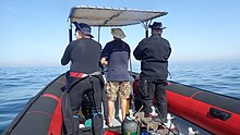
In South Africa, the standard dive boat is a large (6 to nearly 9 m) Rigid Inflatable Boat These are known as rubber ducks. Power is generally twin outboard motors, which may be two-stroke and smoky, but are increasingly often either four stroke, or the improved two-strokes which are cleaner and quieter.
These boats are generally powerful and fast, but speed is usually limited by sea state. They have a wet ride in a bumpy sea or if there is a crosswind. You travel in your dive suit, quite often with your hood on, and sometimes with your mask on to keep the spray out of your eyes. It has been known for the occasional diver to also use a snorkel to keep out heavy spray in rough conditions. If you wear a hat to protect your head from UV, make sure the hat is a tight fit, and preferably with a lanyard. The combination of cool sea air, wind, spray and high levels of UV can grill you in quite a short time, even in winter. Wear a good blockout or other method of keeping the sun from your skin. Unfortunately some blockouts wash off easily, and others sting your eyes if water gets into your mask and sloshes around a bit. A ski-mask is considered slightly eccentric, but it does the job.
Preparing for the dive.

If using all your own equipment, pack it as you find convenient, and check that everything is in good working order before leaving home. It will be wet on the way home, a waterproof bag or bin will keep the water off the upholstery. If using rental gear, get to the shop early to make sure it fits and works properly. If you are an unusual shape or size you may have difficulty finding a suit which fits well.At some places you will kit up at the side of the road or in a parking lot, and at others there will be changing rooms provided by the dive operator. If this is an issue, find out before the dive, You might want to take along a small mat or towel to stand on while putting on your suit, particularly if the ground is sandy or muddy.Some operators provide facilities at the dive shop for the customers to change into their dive suits and assemble equipment and load the boat before leaving for the launch site. In these cases the heavy equipment is usually loaded by staff, and the divers carry their light equipment to the boat. Where the boat collects divers from a jetty, the divers are expected to get their own kit to the boat. Actual loading will usually be done or supervised by the skipper.You will almost always be expected to wear your dive suit on the boat trip. There is no space to put it on during the ride, which may be wet.
What to take
- A small bag is useful to carry items like sunglasses, sunblock, hat, etc. Cell phones and car keys are usually kept in a waterproof bag or box by the skipper, and stored in the console. Large boxes for underwater cameras or video equipment should be negotiated before the dive, as there may or may not be space for them on board. In summer sunblock is advised for most skin types. UV factor is generally high and reflection from the water grills you from below. A peaked or brimmed hat may help if securely strapped on against the wind generated by boat speed.
- Kit bags for dive gear are not usually carried, but a medium sized soft bag to hold fins and mask, and other dive accessories like DSMB, reel, computer, dive light etc. is OK.
- On a long boat trip a small bottle of water or other suitable rehydration drink is nice to have, specially for after a deep or long dive. Similarly a small amount of high energy food may be welcome after a cold dive. In Cape Town, many dive boats supply a small chocolate bar or other sweet (candy) to each diver after the dive.
- A light waterproof windbreaker jacket is useful if the wind is strong, the weather or water is cold, or the trip is long. This can reduce wind-chill, particularly after the dive if you wear a wetsuit.
- A small emergency supplies (dive saver) kit of spare O-rings, fin strap, etc is acceptable.
What not to take
- Don’t take anything that you do not intend to use on the trip. (emergency equipment excepted).
- Don’t bring anything that must not get wet unless you have a watertight bag or box for it. A towel is usually a waste of time, as it will probably get wet. The same goes for dry clothing.
- Space is limited and must be shared by all. Do not annoy everyone by bringing a huge bin for your kit and fighting with the skipper at boarding time. No-one will have sympathy when you are evicted.
Loading kit and getting into the boat


The boat may loaded before launching, except where the water at the slipway is too shallow, when the boat is not taken out between dives, or when the slipway is not at the same place where the divers will be boarding.Loading of the boat is usually done by the skipper and divemaster. You are usually expected to transport your own equipment to the boat and hand it over to the person who will stow it for the trip. The standard arrangement is to stack scuba sets along a centreline rack, and tie them in place. You will usually sit at your scuba set, so if you want to do pre-dive buddy checks, ask for your gear and your buddy’s to be stowed together.Weight belts and pockets may be stacked on deck or in a box at the front or back of the rack. They are handed out when the boat gets to the site, so be sure you can identify your weights.
Fins and masks are usually stowed by the diver. There are often no special places reserved for this purpose, and fins are generally stowed either behind a handrope along the inner side of the pontoons, or between scuba sets along the rack. Be careful how you do this, as simply stacking them on top of the scuba sets can sometimes result in a fin or two being blown overboard by wind. This can ruin your dive, and is usually expensive. Masks are commonly stored in the foot pocket of a fin. The deck is not a good place for fragile items.Large cameras with strobe arms should be carried in the smallest plastic bin or crate that will hold them. There will often be several divers with camera boxes contending for the same limited storage space. Do not expect special treatment unless you have specifically organised it with the charterer.Some crews will carry your scuba set to the boat, but don’t count on it. If you need help, say so. If you are renting gear from the same organisation that runs the boat, they will usually load it for you. Make sure you can identify your rented gear and that it has all been loaded.
Slipway launches


Slipway launches are standard in the Western Cape
Where launching is from a slipway the procedure is fairly relaxed, and much depends on how far the slipway is from the parking area, and whether there is a convenient jetty.In some cases, usually at low tide, the water may be too shallow to launch the boat loaded with kit, but more often the boat is loaded with most of the dive gear, but not the divers, before launching. The boat is then launched with usually just the skipper on board, and the divers either get in from shallow water or from a jetty, as described above.Sometimes there may be commercial ski-boat fishermen launching at the same slipway. There are exceptions, but the lasting impression is of a mob of hooligans with no respect for anyone. They are generally a law unto themselves, and you will not gain brownie points by pointing out the error of their ways, and are likely to be given a brief introductory course in local invective at no charge.
Getting into the boat will depend on the launch site. In most cases the boat will be launched with only a skipper on board. Divers will board from the jetty or from the water.
Boarding from a jetty
Boarding from a jetty is usually easy, unless the step down to the boat is high. The crew will help where necessary and direct boarding. Follow their instructions. Do not leap down onto the deck, as it may not be designed to take this kind of shock load, and the sound of cracking glass fibre will not bring a smile to the skipper’s face. Also don’t leap down onto the pontoon, as this is likely to be followed by an inelegant face-plant onto the rack of scuba gear. The owners may be more concerned with damage to their equipment than your injuries.
The roll bar at the stern is a good place to hold if you can reach it. The radio antenna, plastic windscreen and engine control levers are not.Try to avoid getting parts of yourself between the boat and the jetty. The pontoons are fairly soft, but the jetty usually isn't, and may be decorated by barnacles and other abrasive material.
Boarding from shallow water
If boarding from standing in the water, try to get in where the water is not too deep, as most divers do not have the agility and upper body strength to boost themselves in without fins or a jump. Ask for help if you need it, but your fellow divers are more likely to be enthusiastic than skillful at pulling you in, Say goodbye to dignity, and hope for a reasonably comfortable landing.
The stern of the boat (blunt end) is usually lower and therefore easier to get into. This is often combined with it being in the shallowest water, so get in and out of the way of the people who have to hold the boat while the rest are getting in.
If you are a gymnast or acrobat you may safely ignore this advice.
Seating


Seating is almost exclusively on the pontoons, with your back to the water. This puts you in a position where losing your balance backwards will result in falling into the water, a manoeuvre most divers prefer to restrict to times when the boat is stationary at the dive site. To prevent unscheduled backward rolls, use the foot-straps and hand-ropes provided. As a general rule, sit opposite your scuba set, so you don’t have to move around when kitting up on site.
Occasionally there may be a seat across the stern in front of the motors. This will be the most comfortable place on the boat but may catch more spray in your face. The boat will bounce up and down as it hits waves. Bigger boats less so than small ones, and the part that bounces the least is the stern, so the most comfortable seating is as far back as you can get. This puts you close to the motors, and if they are two-stroke, closest to the exhaust smoke when the boat is not moving. You may not have much choice where you get to sit, but if you have a bad back or other disability which makes a rough ride a problem, mention this to your dive-master or the skipper as soon as possible. You will not be popular if the boat has to stop to re-arrange passengers. With practice it is possible to sit with one foot in a foot-strap (preferably the foot nearer the bow (pointy end)) and ride the bumps with very little effort. It is much like riding a horse, don’t fight the motion, absorb the bumps by relaxing a bit, and you will bounce less. A death-grip on the hand ropes will be exhausting if the ride is long.
Some boats have no footstraps. You will have to find something else to hold onto, or lean into the boat to keep more weight on your feet. Some divers may be seen comfortably sitting on the tubes, riding the waves with no obvious concern as the boat bounces along. They may not even need to hold on. They have done this before.
Moving around in the boat
If possible, don’t move around while the boat is moving, unless asked to trim the boat. You will be expected to sit where directed by the skipper, and unless there is a good reason not to, do as requested. Standing up when the boat is moving and there is nothing to hold onto can result in a fall and possible injury if the boat hits a wave or moves in an unexpected direction. If equipment comes loose under way, shout to the skipper, who will stop if it is safe, so that the equipment can be re-stowed.There may be cables and pipes in places on the deck. These are usually routed through areas where they are reasonably protected, but as a rule don’t stand on them or use them to hold on to. Batteries are often stored in plastic boxes near the transom, to keep the wires short. The lids are not usually load bearing structures, do not use them as steps.
Getting out of the boat

Getting into the water is usually done by a synchronised backward roll – falling into the water alongside your neighbour, neither on top nor underneath. Generally all the divers or a nominated group will roll off together, on a countdown from the skipper or divemaster. It is important to all roll together, as if you do not, the later divers may fall on top of the earlier ones, possibly casing injury or equipment damage. If you are not ready, or are not happy with this procedure, wait until the others are in and the boat is clear of them. The skipper will then let you roll in clear of the others, but you may have to fin a bit to get to them. This can be a problem if diving in a current. Some divers may not wish to backward roll with a large camera setup. พวกเขาสามารถขอให้กัปตันส่งกล้องให้เมื่ออยู่ในน้ำ ในกรณีนี้พวกเขาควรอยู่ใกล้เรือและควรจับมันไว้จนกว่ากล้องของพวกเขาจะถูกส่งต่อ
เส้นชอตไลน์และทุ่นเครื่องหมาย

การดำน้ำส่วนใหญ่ในเคปทาวน์อยู่ที่แนวปะการังหรือซากปรักหักพัง เป็นเรื่องปกติที่จะทำเครื่องหมายตำแหน่งด้วย shotline ก่อนดำน้ำเพื่อให้นักดำน้ำสามารถลงไปถูกที่ หากมีกระแสน้ำเล็กน้อยที่ผิวน้ำ เส้นช็อตไลน์จะล่องลอยไปตามลมเพื่อคลายความหย่อนคล้อย ในกรณีนี้ เป็นเรื่องปกติที่จะลงน้ำในระยะทางสั้น ๆ ของทุ่น และให้เริ่มการลงมาทันทีที่มองเห็นเส้นผ่านน้ำ เพื่อลดการทำงานของการว่ายทวนกระแสน้ำ การลอยไปจนถึงทุ่นหมายความว่าคุณจะต้องว่ายทุ่นกระแสน้ำ ช็อตไลน์ไม่ใช่สมอ หากคุณดึงตัวเองลงไปที่เส้นทุ่น มันอาจลากลูกยิง และคุณจะจบลงที่ไซต์งาน เช่นเดียวกับคนอื่นๆ ที่อยู่ข้างหลังคุณ หากเส้นยิงสั้นเกินไป ทุ่นอาจยกทุ่นและลอยออกนอกไซต์ ดังนั้นจึงต้องมีการหย่อนบ้าง กระแสน้ำอาจไม่ไหลลงใต้ลมโดยตรง แม้ว่าจะเป็นกระแสที่เกิดจากลม แรงโคริโอลิสจะชดเชยทวนเข็มนาฬิกาจากทิศทางลมในซีกโลกใต้ ในลักษณะที่เรียกว่าการขนส่งเอกมาน เอฟเฟกต์จะอยู่ที่พื้นผิวประมาณ 45° มากขึ้นเมื่อคุณลึกลงไป แต่ด้วยความเร็วที่น้อยลง
คุณสามารถเลือกให้ปรากฏบนเส้นช็อตไลน์หรือออกห่างจากเส้นนั้นก็ได้ หากคุณไม่รู้จักไซต์นี้ อาจเป็นเรื่องยากที่จะหาทางกลับ โดยปกติจะไม่เป็นปัญหา และนักดำน้ำของ Cape Town ส่วนใหญ่จะขึ้นไปไม่ว่าจะอยู่ที่ใดเมื่อสิ้นสุดการดำน้ำ แต่ในกรณีนี้ ขอแนะนำอย่างยิ่งให้ติดตั้ง DSMB และใช้งานบนทุ่นของคุณเองหรือทุ่นของเพื่อน DSMB จะระบุการมีอยู่ของนักประดาน้ำ เพื่อให้เรือในพื้นที่สามารถรักษาความปลอดโปร่ง และเพื่อให้กัปตันเรือดำน้ำของคุณสามารถติดตามว่าลูกค้าของเขาน่าจะไปที่ใด

หากมีโอกาสสูงที่จะหลุดออกจากเส้นช็อตไลน์ในพื้นที่ที่มีการจราจรทางเรือมาก ควรให้นักดำน้ำหรืออาจจำเป็นต้องพก DSMB ติดตัวไปและนำไปใช้ก่อนจะร่อนลงสู่ผิวน้ำ สถานที่อื่นๆ ที่นักดำน้ำอาจต้องพก DSMB นั้นอยู่นอกชายฝั่ง หรือเมื่อใดก็ตามที่กัปตันคิดว่าจะหานักประดาน้ำได้ยากเนื่องจากสภาพทะเล สำหรับการดำน้ำเพื่อการพักผ่อนหย่อนใจ การเลือกสีและขนาดสำหรับ DSMB ส่วนบุคคลนั้นขึ้นอยู่กับนักประดาน้ำ สีเหลือง สีส้ม และสีแดงเป็นสีที่พบได้บ่อยที่สุด แต่บางครั้งก็เห็นสีชมพูสดใสด้วย และเว้นแต่คุณจะแจ้งให้กัปตันทราบถึงความหมายพิเศษสำหรับสีอย่างชัดแจ้ง ระบบจะถือว่าไม่มีความหมายพิเศษอื่นใดนอกจากการทำเครื่องหมายตำแหน่งของคุณ ไม่มีใครสนใจว่ามันจะใหญ่แค่ไหน ตราบเท่าที่สามารถมองเห็นได้จากระยะไกลที่เหมาะสม แถบสะท้อนแสง ไฟกระพริบ และชื่อของคุณก็เป็นอุปกรณ์เสริมเช่นกัน
นักดำน้ำ
บนเรืออาจจะมีหรือไม่มีก็ได้ เรือที่ให้บริการสำหรับคนในท้องถิ่นมีแนวโน้มที่จะจัดหาไดฟ์มาสเตอร์น้อยกว่าเรือที่เชื่อมต่อกับโรงเรียนหรือซึ่งโดยทั่วไปจะรองรับการค้าผ่านและผู้มาเยือน หากคุณไม่มั่นใจเกี่ยวกับการดำน้ำโดยไม่มีใครพาคุณไปรอบ ๆ ให้พูดถึงสิ่งนี้เมื่อคุณจองและถามเกี่ยวกับตัวเลือกต่างๆ
ดำน้ำเคลป์
ในพื้นที่ที่มีสาหร่ายทะเลจำนวนมาก นักดำน้ำมักจะไม่ลาก SMB ในระหว่างการดำน้ำ โชคดีที่สิ่งเหล่านี้มักจะเป็นที่ที่ไม่มีกระแสน้ำที่สำคัญแม้ว่าคลื่นจะแรง บริเวณชายฝั่งทะเลและชายฝั่งของเคปทาวน์หลายแห่งมีสาหร่ายทะเลหนัก โดยเฉพาะบริเวณชายฝั่งทะเลแอตแลนติก ในพื้นที่เหล่านี้ขอแนะนำให้นักดำน้ำพกพา DSMB และใช้เมื่อออกจากเส้นช็อตไลน์ เพื่อให้กัปตันสามารถติดตามว่าทุกคนกำลังมุ่งหน้าไปที่ใด และเพื่อให้เรือที่แล่นผ่านมีโอกาสหลีกเลี่ยงการวิ่งคุณหากมีผู้ใดรบกวน เพื่อเฝ้าระวัง DSMB ยังมีประสิทธิภาพในการส่งสัญญาณไปยังเรือเมื่อคุณอยู่บนพื้นผิว มากกว่าแขนในชุดดำน้ำสีดำ สิ่งนี้มีประโยชน์อย่างยิ่งหากลมพัดขึ้นในระหว่างการดำน้ำและพื้นผิวเป็นคลื่นที่มีน้ำสีขาวขุ่น
กลับขึ้นเรือหลังจากดำน้ำ


กฎข้อที่ 1: อย่าถอดครีบในน้ำเว้นแต่จะมีบันได คุณต้องการมันเพื่อเพิ่มพลังให้คุณ เป็ดยางส่วนใหญ่ไม่มีบันไดขึ้นเครื่อง สิ่งนี้สำคัญยิ่งกว่าหากคุณกำลังขึ้นเรือที่อยู่ด้านเหนือลม เนื่องจากเรือเกือบจะล่องไปตามลมได้เร็วกว่านักประดาน้ำ เข้าหาเรือและจับเชือกมือด้านนอก พยายามยึดเรือไว้ตลอดเวลา และปล่อยทิ้งไว้ให้นานเท่าที่จำเป็นอย่างยิ่งในการถอดชุดอุปกรณ์ เนื่องจากเรืออาจลอยออกไปในขณะที่คุณไม่ได้จับ
เรือบางลำอาจมีห่วงคล้องสายสั้นๆ ที่คุณสามารถสอดแขนเข้าไปได้ แต่ด้วยเหตุผลบางอย่าง เรือลำนี้หายากมาก แม้แต่เส้นที่มีคลิปหนีบซึ่งใช้กันทั่วไปได้น้อยกว่านั้นก็ใช้ติดอุปกรณ์ได้ก่อนที่จะถอดออก สันนิษฐานว่าไม่มีความต้องการของลูกค้าสำหรับรายการเหล่านี้…อุปกรณ์ของคุณจะถูกยกขึ้นโดยลูกเรือหรือนักดำน้ำคนอื่นๆ
ขั้นตอนที่แนะนำคือการส่งต่อกล้องหรืออุปกรณ์หลวมอื่นๆ ก่อน จากนั้นจึงถอดและยกน้ำหนักของคุณ เพื่อให้แน่ใจว่าคุณจะลอยได้หลังจากลบ BC ของคุณ อย่าปล่อยมือจนกว่าคุณจะแน่ใจว่าอีกฝ่ายจับกระชับมือ เข็มขัดน้ำหนักจมเร็วมาก นำชุดดำน้ำออกแล้วยื่นให้ลูกเรือ คุณสามารถช่วยได้โดยดันขึ้นใต้ชุดเมื่อยกขึ้น และตรวจสอบว่า DV และเกจไม่ติดกับเชือกคล้องมือ หากสะดวก สามารถมอบหน้ากากและท่อหายใจได้ทุกเมื่อ จับที่จับที่ให้มาอย่างดี หรือเชือกมือให้สูงที่สุดที่ด้านข้างของโป๊ะ จุ่มตัวเองให้สูงที่สุดเท่าที่จะทำได้เพื่อยกตัวลอย จากนั้นครีบขึ้นอย่างแรงและใช้แขนของคุณดึงตัวเองให้สูงที่สุด จากนั้นกดเชือกหรือมือจับลงไปขณะกลิ้งร่างกายส่วนบนของคุณไปบนโป๊ะ เปลี่ยนด้ามจับเป็นมือจับด้านในหรือแฮนด์ไลน์ แล้วเหวี่ยงขาเข้าไปในเรือ อาจสะดวกที่จะหยุดที่นี่ในขณะที่มีคนเอาครีบของคุณออก จากนั้นลุกขึ้นนั่งแล้วเหวี่ยงขาอีกข้างหนึ่งเข้าไปในเรือ ด้วยครีบที่ดี เทคนิคที่ดีและความแข็งแกร่งที่เหมาะสม คุณสามารถขึ้นเรือด้วยวิธีนี้ได้อย่างสะดวกสบายและมีศักดิ์ศรี วิธีนี้ยากกว่ามากหากอยู่ด้านใต้ลมในลมแรง

หากคุณไม่มีกำลัง ขั้นตอนจะคล้ายกัน แต่ด้วยความช่วยเหลือจากลูกเรือหรือนักดำน้ำที่อยู่ในเรือแล้ว ใครจะลากคุณเข้าไปด้วยกำลังหลักและอะไรก็ตามที่พวกเขาสามารถจับได้ ก่อนที่จะกล่าวหาใครก็ตามที่ทำร้ายร่างกายอย่างไม่เหมาะสม ให้พิจารณาว่ามีทางเลือกอื่นที่สมเหตุสมผลสำหรับพวกเขาที่จะคว้าตัวซึ่งน่าจะได้ผลหรือไม่ ความสง่างามนั้นแปรผกผันกับขนาดและมวลของคุณ หากคุณมีกระเป๋าที่ต้นขาอยู่หน้าสูท อย่าใส่อุปกรณ์ที่บอบบางหรือเทอะทะในกระเป๋ากางเกง กระเป๋าด้านข้างมักจะไม่มีปัญหา

มีแนวโน้มใหม่กับเรือบางลำเพื่อให้เป็นบันไดขึ้นเครื่อง สไตล์ "ต้นคริสต์มาส" ค่อนข้างเป็นที่นิยมเนื่องจากง่ายต่อการปีนโดยใช้ครีบบนเท้าของคุณ บนเป็ดยางมักจะแขวนไว้ด้านข้างและบนเรือใบที่แข็งควรใช้กรอบวงกบ
ลงจากเรือหลังดำน้ำ

การออกไปยังท่าเทียบเรือมักจะตรงไปตรงมา แต่อาจเป็นเรื่องยากเพราะท่าเทียบเรือสูงและน้ำลง หากเป็นปัญหา ลูกเรือจะช่วยและให้คำแนะนำ หากคุณทำสิ่งของคุณเอง คำเตือนเดียวกันจะนำไปใช้ในการเข้าจากท่าเทียบเรือ โดยเฉพาะเรื่องการไม่เดินทางระหว่างเรือกับท่าเทียบเรือ
การออกไปเที่ยวชายหาดไม่ใช่เรื่องปกติในเคปทาวน์ แต่ค่อนข้างตรงไปตรงมา โดยปกติแล้วจะปลอดภัยกว่าและสะดวกกว่าที่จะลงจากฝั่งต่ำหากเรือเอียงขณะวิ่งขึ้นไปที่ชายหาด หากคุณอยู่บนที่สูง ให้รอจนกว่าจะมีที่ว่างและเคลื่อนตัวไปทางด้านต่ำ หรือในบางกรณี ด้านที่สูงจะกลายเป็นด้านต่ำเมื่อเรือพลิกกลับเมื่อขนถ่ายออก อย่าพยายามยกชุดอุปกรณ์ขึ้นจากที่สูง ในกรณีที่คุณอยู่ผิดที่และเรือจะพลิกคว่ำทับคุณ โดยเฉพาะอย่างยิ่งถ้าเรือไม่มีคลื่น
ดู

น่านน้ำของคาบสมุทรเคปและอ่าวเท็จสนับสนุนระบบนิเวศน์ของสิ่งมีชีวิตในทะเลที่มีอากาศเย็นที่เฟื่องฟู ส่วนมากเป็นสัตว์เฉพาะถิ่นในแอฟริกาใต้ หรือแม้แต่บริเวณที่เล็กกว่า และถึงแม้ว่าปลาจะไม่มีสีสันสวยงามเหมือนที่เห็นในน่านน้ำเขตร้อน ค่อนข้างมีสีสันเพื่ออำพรางตัวเองท่ามกลางสัตว์ไม่มีกระดูกสันหลังที่สดใสอย่างยิ่งที่ปกคลุมแนวปะการัง
สัตว์ทะเล
มีสัตว์ทะเลหลายชนิดที่อาจเห็นได้ในขณะที่ดำน้ำในภูมิภาคนี้ และรวมถึงสัตว์น้ำที่น่าตื่นตาตื่นใจและน่าตื่นตาตื่นใจที่สุดสำหรับการเผชิญหน้าที่เป็นไปได้สำหรับนักประดาน้ำ
วาฬและโลมา
False Bay เป็นจุดหมายปลายทางสำหรับการดูปลาวาฬ ทุกปีมีวาฬเซาเทิร์นไรท์เข้ามาเยี่ยมชมอ่าวเป็นจำนวนมาก แต่การดำน้ำดูปลาวาฬนั้นไม่ใช่เรื่องปกติ วาฬชนิดอื่นๆ ที่พบเห็นเป็นครั้งคราวในอ่าวเท็จ ได้แก่ วาฬหลังค่อม วาฬบรายด์ และวาฬออร์กา ซึ่งมีโอกาสน้อยที่จะเห็นวาฬเหล่านี้ขณะดำน้ำ หากคุณโชคดีที่ได้พบวาฬในระหว่างการดำน้ำ ให้ระวัง เพราะขนาดใหญ่ของพวกมันทำให้นักประดาน้ำได้รับบาดเจ็บโดยไม่ได้ตั้งใจได้ง่าย
ปลาโลมายังมีให้เห็นในอ่าวเท็จและบนชายฝั่งมหาสมุทรแอตแลนติก โลมาทั่วไปมักมาเยี่ยมโรงเรียนที่มีจำนวนตั้งแต่หลายร้อยถึงหลายพันตัว แต่นักดำน้ำมักไม่ค่อยเห็น โลมามืดครึ้มมักจะเดินทางเป็นกลุ่มเล็ก ๆ แต่ก็มีแนวโน้มที่จะสอบสวนนักประดาน้ำที่จุดจอดปลอดภัย สปีชีส์อื่นๆ มาเยี่ยมเป็นบางครั้ง แต่มักพบเห็นเหตุการณ์เกยตื้นซึ่งนักดำน้ำเห็นใต้น้ำ
ฉลาม

อ่าวเท็จเป็นหนึ่งในสถานที่ที่น่าเชื่อถือที่สุดในการชมฉลามขาวผู้ยิ่งใหญ่ แม้จะไม่ค่อยเป็นนักดำน้ำ และฉลามสายพันธุ์อื่นๆ ก็มีให้เห็นอยู่บ่อยครั้งเช่นกัน Sevengill หรือ Cowshark มักจะพบเห็นได้ในบางจุด ในขณะที่ฉลาม Gully และปลาฉลามนั้นแพร่หลายมากกว่า มีปลาฉลามทั่วไปสี่สายพันธุ์ในท้องถิ่นตั้งแต่ปลาปักเป้า Shyshark ที่มีสีสันไปจนถึงฉลามชุดนอนที่ใหญ่กว่ามาก ฉลามทะเลอื่นๆ มักจะพบเห็นได้เฉพาะในการดำน้ำ "น้ำทะเลสีฟ้า" นอกชายฝั่งนอกคาบสมุทรทางใต้ และปลาทะเลขนาดใหญ่หลายสายพันธุ์สามารถพบเห็นได้ในการเดินทางที่คล้ายกัน
Pelagics

ฝูงปลาหางเหลืองขนาดใหญ่มักพบเห็นได้ในบางจุดดำน้ำ และในโอกาสที่คาดเดาไม่ได้ นักดำน้ำอาจโชคดีที่ได้เห็นปลาซันฟิชโอเชียนิก วาฬเซาเทิร์นไรท์ วาฬหลังค่อม โลมาปากขวด หรือโลมาปากขวด
Snoek ทั่วไปซึ่งเป็นรากฐานที่สำคัญของอุตสาหกรรม linefishing ในท้องถิ่นนั้นเป็นนักดำน้ำที่ขี้อายและแทบจะไม่เคยเห็นนักดำน้ำ แม้ว่าจะมีนิสัยชอบตกปลาเป็นจำนวนมาก
เพนกวินและแมวน้ำ

มีฝูงนกเพนกวินแอฟริกันอยู่ในอ่าวเท็จ แต่การเห็นพวกมันในระหว่างการดำน้ำนั้นเป็นเรื่องผิดปกติอย่างยิ่ง ในทางกลับกัน แมวน้ำ Cape fur นั้นทั้งอยากรู้อยากเห็นและไม่กลัวนักดำน้ำ และมักพบเห็นได้ทั่วไปทั้งใน False Bay และบนชายฝั่งมหาสมุทรแอตแลนติก มีหลายสถานที่ซึ่งเกือบจะรับประกันได้ว่าจะได้เห็น
ปลาแนวปะการัง


ปลาในแนวปะการังในภูมิภาคนี้มีความหลากหลายมากที่สุดใน False Bay และพบได้ทั่วไปในเขตหวงห้ามของพื้นที่คุ้มครองทางทะเล ซึ่งได้รับการคุ้มครองตามกฎหมายมาเป็นเวลาหลายทศวรรษ แม้ว่าการรุกล้ำจะยังคงเกิดขึ้น และการบังคับใช้ก็ค่อนข้างไม่น่าเชื่อถือ ปลาในแนวปะการังส่วนใหญ่พรางตัวได้ในระดับหนึ่ง หลายตัวมีสีเทาเงินและแรเงาสีเทา เช่น ปลาซีบรีม Hottentot ที่แพร่หลาย, Fransmadam สีเงิน และ Steentjie บางชนิดมีแถบแนวตั้งหรือรอยด่างดำซึ่งอาจช่วยแยกส่วนโปรไฟล์ของพวกมันในสาหร่ายทะเล เช่น ตอไม้ขาว ม้าลาย และสตีนบราสีขาว ในขณะที่สปีชีส์ขนาดเล็กกว่าหลายสายพันธุ์จะมีสีลึกลับและกลมกลืนกับสภาพแวดล้อมได้ดีมาก โดยทั่วไปแล้วสิ่งเหล่านี้คือปลาที่ใช้เวลาส่วนใหญ่บนหรือใกล้กับแนวปะการัง และสีของพวกมันมักจะบ่งบอกถึงสีทั่วไปของที่อยู่อาศัยของพวกมัน เหล่านี้รวมถึงปลาคลิปฟิชประจำถิ่นต่างๆ และเบลนนี่และโกบี้สองสามตัว, fingerfins, Cape triplefin, Smoothskin scorpionfish, horsefish 2 สายพันธุ์, pipefish และ Rocksucker นอกจากนี้ยังมีปลาสีแดงสองสามตัวซึ่งมองเห็นได้ชัดเจน เช่น ปลาโรมันทั่วไป ปลาตอแดงและสตีนบราสีแดงที่พบได้น้อย ปลาที่กล่าวถึงส่วนใหญ่อยู่ตามลำพังหรือพบในสันดอนขนาดเล็ก แต่ก็มีปลา Strepies และ Maasbanker ซึ่งมีแนวโน้มว่าจะมีจำนวนมากพอสมควร และฝูงปลา Hottentot ที่มีขนาดปานกลางมักพบเห็นได้ค่อนข้างบ่อย Galjoen ค่อนข้างหายากและมักพบเห็นเป็นกลุ่มเล็กๆ ด้านบนของแนวปะการังซึ่งมีการเคลื่อนไหวของคลื่นเป็นจำนวนมาก และ Cape knifejaw ที่ดูคล้ายคลึงกันชอบแนวปะการังที่ลึกและมีรายละเอียดสูงระหว่างโขดหิน ปลาดุกขี้อายและมักจะใช้เวลากลางวันในรอยแยกและรู
พื้นที่ทราย

บริเวณที่เป็นทรายยังมีปลาที่มีลักษณะเฉพาะ ซึ่งรวมถึงปลากระเบน ฝ่าเท้า ปลากระเบน ปลาปักเป้า และปลาทรายจงอย ซึ่งหาได้ยากและขี้อายในตอนกลางวัน แต่อาจพบเห็นได้เป็นจำนวนมากในตอนกลางคืนในบางพื้นที่เมื่อ มันโผล่ออกมาจากทราย มันซ่อนตัวและแหวกว่ายไปมาอย่างอิสระ ปลาคลิปฟิชบางสายพันธุ์ก็เป็นที่อยู่อาศัยด้วยทรายเช่นกัน โดยหลายสายพันธุ์ชอบทรายที่มีความหนาแน่นต่างกัน โดยที่พวกชอบทรายละเอียดจะมีลำตัวเหมือนงูมากกว่า ในขณะที่ปลาในทรายหยาบจะแข็งแรงกว่า ลวดลายของร่างกายก็มักจะเข้ากับชนิดของทรายเช่นกัน
สัตว์ไม่มีกระดูกสันหลังแนวปะการัง
สัตว์ไม่มีกระดูกสันหลังหน้าดินให้สีสดใสส่วนใหญ่บนแนวปะการังของภูมิภาคนี้ และการกระจายของสายพันธุ์เป็นลักษณะเฉพาะของภูมิภาคย่อยต่างๆ เช่น ความลึกและอุณหภูมิของน้ำ ความหลากหลายมีขนาดใหญ่ และมีความหลากหลายอย่างมากในแนวปะการังที่โดดเด่นซึ่งมีทั้งความลึกและที่ตั้งทางภูมิศาสตร์ ลักษณะชีวิตของแนวปะการังแตกต่างกันไปอย่างมากระหว่างฝั่งตะวันออกและตะวันตกของคาบสมุทรเคป และสิ่งนี้ได้รับการยอมรับว่าเป็นพรมแดนระหว่างเซาท์เวสเทิร์นเคปและอากุลฮาสในชายฝั่งไบโอรีเจียน การแบ่งเขตตามแนวตั้งยังเป็นลักษณะเฉพาะของไบโอรีเจียนต่างๆ ดังนั้นจึงสามารถเห็นความแตกต่างที่เห็นได้ชัดเจนในไซต์ต่างๆ
มีแนวโน้มทั่วไปที่บริเวณแนวปะการังที่กำหนดจะถูกครอบงำโดยสิ่งมีชีวิตบางชนิด เช่น ดาวขนนกทั่วไป ปลิงทะเลอกแดง ปลิงทะเลสีม่วง เหยื่อแดง หรือเม่นทะเล จนถึงขนาดที่สำคัญ ส่วนหนึ่งของพื้นที่ผิวถูกปกคลุมด้วยสิ่งมีชีวิตที่โดดเด่น นี่ไม่ได้หมายความว่าไม่มีความหลากหลาย เนื่องจากมีแหล่งที่อยู่อาศัยมากมายในแนวปะการังส่วนใหญ่ขึ้นอยู่กับทิศทางและความหยาบกร้าน และในขอบเขตมาก สิ่งมีชีวิตที่อาศัยอยู่บริเวณที่พวกมันสามารถดำรงชีวิตได้ และสิ่งนี้ส่วนใหญ่ขึ้นอยู่กับว่าตัวอ่อนของแพลงก์ตอนอยู่ที่ใด หาที่ยืน
มิดวอเตอร์
สัตว์ไม่มีกระดูกสันหลังทะเลมีลักษณะเป็นแพลงก์โทนิกโดยส่วนใหญ่ไม่สามารถคาดเดาได้ว่าจะมองเห็นเมื่อใดและที่ไหน พวกมันรวมถึงแมงกะพรุนหลายสายพันธุ์ หวีเยลลี่บางสายพันธุ์ กาลักน้ำ salps และ pteropods ประปราย และสิ่งต่างๆ มากมายที่เล็กเกินกว่าจะสังเกตได้ง่าย มีปลาหมึกด้วย แต่พวกมันขี้อายมากและไม่ค่อยเห็นในตอนกลางวัน
ฟองน้ำ, cnidarians, comb jellys, flatworms, segmented worms, arthropods, molluscs, bryozoans, echinoderms, ascidians, ปลา, นกทะเลและสัตว์เลี้ยงลูกด้วยนมในทะเลที่บันทึกจากภูมิภาคนี้มีรายชื่ออยู่ใน วิกิพีเดีย:รายชื่อสัตว์ทะเลในคาบสมุทรเคปและอ่าวเท็จ. หลายคนอาจเห็นสิ่งเหล่านี้โดยนักประดาน้ำเพื่อการพักผ่อนหย่อนใจ
สาหร่าย
ป่าสาหร่ายทะเล
ป่าเคลป์เป็นสาหร่ายทะเลที่ชัดเจนที่สุดของเคปทาวน์ มีสามจำพวกที่พบในท้องถิ่น บางครั้งอยู่ใกล้กัน ที่เห็นได้ชัดเจนที่สุดคือต้นไผ่ทะเล ซึ่งเมื่อโตเต็มที่จะถึงผิวน้ำ และมีก้านหนาที่มีช่องเติมก๊าซอยู่ด้านบน และช่วยให้เฟินอยู่ใกล้ผิวน้ำเพื่อให้ได้รับแสงสูงสุด สาหร่ายทะเลชนิดนี้พบได้ทั่วไปบนชายฝั่งมหาสมุทรแอตแลนติก และยังพบได้ทั้งสองด้านของอ่าวเท็จ แต่โดยทั่วไปจะไปทางตอนใต้ของอ่าว
สาหร่ายสปลิตที่มีขนาดเล็กกว่าจะเติบโตบนแนวปะการังที่ลึกกว่าและไม่ถึงผิวน้ำ ก้านจะสั้นกว่าและไม่มีช่องเติมก๊าซ ดังนั้นใบจะจมอยู่ในน่านน้ำที่มืดกว่า สาหร่ายทะเลชนิดนี้พบได้ในน้ำลึกกว่าไผ่ทะเลซึ่งมีภูมิประเทศใกล้เคียงกัน
ที่สามคือสาหร่ายเคลป์ซึ่งมีกระจุกของก้านใบยาวบาง ๆ มีใบยาวและกระเพาะปัสสาวะที่เต็มไปด้วยก๊าซขนาดเล็กจำนวนมากซึ่งทำให้สาหร่ายทะเลตั้งตรงและเฟินที่ผิวน้ำ ไม่พบสาหร่ายเคลป์นี้ในอ่าวเท็จ และพบเห็นได้ทั่วไปใกล้กับเกาะร็อบเบิน
สนามหญ้าสาหร่ายและพื้นป่าสาหร่ายเคลป์
ด้านล่างของสาหร่ายเคลป์ แนวปะการังในบริเวณที่ตื้นกว่าที่มีแสงสว่างเพียงพอ อาจปกคลุมไปด้วยสาหร่ายนานาชนิดใต้ชั้น และชนิดพันธุ์เฉพาะจะขึ้นอยู่กับปัจจัยหลายประการ รวมทั้งปริมาณแสงที่มีอยู่ และปริมาณน้ำ การเคลื่อนไหว ตามกฎแล้ว สาหร่ายสีเขียวและสีน้ำตาลจะพบได้ในบริเวณที่ตื้นกว่า และสีแดงจะลึกกว่า เนื่องจากสามารถอยู่รอดได้โดยใช้แสงน้อย ที่ลึกที่สุดมักเป็นสาหร่ายสีแดงปะการัง ซึ่งสามารถสร้างสนามหญ้าหนาแน่นบนพื้นผิวด้านบนของหิน
ปะการังที่ห่อหุ้ม
ในที่ที่คลื่นแรงเกินไปหรือแสงสลัวเกินไปสำหรับสาหร่ายชนิดอื่น สาหร่ายปะการังที่ห่อหุ้มไว้อาจยังคงตั้งหลักและเจริญเติบโตได้ สาหร่ายสีแดงเหล่านี้สร้างเปลือกแข็งและเกาะติดแน่นบนแนวปะการัง และยังเป็นที่รู้จักกันในนาม "สีชมพู" ซึ่งเป็นคำอธิบายที่ยุติธรรมเกี่ยวกับลักษณะที่ปรากฏของพวกมัน พวกมันดูไม่เหมือนสาหร่ายเลย ระยะของพวกมันอยู่เกือบทุกที่ในภูมิภาคที่มีแสงส่องผ่านเข้ามาเพียงพอ และไม่มีผู้อยู่อาศัยรายอื่นบนแนวปะการังอยู่แล้ว
มีสาหร่ายสีเขียวประมาณ 57 ตัว สาหร่ายสีน้ำตาล 49 ตัว และสาหร่ายสีแดง 240 ตัวที่บันทึกจากภูมิภาคนี้ใน วิกิพีเดีย:รายชื่อสาหร่ายในคาบสมุทรเคปและอ่าวเท็จ.
เรืออับปาง

แหลมพายุ และ แหลมกู๊ดโฮป เป็นทั้งชื่อดั้งเดิมของภูมิภาคนี้ และด้วยเหตุผลที่ดี สภาพอากาศอาจเลวร้ายในบางครั้ง และชายฝั่งเปิดโล่งมาก มีท่าเรือที่กำบังไม่กี่แห่ง แต่ยังเป็นจุดอ้างอิงที่สำคัญในเส้นทางการค้าทางทะเลที่ยิ่งใหญ่ที่สุดแห่งหนึ่งของโลก เป็นผลให้มีจำนวนเรืออับปางที่น่ากลัวที่บันทึกไว้ตามแนวชายฝั่งในท้องถิ่น
ซากเหล่านี้จำนวนมากไม่เคยพบมาก่อน และอีกหลายแห่งถูกพังทลายจนจำไม่ได้ หรือถูกปกคลุมด้วยทราย หรือในกรณีของอ่าวเทเบิ้ล ถูกฝังอยู่ใต้โครงการถมที่ดิน แต่มีหลายแห่งอยู่ในที่ดำน้ำได้และอาจเข้าไปเยี่ยมได้โดย นักดำน้ำหากเงื่อนไขเหมาะสม
ความลึกของซากเรือดำน้ำได้ตั้งแต่ 3 หรือ 4 เมตร ไปจนถึงมากกว่า 65 เมตร และสภาพแตกต่างกันไปตั้งแต่เศษไม้หรือเหล็กที่ฝังไว้ครึ่งหนึ่ง ไปจนถึงเรือที่คงไว้ซึ่งโครงสร้างและรูปลักษณ์ดั้งเดิมส่วนใหญ่ และโผล่ออกมาจากส่วนลึกราวกับว่า แล่นผ่านพื้นทราย
ส่วนใหญ่ปกคลุมไปด้วยสิ่งมีชีวิตในแนวปะการังอย่างหนัก ตั้งแต่สาหร่ายทะเลในน้ำตื้นไปจนถึงสัตว์ไม่มีกระดูกสันหลังหลากสีสันในน้ำลึก พวกเขายังเป็นที่พักพิงของปลาในแนวปะการังที่หลากหลาย และอาจมาเยี่ยมโดยปลาทะเลในโอกาสที่คาดเดาไม่ได้ ผลที่ได้คือพวกมันทำหน้าที่เป็นแนวปะการังเทียมและด้วยเหตุนี้โดยทั่วไปจึงเป็นที่สนใจของนักดำน้ำที่ไม่สนใจเป็นพิเศษว่าเป็นสิ่งประดิษฐ์
ลักษณะภูมิประเทศ
ไซต์หลายแห่งมีลักษณะภูมิประเทศที่น่าสนใจ รวมทั้งยอดแหลม ลำธาร ถ้ำ การว่ายน้ำผ่าน และส่วนที่ยื่นออกมา ลักษณะเด่นเหล่านี้ไม่เพียงแต่โดดเด่นในด้านการมีส่วนร่วมในท้องทะเลเท่านั้น แต่ยังให้รูปแบบที่สำคัญในแหล่งที่อยู่อาศัยที่มีอยู่ ณ ไซต์ดังกล่าว และผลที่ได้คือความสัมพันธ์ที่แน่นแฟ้นระหว่างความหลากหลายทางชีวภาพสูงและภูมิประเทศที่น่าสนใจ ลักษณะภูมิประเทศโดยทั่วไปของไซต์นั้นขึ้นอยู่กับธรณีวิทยา และไซต์หินแกรนิตสามารถแยกแยะได้ทันทีจากหินทรายตะกอนและไซต์หินดินดาน หินแกรนิตโดยทั่วไปจะมีลักษณะกลมและเรียงซ้อนกันเป็นหินแกนหลักบนโขดหินก้อนเดียวกัน มักมีทรายควอทซ์สีขาวคั่นกลาง หรือเป็นฐานที่ลาดเอียงทีละน้อย กองหินขนาดต่างๆ เหล่านี้มักจะก่อตัวเป็นยอดแหลม และเป็นร่องน้ำในทิศทางที่ค่อนข้างสุ่ม และบางครั้งก็ยื่นและรูระหว่างหินเหล่านั้นซึ่งใหญ่พอที่นักดำน้ำจะว่ายได้ ทำให้เกิดโครงสร้างแนวปะการังที่สวยงามตระการตา
ชั้นหินทรายมีแนวโน้มที่จะก่อให้เกิดการก่อตัวที่ครอบงำโดยการจุ่มและการกระแทกในท้องถิ่น และสามารถคาดการณ์ได้มากกว่านี้ อย่างไรก็ตาม รายละเอียดในระดับที่เล็กกว่ามีแนวโน้มที่จะทำให้เกิดรู รอยแยก หิ้ง และสันเขาเล็กๆ มากกว่าพื้นที่หินแกรนิต และสิ่งเหล่านี้มักจะไม่น่าตื่นเต้นเท่าตามกฎทั่วไป มีข้อยกเว้นอยู่ตรงที่แนวปะการังหินทรายมีลักษณะขรุขระมาก โดยปกติบริเวณที่น้ำลึกจะค่อนข้างชัน แต่ไม่แนวตั้ง และแนวชายฝั่งค่อนข้างสูงชัน แต่อยู่ในระนาบที่แตกต่างออกไป
โชคดีที่คำกล่าวแบบเก่า "ดังข้างบน ข้างล่างนี้" ใช้ได้ค่อนข้างดี และสามารถทำนายลักษณะของแนวปะการังได้อย่างน่าเชื่อถือโดยการสังเกตแนวชายฝั่งที่อยู่ติดกัน ข้อยกเว้นที่สำคัญสำหรับกฎข้อนี้คือทางใต้ของอ่าว Smitswinkel ซึ่งมีหินทรายอยู่เหนือน้ำและหินแกรนิตด้านล่าง
โครงสร้างทางธรณีวิทยาและประวัติศาสตร์ของภูมิภาคนี้มีคำอธิบายสั้น ๆ ใน วิกิพีเดีย:ธรณีวิทยาทางทะเลของแหลมคาบสมุทรและอ่าวเท็จ
อ่าน
หนังสืออ้างอิงเกี่ยวกับนิเวศวิทยาของน่านน้ำเคปทาวน์:
จาก SURGเฉพาะสำหรับนักดำน้ำในภูมิภาคนี้: มีจำหน่ายจากร้านดำน้ำและร้านหนังสือบางแห่งในเคปทาวน์ และสั่งตรงจาก SURG
- โจนส์, จอร์จินา. 2551. คู่มือภาคสนามสำหรับสัตว์ทะเลของคาบสมุทรเคป, SURG, เคปทาวน์. ISBN 9780620416399
- ซซิลาเวซ, กุยโด. 2548. ปลาชายฝั่งของแหลมคาบสมุทรและอ่าวเท็จ False, SURG, เคปทาวน์. ไอเอสบีเอ็น 0620342307
- ซซิลาเวซ, กุยโด. 2550. Nudibranchs ของ Cape Peninsula และ False Bay, SURG, เคปทาวน์. ไอเอสบีเอ็น 0620380543
จากผู้เผยแพร่รายอื่นและแอปพลิเคชันทั่วไป:
- สาขา ก. และสาขา ม. 2524 ชายฝั่งมีชีวิตของแอฟริกาใต้, Struik, เคปทาวน์. ไอเอสบีเอ็น 0869771159
- สาขา จี.เอ็ม. กริฟฟิธส์ ซี.แอล. Branch, ML และ Beckley, L.E. 2010, Two Oceans – คู่มือชีวิตใต้ทะเลของแอฟริกาใต้, เดวิด ฟิลิป, เคปทาวน์. ISBN 9781770077720
- กอสไลเนอร์, ต. 1987. Nudibranchs ของ Southern Arica, ผู้ท้าชิงทะเล & เจฟฟ์ ฮามันน์, มอนเทอร์เรย์ ไอเอสบีเอ็น 0930118138
- Heemstra, P. และ Heemstra E. 2004, ปลาชายฝั่งทางตอนใต้ของแอฟริกา, NISC/SAIAB, เกรแฮมส์ทาวน์
- เอ็ด. สมิธ, เอ็ม.เอ็ม. และ Heemstra, P. 2003 ปลาทะเลของสมิ ธ. Struik, เคปทาวน์
- สเตเกนก้า, เอช. โบลตัน, เจ.เจ. และ Anderson, R.J. 1997, สาหร่ายแห่งชายฝั่งตะวันตกของแอฟริกาใต้. Bolus Herbarium, เคปทาวน์ ISBN 079921793X (ค่อนข้างเทคนิค)
หนังสืออ้างอิงเกี่ยวกับธรณีวิทยาของคาบสมุทรเคป:
- คอมป์ตัน, จอห์น เอส. 2004, โขดหินและภูเขาแห่งเคปทาวน์. สองชั้น, เคปทาวน์. ISBN 1919930701

![]()